basemap, onx, G earth , now gohunt....lots of options. Some of them are going to have seriously focus on adding value because thats is going to be the deciding factor to Differentiate themselves from the competition. I like what gohunt is doing. I might just have to end my vacation from it and rejoin
Navigation
Install the app
How to install the app on iOS
Follow along with the video below to see how to install our site as a web app on your home screen.
Note: This feature may not be available in some browsers.
More options
You are using an out of date browser. It may not display this or other websites correctly.
You should upgrade or use an alternative browser.
You should upgrade or use an alternative browser.
3D Mapping Beta on goHunt
- Thread starter stealthy_bowman
- Start date
Wildabeest
Well-known member
Ease of use will be the deciding factor on this. I’ve worked in software development for 30+ years, and if there’s one thing I’ve learned, it’s that end users (at least non-technical ones) generally have a pretty short attention span. So if your user interface is not intuitive and easy to use, then it won’t be successful. Regardless of what whiz bang features you’ve got on the backend. Unfortunately, lots of software developers build things they think are cool - which oftentimes is way too complicated for the non-technical end user.
stealthy_bowman
Well-known member
That’s just it, it looks like gohunt is going for the integrated platform, the Amazon of hunting if you will. Kudos to them if they can pull it off.basemap, onx, G earth , now gohunt....lots of options. Some of them are going to have seriously focus on adding value because thats is going to be the deciding factor to Differentiate themselves from the competition. I like what gohunt is doing. I might just have to end my vacation from it and rejoin
Shangobango
Well-known member
After playing around on goHunt maps for a few minutes the one positive that sticks out is the 3D view. The elevation layers are a little busy for my taste. I can see how they may be beneficial to someone who doesn't read topo's well.
Right now the main thing that sticks out is goHunt has 11 States and OnX has 50.
I'm already paying for both services so no real biggie.
Right now the main thing that sticks out is goHunt has 11 States and OnX has 50.
I'm already paying for both services so no real biggie.
Hopefully they are prepared to NOT bundle it with insider and offer it as a separate app and subscription purchase that will compete with the likes of "Basemap". On-x is "in my eyes" overpriced for what you get. I am not saying that it's not a superb hunters tool as it is. It's just overpriced given some competitors in the same space. Hopefully Go Hunt will see the value in separating their mapping app/tool from their insider subscription? Not every hunter needs a subscription to insider but every hunter can benefit from the tools of 3D Hunt mapping applications on a mobile device.
They will be providing a single state "map only" option.
seeth07
Well-known member
How about all the eastern States? That's a deal breaker for lots out here I'm sure.They will be providing a single state "map only" option.
rustednuts
Well-known member
- Joined
- Apr 7, 2018
- Messages
- 807
doubtful, GoHunt is very clear about being a western hunter resource, it was said multiple times in the video. It is core to their brandHow about all the eastern States? That's a deal breaker for lots out here I'm sure.
get-n-birdy
Well-known member
- Joined
- Dec 8, 2016
- Messages
- 206
After playing with the gohunt mapping tonight, it's got the cool factor for sure. But can it sustain and compete when onx figures out the same thing for all 50 states? A lot of eastern hunters, hunt out west, but doubt the amount of western hunters that hunt out east is even a blip on the radar. Point being, there are a lot more hunters out east, and a significant market gohunt is very willfully admitting to ignore. Imo, possibly not a great long term business strategy, in an arena that is selling available data and the software that is constantly being upgraded and manipulated to the N'th degree. Or it could be brillant and not spreading itself to thin to fast, leaving areas to conquer and make more money in the future. Onx probably hasn't laid all it's cards on the table yet. And even after just a little use of the gohunt mapping, all be it a seemingly great tool, seems a tad bit clumsy and unpolished yet compared to google or onx. That could be just operator error and not being totally acclimated to it yet and it being new. Will give them a break on that, but at least they have a foot in the door. Make hay when the sun shines.
After using and going through a lot of fish finders over the years, from the old school first gene flashers, to the more modern units with down imaging, side imaging and gps that are available now, companies are always one up'ing each other as technologies advance. Stayed with lowrance for a long time because of ease of use and a better operating system, but left them for humminbird because of better clarity imo on the down imaging and side scanning. Put a better product out and people will find it. If that product is hard to use or glitchy, consumers will only tolerate it for so long, and someone else will come along and fill that hole. Brand loyalty only stays as long as the consumer doesn't have a cheaper, similar or better option. Competition is a great thing and can produce some great ideas and tools for the consumer.
Fun to see the advances that are going on, but just like fishing to a certain degree, technology can only do so much for you even if you really know how to use it. And all the technology mediums from phones, to laptops still can't give you an over all picture of an area like a big map spread out and knowing how to read it with a smart phone app or computer and how everything ties together. The detail that is coming out is great, but it is just another tool in the end and has it's uses. But you also can start seeing the mystery is starting to be lost a little bit.
Shangobango
Well-known member
How about all the eastern States? That's a deal breaker for lots out here I'm sure.
Yup. If someone that hunts east and west is going to choose a mapping service it stands to reason that they would choose one that has both sides of the country.
For me goHunt is worth the price to be an insider just based on their filtering service and their gear shop.
Last edited:
Mallardsx2
Well-known member
- Joined
- Apr 4, 2015
- Messages
- 3,347
I am not too fond of how they set up the tilt and pan on the 3D mapping in their beta version. I guess I am so used to google earth that I was hoping the controls would be very similar.
I find gohunt to be extremely valuable, but i also apply in a lot of states and for multiple species. I agree, if you are hunting 1 state it definitely would not be worth the cost. I don’t agree with the philosophy that just because you can find info for “free” that it isn’t worth the cost. I could roof my house for “free” and not have to pay anyone. It would just take a lot of time and energy that could be spent towards something else, and i wouldn’t do as good of job as the pros.For a one state hunter like me the gohunt makes no sense. Besides, I'd never pay for info I can find for free. mtmuley
If you want a 7-day free trial, with maps, here is your link - https://www.gohunt.com/hunttalk
randy, how long will this free trial be available? not starting it now because i'm leaving town for no cell service for 10 days here in a couple days, will be looking to give it a go when i'm settled in a couple weeks
randy, how long will this free trial be available? not starting it now because i'm leaving town for no cell service for 10 days here in a couple days, will be looking to give it a go when i'm settled in a couple weeks
Not sure. They usually run it for a month.
2rocky
Well-known member
Does Go Hunt have a site or email address for Beta comments?
Does Go Hunt have a site or email address for Beta comments?
i feel dumb bothering randy with my question cause i shortly after found this e-mail: [email protected]
WapitiBob
Well-known member
7 day trial, requires a credit card.
D
Deleted member 28227
Guest
Kinda seems apples to oranges to me, gohunt looks like a cool tool if you're on public and are interested in terrain.
OnX is about landownership and access.
OnX is about landownership and access.
Nameless Range
Well-known member
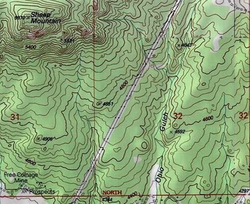
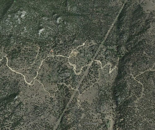
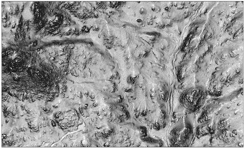
Experience ground truthing what you think you "see" on maps and 3d images is the ultimate "game changer".
What looks "good" on a topo, aerial photo, or 3d image may be a whole different story on the ground...for all kinds of reasons. I've been reading maps and photos for 40 years, google earth since about the time it was introduced. Still get fooled from time to time, by the reality of what's on the ground when I show up to places in person.
One of my favorite things to think and philosophize about.
Same AOI on USGS Quad, Google Earth, and LiDAR. None of em tell the tale like walking it on the ground.


stealthy_bowman
Well-known member
[email protected]Does Go Hunt have a site or email address for Beta comments?
Similar threads
- Replies
- 3
- Views
- 1K
- Replies
- 11
- Views
- 11K


