- Joined
- Jul 22, 2013
- Messages
- 499
I do not believe that feature is on the roadmap in the near future, but I will pass your request along to our engineering team!Will OnX add the ability to toggle between 10ft, 20ft, or 40ft contours?



Follow along with the video below to see how to install our site as a web app on your home screen.
Note: This feature may not be available in some browsers.

I do not believe that feature is on the roadmap in the near future, but I will pass your request along to our engineering team!Will OnX add the ability to toggle between 10ft, 20ft, or 40ft contours?
You should be able to go into My Content> Click Select>Choose Waypoints to Delete> Click Delete Button. If that process does not work on your end, please send us an email or give us a call and we can help you get those waypoints deleted. Our email is [email protected] and our phone number is (406) 540-1600.I’ve tried selecting say 50+ way points at once to delete. We weren’t able to do it. Had to do it one by one.

The Medium Detail maps are probably going to be your best bet. The image quality is slightly less than the High Detail maps, but you're able to save a much bigger area. The exact dimensions will vary based on your device and screen dimensions, but the largest medium detail map you can currently save will be about 35 miles east to west by 50 miles north to south. If you need to save a larger area, you can save multiple maps in a grid pattern to cover the area you need.How large of an area can I realistically save as a offline map and still retain pretty good quality?
I've got about an 80 mile x 80 mile square that I do quite a bit of my recreating on.
ps - would try it myself on the Galaxy Tab a9 but I don' have it in my possession as I write this
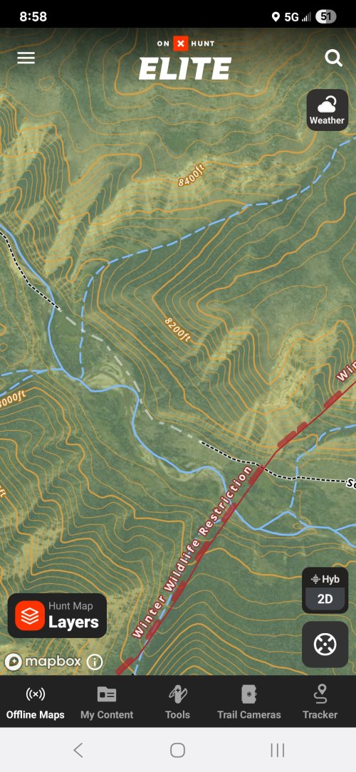
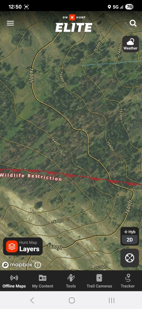
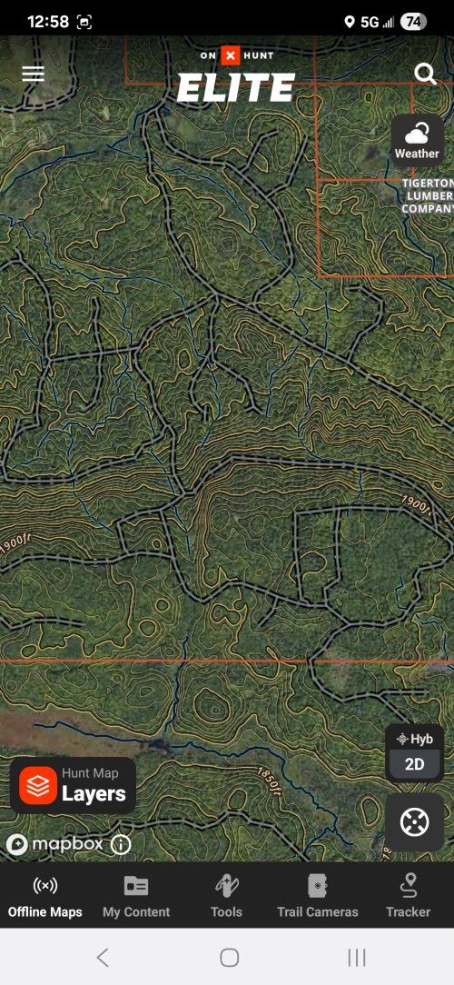
That is a new style that we recently released for the hybrid basemap. I can see what you mean about it being a little messy in your area. I'll pass your feedback along to our mapping team to see if they can make some adjustments to make that map look a little bit cleaner.Im not sure if its because of a phone update or an Onx update, but on my android, the Topo lines now have a yellow line AND a black line going through them and its making the maps look REALLY messy when you zoom out any distance. I checked the settings and couldn't see how to adjust the color or lines for the topo lines?
Old picture first:
View attachment 380810
View attachment 380811
It just feels really messy and off putting to use
View attachment 380812
How large of an area can I realistically save as a offline map and still retain pretty good quality?
I've got about an 80 mile x 80 mile square that I do quite a bit of my recreating on.
ps - would try it myself on the Galaxy Tab a9 but I don' have it in my possession as I write this
Absolutely the same issue for me. I really prefer the old imagery vs the new more “cartoon” lookIm not sure if its because of a phone update or an Onx update, but on my android, the Topo lines now have a yellow line AND a black line going through them and its making the maps look REALLY messy when you zoom out any distance. I checked the settings and couldn't see how to adjust the color or lines for the topo lines?
Old picture first:
View attachment 380810
View attachment 380811
It just feels really messy and off putting to use
View attachment 380812
Yeah, I had to open up the gohunt maps after not using it for 2 years just to make sure I really like onx better. Its getting close to just saying "so long" to onx if it keeps heading this direction.Absolutely the same issue for me. I really prefer the old imagery vs the new more “cartoon” look
Im always curious when a company makes a change to a product that seems to only be for change sake. @onX Hunt , what did this change do to improve the product?That is a new style that we recently released for the hybrid basemap. I can see what you mean about it being a little messy in your area. I'll pass your feedback along to our mapping team to see if they can make some adjustments to make that map look a little bit cleaner.
Here’s some context behind the update:Im always curious when a company makes a change to a product that seems to only be for change sake. @onX Hunt , what did this change do to improve the product?
Thank you so much for the detailed response! I'd say, from my perspective, it did the opposite of all of those things. It made it more difficult to see the layers, made the images more noisy, and the variable contours never really offer any relief to the noise by zooming in or out in sn attempt to see better. YMMVHere’s some context behind the update:
- Improved Visibility Across Terrain Types: The previous contour styling, while familiar, often blended into the aerial imagery—especially in some densely forested areas, snow-covered terrain, or low-contrast imagery. This made it hard to read elevation and terrain clearly at certain zoom levels.
- New Dual-Line Styling: The new style uses a subtle double-line technique with carefully tuned light and dark strokes. This helps contours stand out regardless of the background—whether you’re looking at dark timber, snow, or bare ground—without overpowering the aerial imagery. It was designed specifically to balance legibility with preserving image detail.
- Less Visual Noise at Critical Zooms: The older style could make the map feel cluttered or overly busy at mid-zoom levels. The updated approach aims to preserve contour utility while reducing visual overload so you can see both terrain and imagery clearly during planning or in-field use.
- Data Improvements as Well: With this visual update, we also upgraded the underlying contour data. This includes variable intervals depending on terrain: some areas now show 10’, 20’, or 40’ spacing based on the source data. This may make some areas appear more “dense” with contours than before.
On my desktop PC, using "medium' detail quality, it is only allowing 25.1 miles east-to-west and 32.3 miles north-to-southThe Medium Detail maps are probably going to be your best bet. The image quality is slightly less than the High Detail maps, but you're able to save a much bigger area. The exact dimensions will vary based on your device and screen dimensions, but the largest medium detail map you can currently save will be about 35 miles east to west by 50 miles north to south. If you need to save a larger area, you can save multiple maps in a grid pattern to cover the area you need.
On my desktop PC, using "medium' detail quality, it is only allowing 25.1 miles east-to-west and 32.3 miles north-to-south
Is there a way to alter the dimensions of the map grid. 35 mi. e/w and 50 mi. n/s would be perfect for me
At this time, the length/width ratio on the Web Map is fixed. Like WapitiBob said, to cover a bigger area, you'll just need to save a few maps in a grid pattern to cover the larger area. Alternatively, you could try saving on your mobile device. The length/width dimensions are different depending on the device you are on, so you may get slightly larger maps on a mobile device.On my desktop PC, using "medium' detail quality, it is only allowing 25.1 miles east-to-west and 32.3 miles north-to-south
Is there a way to alter the dimensions of the map grid. 35 mi. e/w and 50 mi. n/s would be perfect for me
yep, that's what I'll do. I had laid out 20 of the medium detail grids and still had tons of gb's leftNope, zoom in/out and what you see is it. Just do multiple hi res maps. I've had over 100 hi res maps on the phone at one time.