I'm over the 1500 waypoint limit. Will there be a way to organize waypoints into say, folders (i.e. by state/unit), that I can then turn on/turn off the entire folder of waypoints?
@onX Hunt In case you missed


Follow along with the video below to see how to install our site as a web app on your home screen.
Note: This feature may not be available in some browsers.
I'm over the 1500 waypoint limit. Will there be a way to organize waypoints into say, folders (i.e. by state/unit), that I can then turn on/turn off the entire folder of waypoints?
^^^^this^^^^^ plus batch download a unit for offlineGaia Maps just released a new update, that allows their maps to work with Apple Carplay.....Onx, please follow suit. This is the biggest feature I have wanted for these app's. It sounds like the road is now paved, I hope you can follow it.
Gaia Maps just released a new update, that allows their maps to work with Apple Carplay.....Onx, please follow suit. This is the biggest feature I have wanted for these app's. It sounds like the road is now paved, I hope you can follow it.
I do this with one account. Both are Android and I sign in with the same info. Make sure your tablet has a GPS feature built-in. Also nice I'd the magnetic stands to put it on your dash board.I have been thinking about purchasing a tablet device to download OnX on so I could have a bigger screen in the truck, and phone in the field. Is this doable with 1 account? I would have to buy it for that reason, then end up buying two accounts.
Thanks
Is it possible to access a current track being made from my phone from my computer at home logged into my account? I'm guessing it wouldn't be possible because the track has to be saved using data? I wonder if I had data I could periodically save my track for someone to follow where I'm at semi-live?
I just about always hunt by myself, just wondering if there is a way to have my wife or a friend have the ability to get updates of my current location?
I believe it would as long as you had internet service and she would have to refresh the log onIs it possible to access a current track being made from my phone from my computer at home logged into my account? I'm guessing it wouldn't be possible because the track has to be saved using data? I wonder if I had data I could periodically save my track for someone to follow where I'm at semi-live?
I just about always hunt by myself, just wondering if there is a way to have my wife or a friend have the ability to get updates of my current location?
I have been thinking about purchasing a tablet device to download OnX on so I could have a bigger screen in the truck, and phone in the field. Is this doable with 1 account? I would have to buy it for that reason, then end up buying two accounts.
Thanks
I had some serious trouble with onx this morning. App kept crashing which wouldn't be a big deal but it had a lot of trouble restarting! I thought it had to do with using the "take photo" feature but it crashed once without using that. Just wondering if anyone else is having trouble or if I need to do something to my phone.
Any chance of getting a stream/water regulation layer from the Pennsylvania Fish and Boat Commission? They have a nice map on their site that overlays regulations and stream classifications over bodies of water. Would love to have that OnX
I was thinking of getting a refurbished Ipad mini and installing the onXmaps app on it. My question does anyone know if the iPad mini would be able to predownload maps on it like we do with our phones then put it into airplane mode and use it in the field like an iPhone can in the field?
1) Do you anticipate Colorado species data/layers ever making a return?
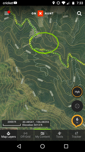
2) What do these circles mean? They are in a few spots for me when I zoom in, and they don't seem to be a layer.