Leupold BX-4 Rangefinding Binoculars

Scouting the Unlimiteds?

geetar

Well-known member
Joined
Jan 28, 2019
Messages
3,587
Location
North Carolina
I’m trying to a mid to late summer scouting trip to the unlimited sheep units this year. I started putting my name in the hat for sheep tags in other states but didn’t buy this one yet because I want to go on a backpack scouting mission and see how I like it and see if I’m up to the task of hunting sheep in the Beartooths before I spend $1250 on a tag. With that being said I have a few questions? How rugged are the roads to get to the trailheads? Reason being I have a 4x4 Jeep but I can cut travel costs way down if I could get to the trailheads in my gas saving car. Also do you guys know of any maps that available that show decent road and trailhead access? I have hunt planner maps from Montana Fish and Game website but the just show basic topography and not roads or access points.
 
Most trailheads are not bad, unless it snows. Couple trailheads you will absolutely want 4 wheel drive, chains, ect. Get good topo maps of the area. Sure you can buy them online somewhere. Good idea on taking a test run first. Bring a fishing pole!
 
Thanks for the advice. I’ll check with MyTopo I’ve got maps there before and a fishing rod is definitely in the plan.
 
The road south of McLeod along the Boulder River gets pretty bad as you approach Monument Peak. That would be HD 500. Access to most everything else in 500 and 501 is good if you're coming from the north. I'm not really familiar with road conditions out of Cooke City.
 
The road south of McLeod along the Boulder River gets pretty bad as you approach Monument Peak. That would be HD 500. Access to most everything else in 500 and 501 is good if you're coming from the north. I'm not really familiar with road conditions out of Cooke City.

I pulled a horse trailer up that road for my mountain goat hunt many years ago. Good Lord. I didn’t know the many washboards existed.
 
I pulled a horse trailer up that road for my mountain goat hunt many years ago. Good Lord. I didn’t know the many washboards existed.

I worked at one of the summer camps on the Boulder when I was in college and we'd pile in the beds of pickups and drive down to hike Monument...we never had anyone go overboard but came close a time or two😀
 
If you plan on late summer you really should be able to access any of the trailheads. There's a couple that I wouldn't take anything less then a 4 wheeler. I would look at the Boulder or maybe Cooke bring a heater (griz city) and a rod. Those two points will probably put you into "sheep" country quicker than say West or the Stillwater. During that time of the season you'll need to spend a good day or more to even get to where you want to start looking for sheep. Your in for a great hike either way and if you haven't spent much time in the tooths you'll realize the unfathomable size of country your going to be attacking come go time. Good luck.
 
Thanks EYJONAS. That’s the kind of info I’m looking for. I just wanna go out there and get my boots on the ground and just get a feel for the country for the first time. That way I will know more firsthand what to bring and what will work good when I do buy the tag.
 
Also what kind of fish inhabit these mountain lakes that I would be fishing on this scouting trip. That way I’ll kinda know what to bring. I’m familiar with fishing for mountain trout and smallmouth bass here in the NC mountains but I’ve never fished out there.
 
Here's the Forest Service interactive map you can zoom in on.

From my own experience I would not take a car down anything less than the "Gravel Road Suitable for Passenger Cars". I've been on some of those rated as "Dirt Roads Suitable for Passenger Cars" that I had to crawl slowly up in granny low gear 4x4 with my full-size F-150 and was still scraping the frame or skidplate in spots and wallowing through mudholes deep enough to push a bow wave with the bumper.

Depending on where you go, Pat Marcuson's book Fishing the Beartooths includes some info on roads, trailheads and trail conditions, or suggests the best route in to some of the lakes.

Yeah, it's a pain to pack in, but looking for sheep I'd take a good spotting scope and tripod.
 
Also what kind of fish inhabit these mountain lakes that I would be fishing on this scouting trip. That way I’ll kinda know what to bring. I’m familiar with fishing for mountain trout and smallmouth bass here in the NC mountains but I’ve never fished out there.
Brookies and cutts mostly. Occasional golden, rainbow, or grayling. Flies or spinners. Bare hook will work for the hungry brook trout. Get Pat's book on fishing the beartooths. Great resource.
 
Thanks for the replies guys. I found that book about fishing the Beartooths on Amazon. Looking forward to seeing what it has to offer. Also I’ve heard some guys mention using satellite phones and some mention using GPS with communication capabilities in the backcountry to check quotas and weather and stuff. What do you guys recommend?
 
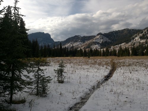
On your scouting mission, don't rule out a little jellystone recon. This nice mountain meadow is only a couple trail miles from a paved parking lot. Top of this ridge is a unit boundry.DSC01364.jpg
 
Thanks for the replies guys. I found that book about fishing the Beartooths on Amazon. Looking forward to seeing what it has to offer. Also I’ve heard some guys mention using satellite phones and some mention using GPS with communication capabilities in the backcountry to check quotas and weather and stuff. What do you guys recommend?

Get an Inreach.

Sat phones drop calls, and get static and are frustrating. Written text from an inreach says what it says and attaches a GPS Coord to it. There’s nothing to interpret.
 
Get an Inreach.

Sat phones drop calls, and get static and are frustrating. Written text from an inreach says what it says and attaches a GPS Coord to it. There’s nothing to interpret.
I felt like an Inreach was gonna be the way to go. Thanks for confirming that.
 
I’m trying to a mid to late summer scouting trip to the unlimited sheep units this year. I started putting my name in the hat for sheep tags in other states but didn’t buy this one yet because I want to go on a backpack scouting mission and see how I like it and see if I’m up to the task of hunting sheep in the Beartooths before I spend $1250 on a tag. With that being said I have a few questions? How rugged are the roads to get to the trailheads? Reason being I have a 4x4 Jeep but I can cut travel costs way down if I could get to the trailheads in my gas saving car. Also do you guys know of any maps that available that show decent road and trailhead access? I have hunt planner maps from Montana Fish and Game website but the just show basic topography and not roads or access points.
When are you looking at going? I was thinking the same thing for this year. Maybe we could go together?
 

Forum statistics

Threads
111,219
Messages
1,951,458
Members
35,081
Latest member
Brutus56
Back
Top