goHUNT Mobile Maps comments sought in this thread

Big Fin

Administrator
Staff member
Joined
Dec 27, 2000
Messages
16,529
Location
Bozeman, MT
Many of you got the iPhone version of the goHUNT's mobile maps in the last week, as a part of your INSIDER membership. They waited to roll out mobile maps until it was at a great starting point. My crew, all iPhone users, has been helping with beta testing for the last three months.

I'm one of those Droid users, so I just got my first version last week. I suspect the INSIDER members will be getting the Droid option very soon.

Now that the mobile map app is in the hands of many users, goHUNT has asked me to use Hunt Talk as a place to gather comments that any of you have. This is not a thread for questions. That will come at a different time. For now, they want your comments for improvements or anything you want done differently so they can take all those comments, sort them, and be responsive to user needs and ideas.

If you post a comment or suggestion in this thread, I will forward those to goHUNT. Thanks in advance for any feedback.

Or, you can leave comments on their site at this link - goHUNT Mobile Maps link


P.S - As always, if you do sign up, promo code RANDY saves you some dough ($50 gift card).
 
When using the search function to find a specific location, goHUNT maps doesn’t make it clear where exactly the spot you just searched is and doesn’t hold it centered as you zoom in.
 
One thing I’ve noticed is some of the satellite imagery is pretty rough I’m focused on NV and because of the time of year the photo was taken (winter) with the snow it’s super hard to see any detail, depth and also what the canopy is so I have to go back and forth to google maps to see what the landscape actually looks like. Would be nice if you had two imagery selections like a spring and fall. To really know what the landscape is. Or maybe just finding these snowed out images and using a different pic of the area.
 
I sent Lorenzo a comment last week on making the property lines contrast adjustable and on the top layer. They are so hard to see now with any other layer on. I was pretty surprised to get a response back the next day. I appreciate them taking it off the shelf last year and working to get it right before season this year. Hats off to them.
 
Product development feature request: Stop having to login every single time you switch out of the app. There should be a remember me option.
They replied to me that this was a small login issue not relate to the map app that was occurring last week and should now be fixed.

Thanks for the comments many are providing. Continuing to send them along, so please keep posting them.
 
Setting up for a scouting trip this weekend and went to download some offline maps. Quickly set up three adjoining high res maps and clicked download on all three. Five hours later they hadn't completed so I shut down the app and downloaded them one at a time within a few minutes. Not a major concern, but good to know if you planned to download several areas.
 
Setting up for a scouting trip this weekend and went to download some offline maps. Quickly set up three adjoining high res maps and clicked download on all three. Five hours later they hadn't completed so I shut down the app and downloaded them one at a time within a few minutes. Not a major concern, but good to know if you planned to download several areas.
Tried to use the GoHunt Map on my iPhone this weekend without any success. As mentioned earlier, I downloaded the maps and then went off for a long weekend of exploring and scouting. Tried to start the app several times, both with a 3G connection and with the phone in airplane mode. Could never get logged in and couldn't figure out a way to use my offline maps without logging on and authenticating. I'll watch some of their videos tonight, but sure seems like the process should be more intuitive.
 
The biggest thing i see missing is that if i tap on a property, trail, burn, etc. no info comes up like it does in OnX. I didn’t realize how much i used that feature until it was missing. Maybe im just doing something wrong. Also, trail types need to be clearly marked like they are in OnX. Hard to tell if trails are ATV, dirt bike, or foot only.
 
So this weekend used offline maps for a scouting session. I started my trek up the mountain got to my first spotting location after about a mile and a half paused it and scoped for about 35 min. Opened map back up and hit restart closed my phone I went another mile and went to look at my phone. The app restarted while offline I didn’t have to log back in but it reopened and my track was gone along with two points I had saved. Started a new trek and for a while it said I had gone 233207miles at 6.6mph lol. Don’t know what can be done for offline work but there’s definitely a few tweaks that would help. Curios as to why it would restart when offline shouldn’t it be working completely independent via downloaded content? So I’m unsure why it would restart?
 
The Onx topo holds the topo lines from topo to hybrid as you zoom in and out. The merge of the topo lines is almost seamless.

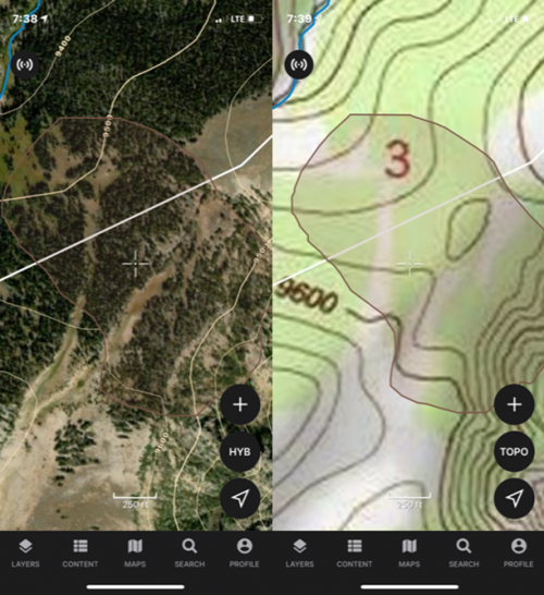
I like the scanned copy of the topo layer in GoHunt especially since detail fluctuates depending on your zoom level. However, the line detail does not have a seamless transfer to the hybrid layer. At the same zoom level, here is a snapshot of a saddle:
1625014252791.png
 
Second, I like Onx's Roadless layer. That purple-white heat map is awfully pretty. Can't Gohunt do this and just make it orange or another suitable color?

I like that the roads are now neon green, it's subtle but seems to be much more helpful. I have resorted to clicking on and off the layer as I move the map so I can see the difference between trails and motorized roads.

Third, can you get a buddy tracker so you can see where your partners are using satellite sync.

4th: Is there a way to import the Google satellite and terrain maps into GoHunt app?
 
5th... as part of number two above, if GoHunt can't do number two, what if they were to create the opposite; a 'Road-Full' layer instead of a roadless layer... this could be better than Onx's purple roadless layer..

think about it, if you did the opposite by filling in all the areas close to the roads, you end up with the areas distant from roads that aren't colored in. In these areas, for our benefit, we can now actually see the terrain and everything else we want to look at without having to switch the purple colors off.
 
Ollin Magnetic Digiscoping Systems

Latest posts

Forum statistics

Threads
110,816
Messages
1,935,414
Members
34,888
Latest member
Jack the bear
Back
Top