East Crazy Mountain Land Exchange

In this recent proposal they threw in Smeller Lake. That's hardly a crumb.
I understand that. It's good for public lands, but really not a big deal to Cross Harbor.
The swap deal is likely the best we'll get and after decades of trying to access the Crazies ... however, it should not be that extremely difficult to access and use our public lands.
Whoever came up with that checkerboard incentive and drive to settle the west probably had no idea of the future huge impacts.

The deal ... yeah, let's get USFS to take it and make public use of the increased access. But I would rather the Crow tribe still had the circle of power around the Crazies than a bunch of money hungry folks, many of whom don't give a rodent's a$$ about Montana and her special places.
Is it really the best deal? Could you not hold the great lands the public owns, not cede the public trails to the landowners and negotiate a better and more equitable deal?

This proposal assumes the public owns nothing and is owed nothing and its being sold as a generous offer from the landowners and YC. I disagree wholeheartedly with that position. Once we trade those lands and abandon the current trails, they will be gone forever.
 
If all of the public lands to be traded away were first covered with a conservation easement I'd support it.
Thanks for reminding me. That was another thing that was expected, but didn't make it to this draft. Conservation easements are a legitimate ask, and they were done in the south crazies. It's really important to say stuff like that in any comments rather than make it conditional on something unrealistic.
 
Is it really the best deal? Could you not hold the great lands the public owns, not cede the public trails to the landowners and negotiate a better and more equitable deal?

This proposal assumes the public owns nothing and is owed nothing and its being sold as a generous offer from the landowners and YC. I disagree wholeheartedly with that position. Once we trade those lands and abandon the current trails, they will be gone forever.
John, I get that idea, I really want to support that idea, but what keeps me from wholeheartedly being against this swap is that I haven't heard of any other solutions. There appears to be no effort to sue land owners for access, we can't buy them out because someone has to be willing to sell in order acquire (even if we do have considerably more money available through LWCF), I don't know of any other options to address this. It seems the longer it hangs out there the less leverage we as the public have. The only potential leverage I can see is to gain access via corner crossing or simply annoy the shit of the landowners with trespassing and heli flights into the isolated sections, both of which may do more harm than good.
 
John, I get that idea, I really want to support that idea, but what keeps me from wholeheartedly being against this swap is that I haven't heard of any other solutions. There appears to be no effort to sue land owners for access, we can't buy them out because someone has to be willing to sell in order acquire (even if we do have considerably more money available through LWCF), I don't know of any other options to address this. It seems the longer it hangs out there the less leverage we as the public have. The only potential leverage I can see is to gain access via corner crossing or simply annoy the shit of the landowners with trespassing and heli flights into the isolated sections, both of which may do more harm than good.
I understand your position but ask what solution does this proposal provide? Is a singular access point with a 22 mile trail better? Imagine the congestion. Is the swap of high-value low country lands for steeper less productive lands better? Is the loss of the last public sections on lower sweet grass creek worth the consolidation of green squares on a map? Don't get me wrong, the proposed consolidation of public lands is great but not all green squares are the same. The public can reject this proposal and remain in the status quo, we keep our current quality sections and trails and retain the option to establish our access rights (easements, corner crossing, utilize LWCF, etc.). Then we can negotiate from an equitable position and look for an equitable deal. If we accept this as is we lose those lands and trails forever. As is now, I view this proposal as a solution for the problems of only one side of this deal. There are serious efforts looking at all options.
 
I understand your position but ask what solution does this proposal provide? Is a singular access point with a 22 mile trail better? Imagine the congestion. Is the swap of high-value low country lands for steeper less productive lands better? Is the loss of the last public sections on lower sweet grass creek worth the consolidation of green squares on a map? Don't get me wrong, the proposed consolidation of public lands is great but not all green squares are the same. The public can reject this proposal and remain in the status quo, we keep our current quality sections and trails and retain the option to establish our access rights (easements, corner crossing, utilize LWCF, etc.). Then we can negotiate from an equitable position and look for an equitable deal. If we accept this as is we lose those lands and trails forever. As is now, I view this proposal as a solution for the problems of only one side of this deal. There are serious efforts looking at all options.
First off, you're talking to someone in WA about congestion... LOL

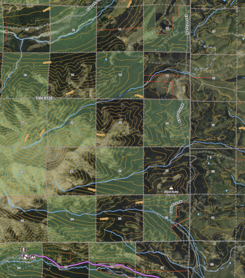
Secondly, right now I can't legally (easily) access sections 14 or 26. Both of which have some elky terrain. So this proposal gets me access to 1,200 acres that I currently can't access.
1669162991793.png
Plus, lets get real, I can't really access any of that checkerboard right now. It's not in my acceptable risk circle, so as of right now, I'm not getting any benefit out of 12, 24, or 36, so I'm not really losing anything tangible. Unless I hit Powerball I doubt I'm hiring a helicopter anytime soon.
 
First off, you're talking to someone in WA about congestion... LOL

Secondly, right now I can't legally (easily) access sections 14 or 26. Both of which have some elky terrain. So this proposal gets me access to 1,200 acres that I currently can't access.
View attachment 251731
Plus, lets get real, I can't really access any of that checkerboard right now. It's not in my acceptable risk circle, so as of right now, I'm not getting any benefit out of 12, 24, or 36, so I'm not really losing anything tangible. Unless I hit Powerball I doubt I'm hiring a helicopter anytime soon.
You can’t land a helicopter on FS land anyway.

Of what you’ve shown, all you can reasonably access now is sections 2 and 34 at the bottom. You can get to 10 (and 8, which is not shown) at the top from the west, but it’s about a 20 mile walk iirc.
 
I spoke with FWP's Region 5 elk biologist about HD580 (that is the HD where the proposed land exchange will occur). He confirmed what already know: The public is losing the best elk habitat in this exchange. He was very careful not to take a position on the exchange. The fact is the exchange asks the public to trade productive low-country public parcels for steeper high-country private parcels. Elk generally prefer the low-country land where there is shelter, food, water and living is easy. This distribution is backed up by FWP's aerial surveys.
The bolded statements are mildly misleading. The public sections represent the best winter range habitat, as is evidenced by the aerial surveys which are conducted in late winter when elk are concentrated on winter range and more easily observed. The higher elevation areas (both currently public and proposed to turn public) are excellent summer range habitat for elk. Elk are present in this area at high elevations until snow pushes them down to the aforementioned winter range habitat.
 
The bolded statements are mildly misleading. The public sections represent the best winter range habitat, as is evidenced by the aerial surveys which are conducted in late winter when elk are concentrated on winter range and more easily observed. The higher elevation areas (both currently public and proposed to turn public) are excellent summer range habitat for elk. Elk are present in this area at high elevations until snow pushes them down to the aforementioned winter range habitat.
sclancy27, Justin and I spoke big picture stuff and never discussed summer range vs winter range, therefore I did not mention those details in this HT thread. I asked specific questions about the lands being swapped (is there water, forage, etc.). He was very cautious and clear not to take a position on the swap but also made it clear the lower country stuff we lose is much better elk habitat. He confirmed to that through aerial surveys the elk congregate on the lower country lands, which are likely the winter surveys mentioned. I looked up the elk populations numbers on the FWP site. I'm not questioning your comments on the summer range vs winter range, but Justin and I did not get into those details. Certainly no intention to mislead on these discoverable facts. Thanks for adding that clarity.
 
The bolded statements are mildly misleading. The public sections represent the best winter range habitat, as is evidenced by the aerial surveys which are conducted in late winter when elk are concentrated on winter range and more easily observed. The higher elevation areas (both currently public and proposed to turn public) are excellent summer range habitat for elk. Elk are present in this area at high elevations until snow pushes them down to the aforementioned winter range habitat.
Haven't we had multiple threads discussing how much public hunting pressure is pushing elk down to the low country/off public land before the snow can do so? I know of several areas in the crazies where elk are hanging out in the low country far before the snow arrives. Anecdotal for sure, but I think your post is misleading in that it makes it sound like all the elk just hangout on public until the snow forces them to leave, regardless of other factors. Snow is not the only determining factor for why the elk are where they are.
 
Haven't we had multiple threads discussing how much public hunting pressure is pushing elk down to the low country/off public land before the snow can do so? I know of several areas in the crazies where elk are hanging out in the low country far before the snow arrives. Anecdotal for sure, but I think your post is misleading in that it makes it sound like all the elk just hangout on public until the snow forces them to leave, regardless of other factors. Snow is not the only determining factor for why the elk are where they are.
I am very familiar with that area, so I spoke from experience. Yes, there are elk on private, but there are a large number of elk that use the high elevation areas before and during hunting season. I only wanted to point out that as this is not a HD 535 scenario (or for example, the west side of the crazies along Cottonwood Cr and previous 'Marlboro Ranch'), where elk on private to public is much more skewed. I think in determining whether this is good deal for public land users and sportsman we need to be specific to the actual area in question.
 
Another good article from Amanda at Montana Free Press

Forest Service unveils Crazy Mountains land swap proposal​

https://montanafreepress.org/2022/1...x3CYmmeP0bQyKSJHFko5vlZ_UhOgi59tyfOfeQ62k7jzw

There is a lot of good information in Amanda's piece but one thing was struck me was this...

"Meeting attendees also flagged concerns ... and asked the Forest Service whether the traded parcels in the Crazies are equivalent in terms of streams and wetlands. Forest Service fish biologist Clint Sestrich responded that the agency is working through available data on area wetlands in the areas proposed for exchange to pair with on-the-ground observations the agency hopes to get next summer in order to ensure there is no clear deficit."

There is clear regulation which disallows the USFS from generating a net loss of wetlands in a land exchange. In order to meet this requirement the USFS needs to equalize all the wetlands along any stream course or water body that it would be losing. This regulation exists for many good reasons, including to prevent corrupt bureaucrats from giving away our streams and lakes.

The Inspiration Divide Land Exchange EA claims wetlands on public equal roughly 54.2 acres and the wetland on private equal 7.8 acres. The exchange as is would result in a net loss of 46.4 acres of wetlands.

How can they go forward with this proposal and public comment process when they know right now it does not meet the requirements of no net loss of wetlands? The CGNF is telling us they will do more research and will let us know next summer, which of course will be way after the public process. Are they going to find more wetland that they don't already know about? What if they don't?

Seems like another example of leadership choosing to move forward in a deceptive manner to try and cram this thing through.
That is a very good article, thanks for sharing.

I am certainly leery whenever one side thinks it's a win and the other a loss. Both should probably consider it a loss or it isn't fair.

I will say that the idea of a prescriptive easement seems to be gone. Am I correct that only the FS can take that to court? They seem unwilling. And after X number of years you can lose a prescriptive easement right? So it could just be a waiting game until the public has even less leverage?
 
I apologize in advance for the long post, but this is a worthy subject. The portion of the proposal I am in favor of is the consolidation of some of the land in the Crazies, however, the benefit gained by this consolidation is not worth the cost. I am opposed to this proposal for a variety of reasons, some philosophical and some practical and ask you to join me in voicing your opposition to this proposal.

On the philosophical side (and in somewhat chronological order, not priority order) a huge part of my objection is the loss of trust in the USFS in general and the process that has led us here. In my experience, faulty process leads to faulty outcomes and this has been a faulty process from the start:
  • When this proposal was first pitched to conservations groups in Montana, the Yellowstone Club through their representatives (Tom Glass and Jess Pedersen) told the groups including me, that the Yellowstone Club had no interest in the Crazies themselves, but were told by the USFS that the USFS would not be able to act on an unrelated swap on behalf of the Yellowstone Club unless the Crazies were solved. This has turned out to be untrue, as we now know, the Yellowstone Club has specific interest in the Crazies.
  • The underpinnings of this proposal have their origins in closed door meetings that the public was excluded from (improperly as it turns out since the USFS was also in attendance) unless they were approved by the landowners themselves.
  • The USFS believes they have valid prescriptive easements up both trails being lost in this swap as indicated in the letter posted earlier on this thread. I have seen objections to that view on these posts as the letter being outdated, I believe this to be false. There is an internal memo that the USFS themselves dated nearly 2 years after that letter affirming this belief and the USFS Deputy Chief French testified under oath on direct examination from Sen. Martin Heinrich that the USFS had not changed their position on these trails. Those in litigation have sought documents evidencing a reversal and have been told there are none. If there is evidence to the contrary, I would love to see it as it would be particularly useful in the current litigation.
  • The USFS noted in letters to Senator Daines that the landowners were illegally obstructing these trails (in the same letter above). These are the very same landowners that benefit the most from this current proposal. Keep in mind, one of them is the person who did this to a member of the public accessing what the USFS has said is a public trail. This has become the playbook of landowners in Montana and we shouldn’t reward illegal behavior.
  • 1669247215968.png
  • I have strong suspicions that those groups (other than the Yellowstone Club) who are supporting this proposal have received direct or laundered funding from the Yellowstone Club. Not illegal, but potentially worthwhile information from those seeking to decide how they feel about this proposal.
  • Those advocating for this proposal have repeatedly said that the public is losing nothing up Sweetgrass creek. As we now know, this has also turned out to not be true. This falsehood is still listed on their website as a “myth” in spite of the clear evidence shown on this very thread of the USFS abandoning the public’s interest in these trails. Check it quickly before they take it down. I don’t think “myth” means what they think it means.
  • On the west side, the USFS opened up a proposal for comment until the negative comments came in, at which point the closed the process down and instead have relied on a 10-year-old vague analysis to support not needing current public input. This does not engender trust.
  • Advocates for the swap publicly misstated conservation and access groups support for this swap.
  • In the current litigation, the USFS acknowledged in court that they have stopped removing the illegal obstructions, and instead are intending to rely on this land swap. In fact, the USFS suspended the employee who removed these illegal obstructions. This does not serve the public’s interest or public trust.
  • I reached out to Senator Tester’s office and learned the Yellowstone Club (Same two consultants noted above) approached Sen. Tester years ago and sought a potential legislative solution and were told, no, they needed to go through a public process via the USFS which has led us here. Do not fall for the “local grassroots solution” narrative. This has come from the Yellowstone Club from the start.
  • The timing of this. Dropping the proposal during hunting season, the day after the election and cutting off comment 2 days before Christmas with Thanksgiving in between. If I wore a tinfoil hat, I would say there is no window of time in which you are likely to receive fewer public comments. This does not strike me as accidental.
Philosophically, we all (at least those of us on a public hunting website) lament when the instruments of government are bent to the will of the wealthy at the expense of the everyday citizen. Although the area is different, the approach and the flawed process is the same as the Holland Lake example. The USFS does the bidding of the wealthy, misleads the public, then got caught, then tried to reverse engineer a process, but the trust has been lost. This process has been eerily similar. In Montana this has become severely aggravated over the last few years as has been documented on innumerable hunt talk threads. At some point, we have to stand for something and I cannot look Jim Posewitz’ granddaughters in the eyes and tell them their dad is the one who sold them out.

In addition to my philosophical objections, I have some specific objections. At first blush, while I favor the concept of consolidating land, the consolidation is not worth the cost.
  • The public forever loses claim up Sweetgrass Creek.
  • The public exchanges two lowland public (or disputed – this distinction is meaningless, don’t fall for it) trails in exchange for one high elevation trail.
  • The public trades low lying habitat for higher elevation habitat. My suspicion is between the snow and early public hunting that the bulk of elk will retreat to the now private lower landscape and not return during hunting season.
  • The wetlands analysis has been done twice and in each case the public is on the short end of the stick, so they are ordering a third analysis next year. It appears we are expected to trust that the Yellowstone Club dollars will remedy strike one and strike two of this analysis.
  • Leading Conservation groups (BHA, MWF and PLWA at a minimum) issued conditional letters of support for this deal and almost none of the conditions have been met (Sweetgrass Creek access, Conservation Easements, Right of First Refusals, etc). This is essentially saying thanks for the comments but we are rich and the public can screw off. It will be interesting to see who holds the line (Looks like PLWA already did, so a tip of the cap to them) and who caves to the cash.
  • The proposal is a take it or leave it proposal. Typically, this type of proposal has multiple options, not this one, only one choice is being presented to the public.
For those who took the time to read this thank you. Between the philosophical objections as well as the practical list, I urge everyone to oppose this swap.

I appreciate the complexity of the issues and the challenges and for me, this proposal is simply not good enough. It does have some good things but is not better than the status quo and doesn’t make this a good deal. If we don’t demand better from the USFS, we will keep getting worse. Please join me in opposing this fatally flawed proposal.
 
That is a very good article, thanks for sharing.

I am certainly leery whenever one side thinks it's a win and the other a loss. Both should probably consider it a loss or it isn't fair.

I will say that the idea of a prescriptive easement seems to be gone. Am I correct that only the FS can take that to court? They seem unwilling. And after X number of years you can lose a prescriptive easement right? So it could just be a waiting game until the public has even less leverage?
No, groups like BHA or PLWA can take them to court.

After five years you can lose a prescriptive right on a trail. However, the first few miles of Sweet Grass “trail” are actually a road that ends on public land at Eagle Park. The rules for roads are different than trails. As I understand it, if you can prove in court that public money was used to maintain the road in the past, then the road is public regardless of time passed, permissive use, etc.
 
Last edited:
Andrew, there is so much untrue in your post I can’t respond to much of it, but your observations like this
  • I have strong suspicions that those groups (other than the Yellowstone Club) who are supporting this proposal have received direct or laundered funding from the Yellowstone Club. Not illegal, but potentially worthwhile information from those seeking to decide how they feel about this proposal.
really show your true colors. Sadly, most of the names opposing this swap are implying or directly saying the same thing, which is not a surprising since you are all part of the group that filed the baseless suit against the Forest Service regarding the trails here.

I’ve been involved in this from the start, which was way before you, and way way before Yellowstone Club was involved. It’s always been the same people working towards a solution, and the same people trying to prevent one using misinformation such as what is displayed throughout your post. Nobody was bought when YC got involved.

Conveniently, you and everyone else fail to provide any evidence to support your accusations against YC, nor do you even present a theory of what nefarious action they plan to do.

The truth is that the YC is trying to add some public value to the Crazy Mountain swap to make their exchange in Big Sky worthwhile enough for the FS to pursue.

To add this value, the first thing the YC tried was offer to buy an easement for the public for Sweet Grass trail from the landowners. The landowners refused, which is hardly something you would do if you were getting in bed with them.

Now the YC is offering to pay for the new trail as to add the value needed. In addition, the Crazy Mountain Ranch recently decided to transfer Smeller Lake to the public (CMR has close ties to the YC).

All that said, we do need to speak out with specific and helpful comments to the Forest Service regarding the problems with the current proposal so they can be modified.

These things include not giving up rights to the SG trail without due diligence, which was part of the original proposal. I will also add that giving up the NE corner of S14 should be taken off the table. But if all you do is complain about Daines and the YC then these important details will be missed.
 
Last edited:
Can we agree on a set of facts present in this land swap? For instance, as I see it:

1. The land swap will consolidate both public and private holdings in the area, removing the "checkerboard" nature currently existing.
2. The land swap will be "acre for acre", the same amount of land will exchange between public and private holdings
3. The "quality" of the exchanged lands is up for debate, some further data gathering will help make this more clear (fisheries and wetland data) hopefully
4. The currently "checkerboard" public land has little or no public recreation value as there is no clear (or objectively legal) way to access said sections. The value of the land to the FS has not been evident (at least to me) as far as harvestable timber, etc. One could argue (and I would be one to make the argument) that the checkerboard nature is much more beneficial to the private landowners in the area as they have the ability to utilize those sections of public land for business purposes (cattle grazing, outfitting) without pressure from public access.
5. The main sticking point is access from Sweetgrass Cr. USFS does not want to fight for this access (historical use trail or road) within the parameters of the land swap, as they believe this will jeopardize the private landowner's involvement in it. BHA and other parties would be behind the swap if the access issue was cleared up as a process of the swap.
6. The land access issue (historical use trail or road) could be addressed after the swap or at any time by any entity with the funds to pursue it legally (?, this is how I understand it)

Am I missing anything or have anything just plain wrong?
 
As I understand it, if you can prove in court that public money was used to maintain the road in the past, then the road is public regardless of time passed, permissive use, etc.
Does proof of historic use for commerce also come into play? Or is it just public money being used for road maintenance?
 

Forum statistics

Threads
110,805
Messages
1,935,124
Members
34,884
Latest member
Irish-Jay
Back
Top