From: Tanja Fransen [mailto:[email protected]]
Sent: Thursday, December 11, 2008 2:55 PM
To: _NWS WR GGW EML
Subject: Special Weather Notice
Hi all,
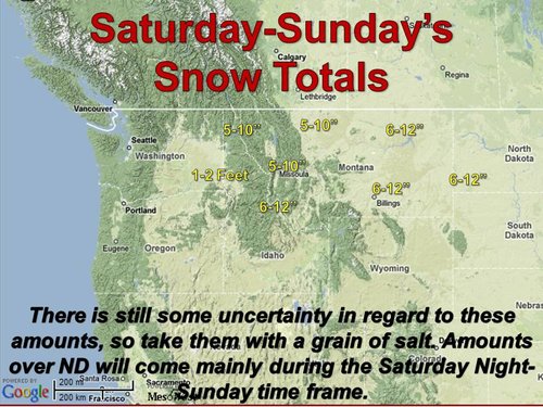
No newsletter this time around, just a heads up that this storm this weekend is going to be a big one. Snowfall totals of 7-11 inches will be common throughout NE Montana, with some areas possibly seeing up to 12-14 inches (mainly Phillips, Petroleum, NW Garfield, and perhaps the Big Sheeps and Larb Hills).
The cold front will be moving through the region on Saturday morning. The winds with this system will be pretty significant as well (NW 25-40 mph gusting up to 55 or 60 mph), causing blizzard conditions, and snow drifts measured in feet. The snow should end by Sunday morning.
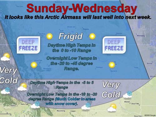
The winds will be less on Sunday, but the colder temperatures will keep wind chills pretty low. We'll see lows of 20 to 30 below on Monday morning and again Tuesday morning with highs on Sunday and Monday in the 5 to 15 below range.
You can keep up on the latest forecast and conditions from your area by going to http://www.weather.gov/glasgow.
If you have outdoor or travel plans this weekend, it would be really good to reconsider those, and stay home, read a book, catch up on movies, or play a game with the family. Those are my plans (and to clean the inside of the refrigerator!). ;-)
Tanja
--
Tanja Fransen, Warning Coordination Meteorologist
NOAA's National Weather Service Glasgow
101 Airport Rd.
Glasgow, MT 59230


")
