PEAX Equipment

Dams That Never Were

Nameless Range

Well-known member
Joined
Jun 6, 2013
Messages
5,786
Location
Western Montana
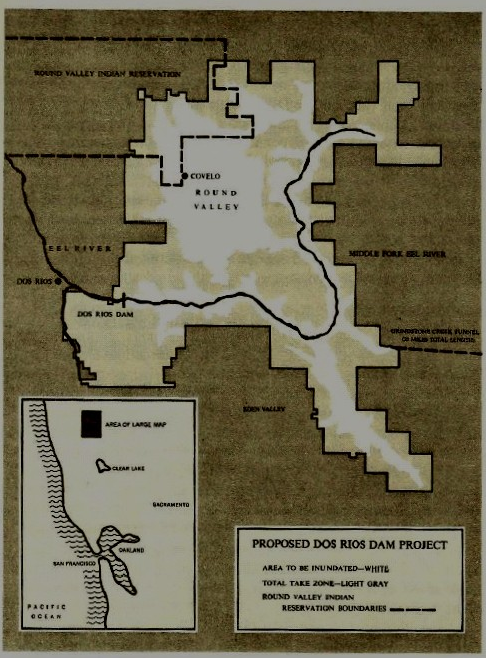
HuntTalkers who are friends with me on The Facebook have already seen these, but a kick I have been on since Big Fin made the film The Dam That Never Was is mapping out the footprints of lakes that would have existed had proposed dams been built that never were.

Though some dams had better chances than others, in almost every case conservationists stood up for the land and the rivers and voiced opposition. Using data about the proposed dams heights and other information, we can use the contours of the land to infer the inundation areas.

I've got a pile more to do, and will post them here as I go. I think they make for interesting stories of conservation.

1594306723692.png
 
Last edited:
Reichle Dam was a proposed dam in the mid 1960's, on the Big Hole River, just downstream from Glen. It's chief purpose would have been to provide irrigation for Jefferson, Madison, and Broadwater Counties.

It was controversial in its time, and folks stood against it, and I appreciate the 1964 Montana Fish and Game Commission's stand on the proposal when they wrote:

"There are only 410 miles of blue-ribbon free flowing streams remaining on our stream classification map. They are of national as well as statewide value. In fact, Montana is unique in having a considerable share of the finest trout streams left in the nation. They are a heritage in our trust."

You can read that document here: https://myfwp.mt.gov/getRepositoryFile?objectID=45801

Mike Mansfield's take on it was also interesting: https://mtmemory.org/digital/collection/p16013coll41/id/690/


1594306754720.png
 
The Paradise Dam Project was a proposed dam on the Clark Fork River put forth by the US Army Corps of Engineers in the 1940s. It would have been 250 feet high and just downstream from the community of Paradise.

In the book, “High Dams and Upstream Storage”, in support of the project, Milton C. Mapes Jr, who at the time was staff counsel of the Senate Interior Committee, wrote, “This bill offers more for Montana as the site of a Project than any bill I have ever seen.” His essay in support of the project is fascinating, and is a counterpoint to the well-known and revered Montana biologist, Dr. John Craighead's concerns.

You can read it here: https://bit.ly/2Y8o8G6

That dam had hope, but large public and even industry opposition killed it. It would have flooded the towns of St. Regis, Dixon, Superior, and Paradise – requiring the evacuation of nearly 3,000 people. It would have backed water up to Flathead Lake – there would be no Flathead River below what at the time was Kerr Dam.

The polygon you are looking at is 57,000 acres in size. The Army Corps of Engineers report said it would be 66,000 acres in size, so I am likely underrepresenting it. That would have made this the 3rd largest waterbody in Montana behind Ft. Peck Lake and Flathead Lake.


1594306799699.png
 
In the name of flood control, Glacier View Dam was a proposed project that had its best chance in the 1940s. It would have been a 416 foot tall dam that backed the North Fork of the Flathead River up into Glacier Park on the east side of the reservoir and private and public lands on the west. Due to extreme pushback from conservation organizations and the National Park Service, it was abandoned as an idea in 1949.

The revered Mike Mansfield was probably its greatest proponent. Once saying the dam, “"Would not affect the beauty of the park in any way but would make it more beautiful by creating a large lake over ground that ... has no scenic attraction.” In 1949 he proposed a bill that sought immediate authorization and construction of Glacier View Dam, but it did not succeed. Researching the dam made for some interesting reading. Folks were certain the Columbia River would wipe towns off the face of the earth if we didn’t cover the entire drainage in dams. In some instances they were right. At the same time testimony was being heard in congress regarding the dam, Oregonian staff writer Leverett Richards wrote, “"Old Man River has a hump on his back like a mad buffalo and he’s stampeding all over the place.”

There is a chance I am over-representing the lake here by 30 – 40%. I know the location where the dam was to be built. And I have a report that says Logging Lake would have increased in depth by 50 ft. On the other hand, I have a report that says the impoundment would have been about 50 sq miles in size. Due to topography, both cannot be true, but I am also using a rough digital elevation model, so I have settled somewhere in between. The polygon you see here is about 80 sq miles in size. Either way, Polebridge, numerous ranger stations, and what is now a wild and scenic river, would’ve been inundated


1594306846388.png

GlacierViewTopoResize.jpg
 
Last edited:
I learned of one in my "backyard"

As it courses tamely through a scenic North Coast canyon, the Eel River today gives no hint of its violent past nor the ongoing battle over its waters, which are literally divided between two regions.

In December 1964, warm rain falling on winter snow transformed the Eel — which flows hundreds of miles from Lake Pillsbury in Lake County to the coast near Fortuna — into a torrent that took 24 lives and wiped away bridges, railroad tracks and homes.

The flooding, combined with Los Angeles' relentless thirst, led to plans for a 730-foot dam on the Eel's Middle Fork at Dos Rios, igniting one of California's epic environmental battles.

Water impounded by the dam would have flooded Round Valley, including the town of Covelo, and ultimately been piped to the Central Valley and Southern California.

Richard Wilson, a wealthy Republican rancher in Round Valley, joined conservationists in a fight that ended with then-Gov. Ronald Reagan scuttling the Dos Rios project in 1969. The Eel subsequently won protection as a wild and scenic river.
dos-rios-dam.png
 
The Pick-Sloan Plan for the Missouri River Basin (authorized by the Flood Control Act of December 22, 1944) basically had a reservoir planned on every flowing stream in the Missouri River Basin. Many of those dams were constructed and now provide abundant recreational opportunities.

However, many (most) were not built because of the value of the resources that would have been flooded, and, I am sure, lack of funds.

ClearCreek
 
I grew up in Plains and I never knew about the Paradise Reservoir in the 40's. That would have been quite the change to that area. Actually similar to the Noxon Rapids Dam except this one would have had two huge arms in it and would have covered up a fair amount of area I spent exploring in my youth and still venture to today at times.
 
Very cool @Nameless Range . Another one to consider is the dam proposed for Spruce Park in the Middle Fork of the Flathead. That dam, along with Glacier View, were major motivation behind creating the Wild & Scenic River Act. Glacier View Dam gives me chills every time I think of it. The North FOrk has dodged a lot -- oil drills, coal mine, a federal dam, but remains one of America's great wild lands.
 
Very cool @Nameless Range . Another one to consider is the dam proposed for Spruce Park in the Middle Fork of the Flathead. That dam, along with Glacier View, were major motivation behind creating the Wild & Scenic River Act. Glacier View Dam gives me chills every time I think of it. The North FOrk has dodged a lot -- oil drills, coal mine, a federal dam, but remains one of America's great wild lands.

Thanks Ben.

I have been reading about a couple proposed locations on the Middle Fork - Spruce Park and Belton. I think those maps will be cool and I will definitely get to them.
 
Here is WA, in the heart of the liberal westside, where we are spending hundreds of millions of dollars annually on salmon restoration, we're still trying to make the same mistakes. https://www.knkx.org/post/proposed-new-dam-chehalis-address-chronic-flooding-raises-many-questions
We love ourselves some dams out here. And no matter how much money gets thrown at trying to improve conditions and passage for anadromous fish, the fact remains that as long as the dams stand, the fish will struggle to pass:
 
We love ourselves some dams out here. And no matter how much money gets thrown at trying to improve conditions and passage for anadromous fish, the fact remains that as long as the dams stand, the fish will struggle to pass:
That Pelton dam is a joke, so much money wasted on projects that were supposed to help salmon but actually made the water quality worse.
 
Dang, that would be a huge loss of winter range. People always debate the impacts on fish and animals that depend on the river, but rarely have I heard the issue of habitat loss for deer and elk raised. I can’t imagine what impact it would have on deer and elk if the entire Paradise Valley was under water!
 
Here in the SE part of the state there was a dam proposed on Powder river at Moorhead. I think it was scrapped after the engineers figured put how fast it would silt in.
There was also a much bigger dam proposed on Tongue River.

Interesting reading Nameless, Thanks for posting.
 
Here is WA, in the heart of the liberal westside, where we are spending hundreds of millions of dollars annually on salmon restoration, we're still trying to make the same mistakes. https://www.knkx.org/post/proposed-new-dam-chehalis-address-chronic-flooding-raises-many-questions

Yep for sure the longest remaining free flowing river in the state. Idiots from my county are pressing this dam. They are quite ignorant as a whole. There is important Roosevelt elk and Blacktail deer wintering habitat at stake in addition to all of the fisheries issues. The one hope here is the Quinalt Indians have come out in firm opposition. That could very likely be the end of it.
 
Caribou Gear

Latest posts

Forum statistics

Threads
110,805
Messages
1,935,062
Members
34,883
Latest member
clamwc
Back
Top