Lost Lake Trail #64

riv3rbanks

Active member
Joined
Oct 30, 2017
Messages
163
Location
Deep in the Heart of Texas
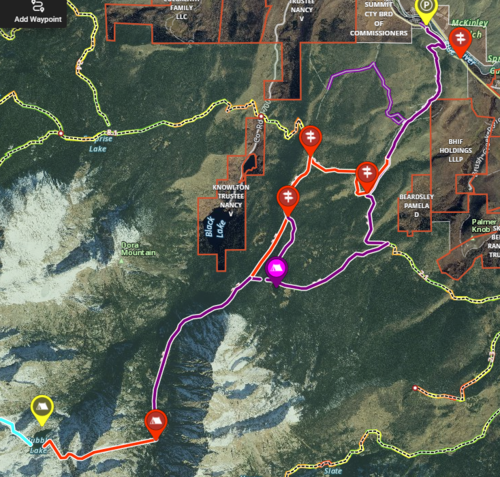
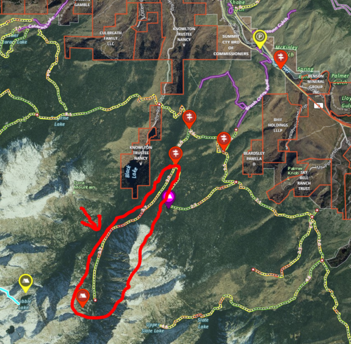
I'm looking to do a hiking trip this summer with some buddies and I was scouting on onX and Google to find some fun, less traveled trails. I came across Lost Lake trail in between Silverthorne and Heeney. It looks like a pretty easy hike and I wanted to make it a little more adventurous by adding on some additional trails and possibly going off trail a little bit. I found a trail called "South Rim Black Creek 64.1A" on onX that runs a little further west and ends. From there I was thinking about going off trail until we ran into Bubble Lake. Only thing is I cannot find any info on South Rim Black Creek 64.1A trail. I even called the Dillon ranger office and the person I talked to there had no idea what I was talking about. I'm guessing it's an unmanaged trail. Hoping to find someone on here who's familiar with this area and could steer me in the right direction. The image on the left is my proposed route. Taking the purple line there and the red line back. The image on the right is the trail in question.
105087 105088
 
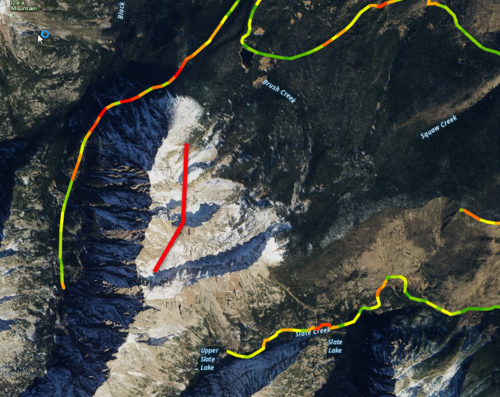
That's a hard no on your route, the slope on that side of the mt is over 50 degrees you would need ropes to even think about it going straight up it... traversing it would be impossible. Even walking the knife edge would be treacherous.

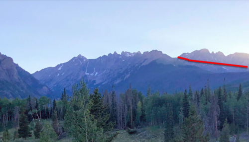
Your traverse line in red. There is a ton of beetle kill in the area... bushwhacking gets really ugly really fast.

105089
 
64.1 Isn't on the USDA quads... it probably did exist but I'm not sure on the current conditions... I've definitely run into trails back there that weren't on the map and mapped trails that really didn't exist.
Bring bug spray and maybe a head net, I've been up there with no bugs at all, but last July I tried to camp at surprise lake but it was like something out of an Alaskan horror story.

Doig lake is named after my Wife's grandfather, I've never been there but her family always comes in from surprise lake.

https://data.fs.usda.gov/geodata/rastergateway/data/39106/fstopo/394510615_Mount_Powell_FSTopo.pdf
https://data.fs.usda.gov/geodata/rastergateway/data/39106/fstopo/394510607_Squaw_Creek_FSTopo.pdf
 
Last edited:
That's a hard no on your route, the slope on that side of the mt is over 50 degrees you would need ropes to even think about it going straight up it... traversing it would be impossible. Even walking the knife edge would be treacherous.

Your traverse line in red. There is a ton of beetle kill in the area... bushwhacking gets really ugly really fast.

View attachment 105089
You're talking about my red line to Bubble Lake?
 
My photo is of this section. Your first map up to bubble lake is doable... although it might totally suck and take 3x as long as you think... might not. A bit hard to say. Generally speaking when I'm trying to get a sense of backcountry routes I use google earth and put the terrain elevation exaggeration at 1.5. That gives you a bit better of a sense what you are looking at.

105096
 
My photo is of this section. Your first map up to bubble lake is doable... although it might totally suck and take 3x as long as you think... might not. A bit hard to say. Generally speaking when I'm trying to get a sense of backcountry routes I use google earth and put the terrain elevation exaggeration at 1.5. That gives you a bit better of a sense what you are looking at.

View attachment 105096

If you look back at the second map in the first post, I think you are misreading the circle he drew around the trail in question as his route. The way I read that, he drew a red circle around a section of trail he’s asking about. I think his “out on red, back on purple” just refers to his first map.

Or he’s insane and really wants to go that way....;)
Thanks for clearing it all up for us. I could’ve done a better job explaining. I’m not quite that insane, but I’m sure I’ve done dumber things in my life.
 

Forum statistics

Threads
110,807
Messages
1,935,159
Members
34,886
Latest member
tvrguy
Back
Top