How accurate is OnX?

IDHUNTNFISH

Well-known member
Joined
Mar 16, 2017
Messages
191
Location
Middleton,ID
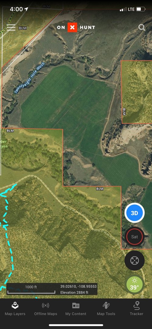
Howdy fellas, So a question for you. How much would you be willing to stake on how accurate OnX really is? The reason I ask is this. This fall I was hunting in Colorado. As you can see in the attached photo. It clearly shows that part of the "owners" ag land is marked as BLM. Then as you can see my tracks is clearly way into the BLM BUT there was a fence and gate right there that says private no hunting or trespassing. Violators will be prosecuted to the fullest extent of the law. This section of private had hundreds of deer on it. When I talked to the fish and game officer he said this ranch has a very strict no recovery policy. So If you did happen to shoot a deer on public and it did die in the yellow part of the ag land would you possibly risk your gun, truck, fines, loss of hunting privilege's to recover it?
 

Attachments

  • Screensho.jpg
    Screensho.jpg
    495 KB · Views: 179
It’s relatively accurate. But you won’t be splitting hairs on property lines. The gps in your phone or hand held is not the quality of that of a survey grade gps. So it will get you reasonably close.
 
Crap in Crap out right...

OnX get's it's data from local agencies and reconciles them with federal data. They don't hand map every parcel, further the accuracy of the blue dot is dependent on your phone.

Easiest way to confirm is to figure out which county the parcel is located in, google for instance "Delta County Colorado GIS" go to their webmap view and confirm the parcel boundary's are the same.

This still doesn't mean the county is correct, I've seen a ton of instance where they are wrong... but if the game warden is called on you, you likely won't be ticketed.

Don't jump a posted fence in that location, would be my advice. If it's not posted you should be fine.
 
I've found a lot of county rd and access points to be fairly off and to be honest if a guy is 1000 percent reliant on it for access I think he's asking himself to get into a shitty situation at some point.
 
Crap in Crap out right...

OnX get's it's data from local agencies and reconciles them with federal data. They don't hand map every parcel, further the accuracy of the blue dot is dependent on your phone.

Easiest way to confirm is to figure out which county the parcel is located in, google for instance "Delta County Colorado GIS" go to their webmap view and confirm the parcel boundary's are the same.

This still doesn't mean the county is correct, I've seen a ton of instance where they are wrong... but if the game warden is called on you, you likely won't be ticketed.

Don't jump a posted fence in that location, would be my advice. If it's not posted you should be fine.
For example the two counties I work in the most are polar opposites. One County Has parcel lines all over the place, they actually have each of them as polygons and neighboring lots wouldn't have the same lots lines, they'll cross.

vs the other county that actually maintains a GIS staff and has gone through all the old plats from the original land grants forward to bring much of their parcel data up to survey standards where possible.
I had a county in WV that had undivided interest tracks broken out with separate polygons for each owner... and they were all slightly shifted. 🤦‍♂️

Huge portions of Texas have literally nothing...
 
I agree 100% with you. In my opinion they are posting public land.
You could always pull the deed from the clerk and recorder and check. It would be pretty easy if it's all quarter calls then likely it's incorrectly posted. If the deed is metes and bounds then the county might be wrong. Why would you correct the county and make yourself pay more taxes :)
 
I was walking 100 feet inside the boundary between forest service and private in the dark according to Onx this fall. as I scanned side to side with my headlight I caught a reflection up hill of where I was by about 15 yards. You guessed it, I was on private.
 
On my phone, I trust it to be accurate give or take about 50 yards... When I've put the chip in my regular gps, it seems much, much more accurate.
 
Accuracy seems to be dependent on what county your in for onx overlay. The property I hunt in PA seems like its overlayed correctly, however the gps puts me within about 30 ft of where i am. I can tell by standing next to a lone tree in the middle of a field. Two counties over where my buddies camp is the overlay is shifted one property to the east of where it should be.
 
Accuracy seems to be dependent on what county your in for onx overlay. The property I hunt in PA seems like its overlayed correctly, however the gps puts me within about 30 ft of where i am. I can tell by standing next to a lone tree in the middle of a field. Two counties over where my buddies camp is the overlay is shifted one property to the east of where it should be.

Like the aerial is correct and the boundaries are wrong or the aerial is off?
 
Back
Top