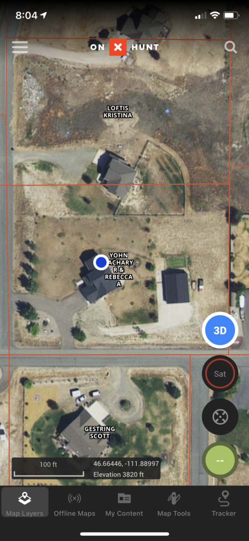
Where I hunt the property lines are correct on the aerial. At my buddies, his property is overlayed on the neighbors house.Like the aerial is correct and the boundaries are wrong or the aerial is off?
Navigation
Install the app
How to install the app on iOS
Follow along with the video below to see how to install our site as a web app on your home screen.
Note: This feature may not be available in some browsers.
More options
You are using an out of date browser. It may not display this or other websites correctly.
You should upgrade or use an alternative browser.
You should upgrade or use an alternative browser.
How accurate is OnX?
- Thread starter IDHUNTNFISH
- Start date
WyoDoug
Well-known member
On-X is close enough for general use and to get you from point A to point B and to identify most public and private areas. If you run into an established fence line that does not show on the map, I would not cross it unless you KNOW for sure it is public land. On-X is not 100% so if there is question on how a parcel is posted, consult with local authorities.
D
Deleted member 22670
Guest
To late. I got it. I’ll be there next year.Might wanna clip the lat long off your screen shot
Irrelevant
Well-known member
I would guess that where you hunt the aerial is off (quite common), and where your buddy is the both are off, but in opposite directions, exacerbating the perception of the error.Accuracy seems to be dependent on what county your in for onx overlay. The property I hunt in PA seems like its overlayed correctly, however the gps puts me within about 30 ft of where i am. I can tell by standing next to a lone tree in the middle of a field. Two counties over where my buddies camp is the overlay is shifted one property to the east of where it should be.
I've been using OnX for a couple of years now and have found it to be accurate to with about 30 yards or so. I've even talked to some of the local wardens here in Wisconsin and most of them who have OnX themselves also use it for property boundary issues as well. So far I haven't had an issue with trespassing when hunting close to private land as long as I can show the landowner the lines I hunted and that I didn't cross over.
lastlight
Well-known member
I am part owner of a unique piece of property grandfathered in among a wilderness area here in CA. I can tell you that OnX is way off, like several miles, on our property lines. We are to lazy to figure the issue out but I think it comes down to the forest service and it’s been decades since they surveyed the property. Needless to say our private property signs get stolen every year and I’m always kicking people out during deer season if I’m hunting the area.
D
Deleted member 28227
Guest
Fascinating, would you mind pm’ing me coords I want to check it out.Where I hunt the property lines are correct on the aerial. At my buddies, his property is overlayed on the neighbors house.
The aerial being off is a totally different set of issue.
R
rwc101
Guest
Property lines seem pretty accurate. Other things, like listing the I-80 rest stop as Vedauwoo rock climbing area, are less accurate.
Speeddmn
Active member
belshawelk
Well-known member
Its about 75-100 yards off on yards off on my property.
Wildabeest
Well-known member
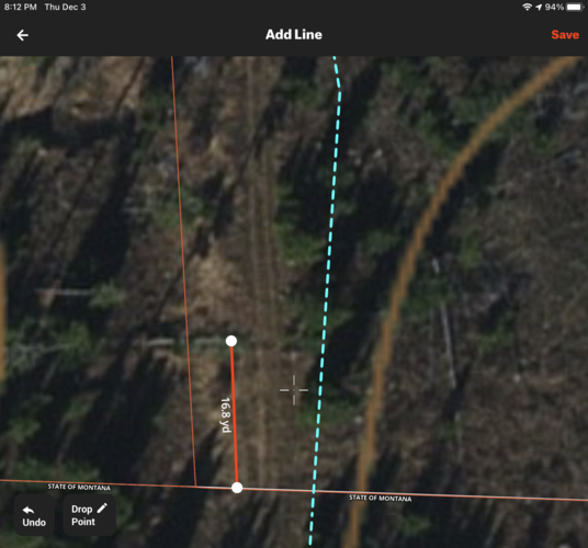
Property next to mine in MT just sold. It borders state land and there’s a fence between that property and the state land as well as recent survey stakes confirming accuracy of the fence. You can see below OnX is off by about 50’. The south end of the state land boundary also seems to be off about the same amount based on fences.


Land Ownership Maps & Parcel Viewer: See Property Lines With onX Hunt
Learn how the onX Hunt App’s land ownership maps and parcel viewer help you explore property lines, identify landowners, and navigate your hunt with confidence.
Product is very valuable to me for work and play. If folks aren't happy with it, they should save the $30/year.
Howdy fellas, So a question for you. How much would you be willing to stake on how accurate OnX really is? The reason I ask is this. This fall I was hunting in Colorado. As you can see in the attached photo. It clearly shows that part of the "owners" ag land is marked as BLM. Then as you can see my tracks is clearly way into the BLM BUT there was a fence and gate right there that says private no hunting or trespassing. Violators will be prosecuted to the fullest extent of the law. This section of private had hundreds of deer on it. When I talked to the fish and game officer he said this ranch has a very strict no recovery policy. So If you did happen to shoot a deer on public and it did die in the yellow part of the ag land would you possibly risk your gun, truck, fines, loss of hunting privilege's to recover it?
I would probably risk it. If the man gets you, the man gets you. I doubt they’d be able to take all my stuff on a first offense, especially if I didn’t shoot the animal on their land.
Irrelevant
Well-known member
If you stand on the fence does it show you on the property line or on the fence location on the aerial?Property next to mine in MT just sold. It borders state land and there’s a fence between that property and the state land as well as recent survey stakes confirming accuracy of the fence. You can see below OnX is off by about 50’. The south end of the state land boundary also seems to be off about the same amount based on fences.
View attachment 164914
mxracer317
Well-known member
- Joined
- Nov 20, 2020
- Messages
- 1,321
Why is that?This is a unit it took me 12 years to draw and I have no interest in going back. I normally would.
RobG
Well-known member
Is this something different than the default OnX?
Land Ownership Maps & Parcel Viewer: See Property Lines With onX Hunt
Learn how the onX Hunt App’s land ownership maps and parcel viewer help you explore property lines, identify landowners, and navigate your hunt with confidence.www.onxmaps.com
Product is very valuable to me for work and play. If folks aren't happy with it, they should save the $30/year.
Wildabeest
Well-known member
Haven’t checked that exact spot, but I’ve had the tracker on further to east of that same boundary line where the trail runs just on the state side of the fence line. OnX shows me being 50’ onto private at that point. I know the private land owner there, and he says the fence line is the property line. So I think the property lines are what’s off on the map, not something related to my GPS.If you stand on the fence does it show you on the property line or on the fence location on the aerial?
That’s interesting because it looks like 3 of the 4 lines are correct. So if it is incorrect it should be showing more acres than you own in ONX. It is definitely possible it is correct and the lot lines were just marked wrong when the houses were built. If i were you I would figure out what exactly I’m paying taxes on. In my experience in KS and Iowa, those lines are almost always correct with what is deeded and many physical property boundaries are wrong.
grandejuan
Active member
I know of a case here in AZ that the "developer" eyeballed the lot lines. My friend built on "his" property only to find out with a real survey that his garage was on the neighbors land. The cheapskate "title" company had to be brought to court to get everything cleared up. A real mess for sure and as soon as the word got out the developer skipped town for parts unknown.GJ
Similar threads
- Replies
- 5
- Views
- 550
- Replies
- 24
- Views
- 2K
Latest posts
-
-
AZ Elk anyone want to come along?
- Latest: Frequently Banned Troll
-
-
-


