Caribou Gear Tarp

History Found In the Field

The people’s who made these circles are not known. Modern Native Americans say they have no recollections or history of who made the stone circles(presumably to hold down a lodge). Natives used wooden pegs to hold down their lodges.
If anyone can enlighten further please do so.
I was always told such circles where "teepee circles", but Eric's comments gave me pause. I did spend probably too much time this evening on Google Scholar (just as I often do for my "day job" as a college engineering professor), and I found several research papers discussing the archaeology of teepee rings across the western US and Canada. Some supported Eric's statement above, but many also supported (including written historical observations) the use of stones as boundary weights, and some further speculations about things such as burial circles and maybe spiritual circles. Anyway, one good compilation reference of historical observations, although admittedly a bit dated, is T.F. Kehoe (1960) STONE TIPI RINGS IN NORTH-CENTRAL MONTANA AND THE ADJACENT PORTION OF ALBERTA, CANADA: THEIR HISTORICAL, ETHNOLOGICAL, AND ARCHEOLOGICAL ASPECTS.

I'll be up in that portion of Big Sky country this summer, so maybe I'll swing back by and take a little more careful look.
 
I'll be up in that portion of Big Sky country this summer, so maybe I'll swing back by and take a little more careful look.
If you explore Yellowstone, take the Escape Creek Trail just south of Gardiner but in YNP. As you crest the first hill above the bridge on the creek, take a left to the north and you will see the teepee ring. Then look NE toward the river and you will see a linear berm. Hike over to see a US Cavalry shooting range.

US Cavalry shooting range, circa 1886.
P1010373-001.JPG

Sixth graders from Gallatin Gateway School searching for expended bullets on shooting range berm, only to be told to leave them for others to find.
P1010376-001.JPG
 
These frying pans are from a well known logging camp in Idaho north of Freezeout Ridge. There are donkey engines and old flumes in there as well. It amazes me how much physical work was done by these miners and loggers in the last century. USFS has placed a historical marker at the site. Photos show these draws as nothing but stumps then. I do not know if this area was skipped over by the 1910 Big Burn. 100 years later it is so thick it is a pucker hole to go any farther up the creek. P9174280.JPGP9174281.JPGP9174284.JPGP9174277.JPG
 
Last edited:
On a 2021 road trip from Idaho to Arizona, we cut through the desert from Caliente, NV to Mesquite, NV. This is Bundy country. I do not know the story of the pioneer cabins, but the big arrow is one of the old 40' long Air Mail navigation arrows from about WWI time frame. They are all over the US and there is a sort of geo-caching culture to find them. The some of them later had the square foundations poured at the base of the arrow to support a light tower and power plant.

IMG_2021.JPGIMG_2014.JPG
 
I was always told such circles where "teepee circles", but Eric's comments gave me pause. I did spend probably too much time this evening on Google Scholar (just as I often do for my "day job" as a college engineering professor), and I found several research papers discussing the archaeology of teepee rings across the western US and Canada. Some supported Eric's statement above, but many also supported (including written historical observations) the use of stones as boundary weights, and some further speculations about things such as burial circles and maybe spiritual circles. Anyway, one good compilation reference of historical observations, although admittedly a bit dated, is T.F. Kehoe (1960) STONE TIPI RINGS IN NORTH-CENTRAL MONTANA AND THE ADJACENT PORTION OF ALBERTA, CANADA: THEIR HISTORICAL, ETHNOLOGICAL, AND ARCHEOLOGICAL ASPECTS.

I'll be up in that portion of Big Sky country this summer, so maybe I'll swing back by and take a little more careful look.
If you’re in the neighborhood call, I can point you to a lot of interesting local ancient, and not so ancient history, pishkuns, rock driving lines, stone rings, ect..
 
I found an Indian Matate' on a mountain years ago,
Javelina hunting,
and left it for others to enjoy.
It is gone now...
We did tag out-2 for 2! (archery) 💥
 
This is pretty cool and I got to keep it. It died only about 50 miles from where it was tagged.
 

Attachments

  • 9BE579DA-9C72-4F3E-B410-3D8E4E34259B.jpeg
    9BE579DA-9C72-4F3E-B410-3D8E4E34259B.jpeg
    1.7 MB · Views: 98
  • 39A1C7D6-CFCD-48E6-866D-5727585B86AD.jpeg
    39A1C7D6-CFCD-48E6-866D-5727585B86AD.jpeg
    2.9 MB · Views: 98
  • 706D5199-91A6-4DBB-82CB-B40DAFCB361F.jpeg
    706D5199-91A6-4DBB-82CB-B40DAFCB361F.jpeg
    446.5 KB · Views: 99
If you explore Yellowstone, take the Escape Creek Trail just south of Gardiner but in YNP. As you crest the first hill above the bridge on the creek, take a left to the north and you will see the teepee ring. Then look NE toward the river and you will see a linear berm. Hike over to see a US Cavalry shooting range.

US Cavalry shooting range, circa 1886.
View attachment 216156

Sixth graders from Gallatin Gateway School searching for expended bullets on shooting range berm, only to be told to leave them for others to find.
View attachment 216158
Glad it’s still there! Hasn’t changed since I was a kid. Quite a few teepee rings in the valley too back then. Hope they are still there.
 
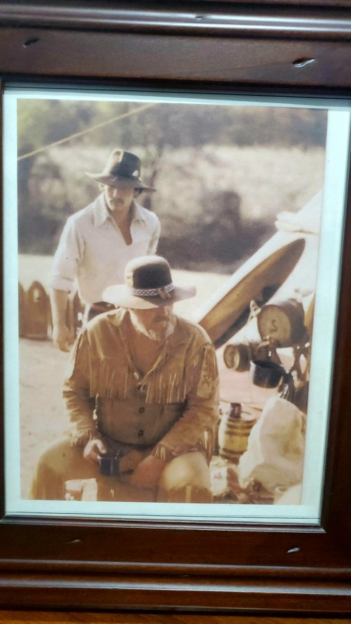
Very cool brother. Imagine touching them and being vaulted back in in time....to see their faces, hear their voices, follow in their footsteps. My dad and I were buckskinners and traveled around the country for years and I often thought I had been born 150 yrs too late....
 

Attachments

  • processed-45e58b17-f96e-49ec-b4f8-1d4868c6806d_nphagWia_remastered.jpg
    processed-45e58b17-f96e-49ec-b4f8-1d4868c6806d_nphagWia_remastered.jpg
    1.3 MB · Views: 33
I've come up with some interesting things at my family's ranch down in central Texas. One of the really cool ones I found was an old foot hold trap. Talking to family, no one knows of anyone who had trapped the land since at least the 1930s. The land has been in the family since the late 1890s, so it's not likely that we have had a lot of people on the land trapping. Immigrant crop sharing families from Mexico used the land in the 1930s and worked the land for the family. We have found old areas in the hill sides that were used as dugouts and lean-to shelters. Lots of pottery pieces as well. I will try and get some pictures of them if I can find them in the garage.
 
I have seen a few posts not just here of people moving grave markers, way points and I had corner markers on my gold claims removed. None of that is cool or funny at all to put it bluntly. I really hope people are just joking and not disturbing real markers as they are there for a reason and should never be moved except by the person who put them there.
 

Latest posts

Forum statistics

Threads
111,103
Messages
1,947,129
Members
35,028
Latest member
Sea Rover
Back
Top