MTNTOUGH - Use promo code RANDY for 30 days free

Google Earth Overlays

Bambistew

Well-known member
Joined
Dec 10, 2002
Messages
7,596
Location
Chugiak, AK
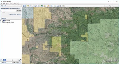
I'm always looking for another layer to add to Google Earth. Found this one (wasn't hard I admit) but thought I would share. Unfortunately I can't get Alaska to work for some reason, but other states in the west worked fine.

http://apeoid.com/kmz-kml-padus/
 
I like it...but I would like it better if it was see-through.Saves a click,you know what i mean?;)
 
I like it...but I would like it better if it was see-through.Saves a click,you know what i mean?;)

Most definitely. 50-75% transparency and the correct colors. :D Still, not bad. If I can figure out how to export a QGIS file to a KMZ-KML, I would darn near have what we need!
 
You can create a sub-folder, move the shape files into the folder and change the properties. For example, create a Forest Service folder, move all the FS shapes, and then go to properties,and change the transparency to 50% and color green.

I don't use GIS programs enough to know how to get the info out of it, but I know its possible to export a KML/KMZ files from Arc GIS.
 
I spent a few lunch hours at work compiling data from the State of Montana and other random sites that looked legit and then a couple weeks after color coding the data. Had the landowner info, color coding like the BLM maps, and had management areas and other little things in it like aerial photos of each individual county. Of course I was using QGIS since it was free and it might not have had the functionality like I wanted. Have not really played with ArcGIS. Its amazing what info is free and available to the public if you know how to use it and want to spend hours playing and researching.
 
I don't use GIS programs enough to know how to get the info out of it, but I know its possible to export a KML/KMZ files from Arc GIS.

You can do it within Google Earth Pro, which is now free. Shapefiles open directly in to pro, then you can right click, save as, and export as .kmz. Or if you're just using it for yourself, keep it as a shapefile.
 
Last edited:
I like it...but I would like it better if it was see-through.Saves a click,you know what i mean?;)

Click on "Adjust Opacity," which is next to the magnifying glass on the left side. Move slider to desired transparency.

It appears the data for MT is not all that current.
 
It appears the data for MT is not all that current.

WT, I agreed. Do you know how to turn off some layers? I noticed the prairie dog ACEC is on there. It no longer exists and covers up some of the other layers.
 
I don't know about map services for other states, but in Montana we have a plethora of GIS info.

Once you have followed Randy11 advice and gotten Google Earth Pro, go here. http://gisservice.mt.gov/arcgis/rest/services. Click through the directories until you get to the one you want at the mapserver level. At the top you'll have a choice of the API you want to use to view the data. Choose Google Earth or save the KMZ connection file and drag it into your Pro table of contents.

mapservice.jpg

Keep in mind, some of this data is probably scale dependent. So you may not see it till you are zoomed into a certain level. I haven't fiddled too much with map services and Google Earth, but I am sure other states have similar services. This data isn't a static flat file, but is being served to your google earth through the wire, and is therefore probably the most up-to-date version of the data publicly available.

googlehydrography.jpg
 
Last edited:
I spent a few lunch hours at work compiling data from the State of Montana and other random sites that looked legit and then a couple weeks after color coding the data. Had the landowner info, color coding like the BLM maps, and had management areas and other little things in it like aerial photos of each individual county. Of course I was using QGIS since it was free and it might not have had the functionality like I wanted. Have not really played with ArcGIS. Its amazing what info is free and available to the public if you know how to use it and want to spend hours playing and researching.

You should be able to easily save your shapefiles to KMZ in QGIS. My install is too old to open right now with my recently updated OS, but in QGIS 2.4 you could save any shapefile directly to KMZ. You'll have to play around with it, but its one of the choices in the dropdown menu of what type file you want to save as.

What I couldn't do, was get a high resolution geo-enabled PDF of the entire mapspace exported to use on my phone app. Its a one-clicker in ArcGIS.
 
WT, I agreed. Do you know how to turn off some layers? I noticed the prairie dog ACEC is on there. It no longer exists and covers up some of the other layers.

Expand the Montana layer as shown in the first pic below. Then click on the polygon you want to turn off, also shown in the first pic. That'll highlight it in the Montana layer. Uncheck that particular highlighted polygon.

Screenshot%205.png


Screenshot%206.png


P.S. PM me your email address and I'll send you something that may be helpful. :D
 
Expand the Montana layer as shown in the first pic below. Then click on the polygon you want to turn off, also shown in the first pic. That'll highlight it in the Montana layer. Uncheck that particular highlighted polygon.

Sweet. Apparenly I didn't "double click" enough times the first time I tried that.:D

PM sent.
 
You should be able to easily save your shapefiles to KMZ in QGIS.

If I remember right I think I got something to work but it was not a clean KML file. It looked more like a JPG overlay where colors looked right, but you could not click on individual parcels and get info or anything like that. Ill have to see if I can find my files and try it again just to be sure. Its been a year or so since I have played much with it. Either way, finding out Google Earth Pro is now free made my day so I had to play with it over lunch.
 
GeoCommunicator dot gov website, SMA, arcgis server, open or save for GE
 

Attachments

  • Clipboard01.jpg
    Clipboard01.jpg
    47.7 KB · Views: 524
Last edited:
The online mapping programs are truly a wealth of information, especially with all the GIS layers now available. I use a non-online ArcGIS Program for my day job, and I have recently started compiling data layers to generate my own personal maps for states across the country. I've got so much information for Colorado, that my map becomes totally incomprehensible with all the layers on. I find its almost as much fun trying to figure out the best places to hunt, as the actual hunt itself!!
 
Back
Top