goHUNT Mobile Maps comments sought in this thread

Just wanted to check back in after being insanely busy with work and daddy duty.

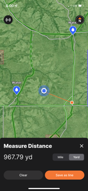
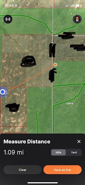
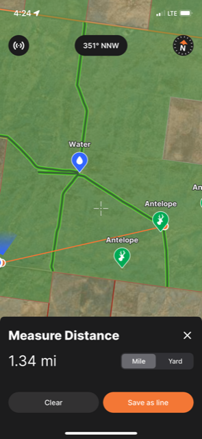
Went out on a very quick hike yesterday and my tracking is now working correctly and letting me save it. Not sure what the original issue was bud glad it’s gone. I ran the OnX track at the same time and while it ran and saved my distance it showed me being in Colorado the whole time…..I wasn’t even close. Lol

The real interesting thing was the differences in distance and elevation the two systems recorded. Not sure which is more accurate and how much it really matters, but here are the screen shots.
Interesting finals on those tracks. I will pass this along to the team to check out. Thank you!
 
Was using the app this weekend and it wouldn't seem to track on the GPS while the app was up and running. If I closed the app completely and opened it back up it had me pretty much where I thought I was. If I left the app open and moved 100 yards or 1/2 a mile the little blue dot just stayed in the same place.

Is there something I have set wrong? I just assumed the little blue dot would move when I moved?

Thanks, Nathan
Nathan,

Thanks for writing in with this. To me, it seems like you may be on an older build. The first thing I would suggest is to uninstall the app and then reinstall it. Number one, if there is an update available for your version this will pull that up, and two, it will fetch a fresh login which can clear up a lot of issues too.

Please let me know, thank you!
 
Has anyone else had issues with the tracking feature working, but being wildly inaccurate? Mine is showing me going places I never went when I have the tracker turned on and the track doesn't save as the route I actually took, but consists of lots of straight lines with corners cut, etc. Could be that I'm not using downloaded maps in airplane mode? But I'm operating in an area with ample cell coverage so it shouldn't be necessary and the app has no problem getting a fix on my location.
 
Not sure if it has been said further upstream, but it would be great if you could download "offline" maps for an entire unit instead of having to puzzle piece 3 or 4 or 8 together to cover your entire unit. For example, I want to pick Unit 22 and I can select to download the entire unit map in either high detail or low detail.
 
Has anyone else had issues with the tracking feature working, but being wildly inaccurate? Mine is showing me going places I never went when I have the tracker turned on and the track doesn't save as the route I actually took, but consists of lots of straight lines with corners cut, etc. Could be that I'm not using downloaded maps in airplane mode? But I'm operating in an area with ample cell coverage so it shouldn't be necessary and the app has no problem getting a fix on my location.
Apologies for the late reply!

We did have some location issues on some previous builds. I would first ask you to head to the app store to check to see if your app is up to date.

As of 8/30 the current iOS build is 745 and Android is 5270. Thank you!
 
Not sure if it has been said further upstream, but it would be great if you could download "offline" maps for an entire unit instead of having to puzzle piece 3 or 4 or 8 together to cover your entire unit. For example, I want to pick Unit 22 and I can select to download the entire unit map in either high detail or low detail.
We are working on the ability to make map downloads go to megasize!

Current maps are held to about 2.5-3gb in space which will cover an enormous area. I still like to keep my downloads to around 1-1.5gb for performance, though.

Thank you!
 
We are working on the ability to make map downloads go to megasize!

Current maps are held to about 2.5-3gb in space which will cover an enormous area. I still like to keep my downloads to around 1-1.5gb for performance, though.

Thank you!
It's not that I necessarily need a "Mega" size. Moreso the ability to only download the area I need relevant to a specific zone. I don't care if I get 100 square miles if it also includes sections of 4 other zones that I'm not going into. Does that make sense?
 
Apologies for the late reply!

We did have some location issues on some previous builds. I would first ask you to head to the app store to check to see if your app is up to date.

As of 8/30 the current iOS build is 745 and Android is 5270. Thank you!
Based on some of the other feedback in this thread, I deleted and reinstalled the app. So that's the build I'm showing, but I haven't been out to test the tracking feature since I did it. Not sure if it was updated to that build yet when I was having the problems. Hopefully will get a hike in before the end of the week to test it out. Thanks!
 
Doing some final escouting and looking at the terrain analysis; it would be cool if we could color code the different slope angles.
I’m sure others smarter than me have already asked for that though.
 
Hi all,

Wanted to share some of my experiences using GoHunt Maps on a recent pronghorn trip. It surely has all the bells and whistles, however I found reliability to be sorely lacking.
  1. While the app has been touted as removing the need to download a patchwork of maps in order to hunt an area, I did not find this to be the case. I ultimately had to download 5 separate squares to cover my hunt area.
  2. I had a very difficult time getting my offline maps to download even when connected to WiFi. One or two squares would download, then the remainder would stick on Pending. Deleting and reinstalling the app several times eventually got me around this issue.
  3. I spotted a small herd of pronghorn at about 800 yards on the first afternoon of my hunt. I tried to call up GoHunt Maps to mark the herd and plan my stalk but got the blank screen attached below. Not very useful.
  4. The location services seemed to be okay when I was driving but tended to be way off when I was sitting still or on a stalk. Sometimes it would be off a few hundred yards, sometimes a mile or more. See three images below. Oddly, OnX was dead-on my location each time.
I was fairly disappointed that the app couldn't get the basics right. I'm optimistic that the next update will resolve these issues. The silver lining, though, is that Nate from GoHunt was incredible and walked me through the download issue. Dude even called me *from* a mule deer hunt to help troubleshoot. Whatever they're paying him, it isn't enough.
 

Attachments

  • IMG_2587.PNG
    IMG_2587.PNG
    219.3 KB · Views: 5
  • IMG_2592.PNG
    IMG_2592.PNG
    866.7 KB · Views: 5
  • IMG_2593.jpg
    IMG_2593.jpg
    52 KB · Views: 5
  • IMG_2602.PNG
    IMG_2602.PNG
    810.7 KB · Views: 5
Is there a way to show whether STLs in Colorado are open to public or not? Onx tells you but not finding that feature in GoHunt. At least not on desktop, haven't tried the app yet.
 
Is there a way to show whether STLs in Colorado are open to public or not? Onx tells you but not finding that feature in GoHunt. At least not on desktop, haven't tried the app yet.
I just crosschecked GoHunt against the Colorado State Recreation Lands brochure (https://cpw.state.co.us/Documents/RulesRegs/Brochure/lands.pdf). Not sure whether it was coincidence or if GoHunt selected only the STLs open to public hunting, but all of the ones I checked were accessible to the public.
 
Just wanted to update. Had some major issues over summer but ever since updating the app and continuing to do so since it’s been perfect.

Have a question though that can hopefully be answered. Why can’t you view elevation gained and lost when tracking or going back and looking at previous tracks?? And is it in the works? I think it would be really helpful
 
Ollin Magnetic Digiscoping Systems

Forum statistics

Threads
111,062
Messages
1,945,482
Members
35,001
Latest member
samcarp
Back
Top