Finding deer habitat to scout and hunt

Outbound

Member
Joined
Jun 11, 2020
Messages
32
As a newbie hunter, I'm beginning my scouting for this season now. I'm doing my best to avoid the farm fields and private land the majority of the people in my region of northern Alberta tend to hunt. I want to get off the beaten path and put some miles on my boots. Right now, I'm using a combination of Backroads Mapbooks and Google Earth to narrow down areas to start actively scouting.

My question is when looking at terrain and satellite images, what features do you look for when it comes to deer habitat? Valleys, rivers, clear cuts, cut lines, meadows?

For anyone interested in checking out my region, or any Albertans reading this, I'm looking to hunt between Grande Prairie and Grande Cache to start and maybe go as far south as Hinton.
 
I can only speak on whitetails at this point, but any sort of edge habitat is a good place to start. This will be where one type of vegetation and another meet. This occurs in areas like the edges of logging activity and undisturbed land. Edges of burns. Where cropland and other types of land meet. Where river or steam bottoms transition to upland areas is another good spot. Pretty much any area where habitat changes.

Sometimes the best edge spots are very subtle. It could just be an area where two differnet types of forest meet. Here an example would be where willow oak and water oak stands merge into overcup oaks and nuttall oaks or something similar.

Great, thanks for the info. I do have a couple places in mind that meet that description. I should also say that whitetail will be my primary quarry.

How far does vehicle traffic usually push deer back into the bush? Road hunting is modus operandi around here, so I'm certain that come fall the deer will hang back farther into the bush. My thought is to search for areas out of sight of the road hunters and try and find the deer avoiding the traffic.
.

I have never dealt with road hunting really due to the fact that most of our public ground is too thickly vegetated to make it effective.

If most people stick close to the roads and trails like they do here you may not have to go that far. Just getting a half mile off of the road or ATV trail around here gets you past 90% of the other hunters. You will just have to evaluate the hunting pressure where you are.

I will say this though, sometimes there will be overlooked areas that hold whitetails very close to roads and trails. One of my most consistent spots it about a quarter mile from the parking area at an ATV trail. Everyone gets on there ATV and drives away from it.

Your best bet is going to be to start scouting with boots on the ground as soon as possible. Google earth and other maps are great but they are not a substitute for getting out there and learning the landscape first hand.
 
Your best bet is going to be to start scouting with boots on the ground as soon as possible. Google earth and other maps are great but they are not a substitute for getting out there and learning the landscape first hand.

I agree totally. I'm hoping to put some miles on next week and check out a few areas.
 
My thought is to search for areas out of sight of the road hunters and try and find the deer avoiding the traffic.
I think this is a great idea. Going through my memory, I have often found deer relatively close to the road but not able to be seen. It doesn't;t take much of a change in terrain for an unseen pocket to be created. I don't think you should avoid farm fields necessarily. After all, there is a reason most people hunt those fields. Either way, it seems like you have a good plan and some good suggestions here. good luck.
 
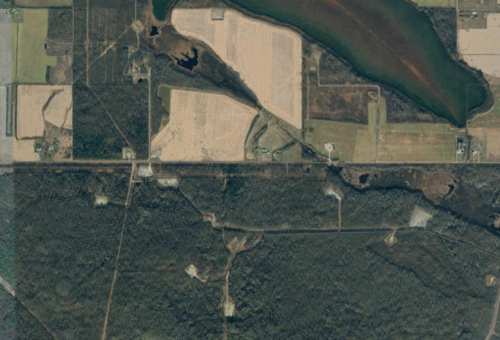
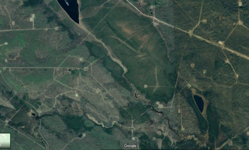
Here's a couple spots I've located and plan to check out. I'm going to get out and walk these in a few weeks when I get back home from a training course. Anybody have any intial impressions from sat imagery? Am I on the right track for deer habitat?

First up is a spot that has private land, farmer's fields, north of a road. South of the road is public land with what looks like decent cover, some water sources and a couple cut lines. There are also a few oil leases.

Huntspot1.PNG

The second is further south and west of the first. It has a stream that flows into a lake, a bunch of cut lines and what looks like some larger cut blocks with a bit more open country.

Huntspot2.PNG
 
One spot I hunt for whitetails is less than 100 yards from where others are road hunting. It is a ravine lined with thick brush. You cannot see down into it from the road. Deer walk it all day long and don't give one hoot about the trucks driving by.
 
Back
Top