

Navigation
Install the app
How to install the app on iOS
Follow along with the video below to see how to install our site as a web app on your home screen.
Note: This feature may not be available in some browsers.
More options

You are using an out of date browser. It may not display this or other websites correctly.
You should upgrade or use an alternative browser.
You should upgrade or use an alternative browser.
Ask your onX Hunt questions here!
- Thread starter Big Fin
- Start date

Apologies if repeated question...did a quick search and didnt see it answered...
When using onx to provide driving directions to a waypoint, can I assume it defaults to roads open for public travel? (E.g. county roads, or open NFS roads, etc.) Not routing on BLM roads that might cross private or originate on private?
When using onx to provide driving directions to a waypoint, can I assume it defaults to roads open for public travel? (E.g. county roads, or open NFS roads, etc.) Not routing on BLM roads that might cross private or originate on private?
WapitiBob
Well-known member
How do I update the Wildfire coverage. I really need to see the MN fires, and they do not seem to be updating.
you go to inciweb
WapitiBob
Well-known member
Apologies if repeated question...did a quick search and didnt see it answered...
When using onx to provide driving directions to a waypoint, can I assume it defaults to roads open for public travel? (E.g. county roads, or open NFS roads, etc.) Not routing on BLM roads that might cross private or originate on private?
it will absolutely take you down a private road

Wanted to ask about this again. Has bulk editing of markups been added as feature to the desktop version yet? Example, 150 glassing waypoints imported from Google Earth that I'd like to select all at once and change the symbol to glassing instead of the standard OnX symbol.Unfortunately, we do not have the ability to do a bulk edit of markups at this time. I can definitely see how useful that feature could be, so I'll definitely mention out to our engineering teams.

Khunter
Well-known member
@Nawright Been using onx forever and do not know to what you are speaking. Opacity layer? What is it and what is it ‘doing’? I see perfectly clear satellite images with nothing covering them up.Does anyone know how to turn off the Opacity layer. I just want to see a regular satellite image or topo map without the friggin opacity.
post screenshot showing nthe offending ‘opacity’ and I bet you get help to resolve. Took you 8 years to finally make a post? Don’t wait another 8!
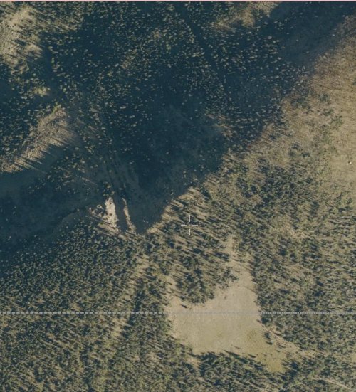
Last edited:
WapitiBob
Well-known member
There is no "opacity layer", you have an additional layer turned on.
nope
Wanted to ask about this again. Has bulk editing of markups been added as feature to the desktop version yet? Example, 150 glassing waypoints imported from Google Earth that I'd like to select all at once and change the symbol to glassing instead of the standard OnX symbol.
nope

BrentD
Well-known member
I disagree. Public areas are semi, opaque and difficult to see. It is annoying.There is no "opacity layer", you have an additional layer turned on.
nope
WapitiBob
Well-known member
I disagree. Public areas are semi, opaque and difficult to see. It is annoying.
Public land is a layer on top of the chosen basemap, and requires some opacity to be able to see that underlying basemap, there is no separate "opacity" layer in the context of the question raised. He has a layer turned on, it could be any layer, if he turns it off his opacity issue will go way and he will see only the basemap, as shown in Khunters photo.
BrentD
Well-known member
I realized that, but it still leaves you with the problem. Further, any polygon you draw out then becomes semi. Opaque as well. Obviously the interior of that polygon has something interesting, which is why you outlined it in the first place, and now you have trouble seeing it. It's a pain in the butt, and there might be better workarounds.Public land is a layer on top of the chosen basemap, and requires some opacity to be able to see that underlying basemap, there is no separate "opacity" layer in the context of the question raised. He has a layer turned on, turn it off and his opacity issue will go way and he will see only the basemap.
Obscuring the image of the layer of interest is a piss poor way of illustrating the area of interest, don't you think?


Bowmannate2000
Well-known member
Mine is working on Android phone.Is OnX maps down for anyone else today?
BrentD
Well-known member
Mine is working, android.Is OnX maps down for anyone else today?
So far, they have not changed Lake Ontario's name like they did the Gulf of Mexico. I am very disappointed in the latter.
BillDoe708
Active member
Any tips on getting my on x to work through android auto with offline maps?
WapitiBob
Well-known member
I realized that, but it still leaves you with the problem. Further, any polygon you draw out then becomes semi. Opaque as well. Obviously the interior of that polygon has something interesting, which is why you outlined it in the first place, and now you have trouble seeing it. It's a pain in the butt, and there might be better workarounds.
Obscuring the image of the layer of interest is a piss poor way of illustrating the area of interest, don't you think?
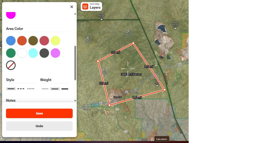
The first thing I do when drawing an area is to turn off the fill.
BrentD
Well-known member
Not sure how to do that, but i will figure it out,now that I know it can be done.The first thing I do when drawing an area is to turn off the fill.
kwyeewyk
Well-known member
Looks like onX Hunt hasn't been online since January, still shows as an active member but I can't @ tag them for some reason.
WapitiBob
Well-known member
Not sure how to do that, but i will figure it out,now that I know it can be done.
yep, easy
Rogerdoger
Active member
Don’t use polygon, use the line tool. This also won’t mess view when you hit the area.I realized that, but it still leaves you with the problem. Further, any polygon you draw out then becomes semi. Opaque as well. Obviously the interior of that polygon has something interesting, which is why you outlined it in the first place, and now you have trouble seeing it. It's a pain in the butt, and there might be better workarounds.
Obscuring the image of the layer of interest is a piss poor way of illustrating the area of interest, don't you think?
I then turn of government land layer, but I still have all boundaries marked. I get what you are saying, the way the opacity fades in and out with zoom drives me crazy.
Similar threads
- Replies
- 17
- Views
- 2K