Caribou Gear Tarp

USDA Forest Service seeks help to expand access to national forests and grassland areas

joelweb

Well-known member
Joined
Nov 20, 2012
Messages
362
Location
Big Sky Country
Now the Forest Service is seeking your input.

News Release

USDA Forest Service seeks help to expand access to national forests and grassland areas

Dingell Act mandates agency review of federal lands where access to agency land is inaccessible or limited to the public


Press Office

(202) 205-1134


WASHINGTON

February 12, 2020 -

The U.S. Department of Agriculture’s Forest Service is seeking public assistance to help identify national forest and grassland areas where the agency can provide greater access to hunting, fishing, and other recreational opportunities.
The agency today posted a draft list of about 90,000 acres of Forest Service land where hunters, anglers, and other recreationists are allowed but have limited or no legal access to the areas. The outreach is tied to agency efforts to implement the John D. Dingell, Jr., Conservation, Management, and Recreation Act of 2019 that mandates federal land management agencies work to evaluate how to expand access to public lands.
The Forest Service is seeking nominations that describe federal lands not on the list. The lands identified must be managed by the Forest Service, be a minimum of 640 contiguous acres, and be unreachable by foot, horseback, motorized vehicle or nonmotorized vehicle because there is no public access over non-Forest Service land, or the access is significantly restricted.
“National forests and grasslands play host to some 300 million hunters, anglers, and other recreationists each year,” said Forest Service Chief Vicki Christiansen. “The input we receive will go a long way toward helping the Forest Service provide even greater access and opportunity for the people we serve.”
The public nomination period to identify parcels for inclusion on the agency’s priority list will close on March 12, 2020. A final priority list will be published soon after and will be updated at least every two years until 2029.
To nominate a parcel of Forest Service land for consideration, email [email protected] or write to Lands and Realty Management, ATTN: Access Nominations, USDA Forest Service, 1400 Independence Ave. SW, Washington, DC 20250-1111. Nominations must include the location of the land or parcel, total acreage affected (if known), and a narrative describing the lack of access.
Background
The John D. Dingell Jr. Conservation, Management, and Recreation Act of 2019 is a broad-based law that sets provisions for various programs, projects, activities, and studies in the management and conservation of federally managed natural resources. The law includes steps agencies must take on how federal acres that are now essentially inaccessible may be opened to the public. The collective work of the Forest Service and interested citizens will help the agency decide how to reasonably provide access through such measures as easements, rights-of-way, or fee title from a willing landowner.
 
and here is the list they are starting with...

John D. Dingell, Jr. Conservation, Management, and Recreation Act

On March 12, 2019, President Trump signed S. 47 into law as Public Law 116-9, the John D. Dingell, Jr. Conservation, Management, and Recreation Act.

In accordance with SEC. 4105. IDENTIFYING OPPORTUNITIES FOR RECREATION, HUNTING, AND FISHING ON FEDERAL LAND; the USDA Forest Service is providing the following priority list and is seeking nominations that describe areas on agency lands where access is currently nonexistent or limited for hunting, fishing or other recreational opportunities.
The agency wants to hear from the public about those areas on national forests and grasslands that are not on the list. The lands nominated must be managed by the Forest Service, be a minimum of 640 acres, and unreachable by foot, horseback, motorized vehicle or non-motorized vehicle because of the presence of lands owned or managed by others.

Forest Service Priority List
REGIONNATIONAL FOREST - GRASSLANDRANGER DISTRICT - GRASSLANDTownship, Range, Section, Etc.
(Location of the parcel)
Acreage
(estimate)
Access
Needed
01Beaverhead-DeerlodgeButteT3N, R2W and T3N, R3W, multiple sec.8,900Private
01Custer GallatinBozemanT3N and T4N, R6E, multiple sec.1,920Private
01Custer GallatinYellowstoneT4N, R12E, multiple sec.1,600Private
01FlatheadGlacier ViewT30 and 31N, R 19 and 20 W, multiple sec.1,880Private
02Arapaho/RooseveltCanyon LakesT11N, R66W, Sec 26640Private
02Black HillsBearlodgeT52N, R65W, Secs 28-331,781Private
02Medicine Bow-RouttDouglas/Thunder BasinT37N, R68W, Secs 7-10, 13-15, 17-21, 23, 27, 28, 30, 326,880BLM, Private
02NebraskaFall RiverT3S, R10E, Sec 24 BHM640Private
02San JuanColumbineT35N, R6W, Sec 5, 6, 7, 8, 9 NMPM1,034Private
02San JuanPagosaT33N, R1E, Sec 34, 35, 36 NMPM920BLM, Private
03CibolaKiowa/Rita BlancaT20N, R25E, Secs 15, 17, 18, 19, 20, 213,840State, Private
03CibolaMount TaylorT11N, R15W, Sec 16640Private
03CibolaMountainairT10N, R5E, Secs. 21, 28, 29, 30, 31, 32, and 331,280Private
03PrescottChino ValleyT19N and T20N, R5W and R6W16,000Private
06MalheurBlue MountainT12S, R30E, Sec 30640Private
06Okanogan-WenatcheeSnoqualmieT24N, R9E, Sec 11640State, Private
06Okanogan-WenatcheeChelanT28N, R23E, Sec 17 and 20640BLM, Private
06Okanogan-WenatcheeNachesT14N, R15E, Sec 32640State, Private
08Daniel BooneCumberland83.41'47.431W 38.2'33.135N832Private
08Daniel BooneStearns71.22'78W 36.14'3.N640Private
08Daniel BooneRedbird83.30'30.247W 37.0'15.876N3,004Private
08George Washington & JeffersonEastern DivideCraig County, VA5,760Private
08George Washington & JeffersonJames RiverTract 14, DB Alleghany County2,462Private
08George Washington & JeffersonMount RogersGlade Mountain Area4,300Private
08George Washington & JeffersonWarm SpringsTract O-407 Bath County3,640Private
09Mark TwainPotosi/FredericktownT34N, R4E, Sec 22-27, 34, 352,738Private
09MonongahelaGauleyUS Tract 372, Turkey Mtn Area4,404Private
09MonongahelaGreenbrierUS Tracts 317, 361a, 361e, 562, 563, 638c, 6414,853Private
09MonongahelaMarlintonUS Tracts M51a, 3724,950Private
09MonongahelaPotomacUS Tracts 945 and 11171,335Private
09MonongahelaWhite SulphurUS Tract 1403N6,825Private
09ShawneeMississippi BluffsT8S, R4W, Sec 17, 19, 20; T8S, R5W, Sec 13, 24868Private

Disclaimer: The priority list above is non-inclusive of all Forest Service land that may have restricted or no public access, this is a draft list and work in progress.
The Forest Service is now accepting nominations for parcels that are not mentioned on the list above. Parcels are required to meet the following guidelines:
  • to which there is no public access or egress; or
  • to which public access or egress to the legal boundaries of the land is significantly restricted (as determined by the Secretary).
  • Minimum size -- any land identified shall consist of contiguous acreage of at least 640 acres.
  • Means of Public Access and Egress Included -- by motorized or non-motorized vehicles; and on foot or horseback.
To nominate a parcel of Forest Service land for consideration email [email protected] or write to Lands and Realty Management, ATTN: Access Nominations, USDA Forest Service, 1400 Independence Ave. SW, Washington, DC 20250-1111.
Nominations should include a name, contact information and brief description of the land being nominated.
 
This seems like a distraction The government knows what public land is inaccessible. Are they just going to build a new road right through the private land? I highly doubt it. The public comment period may be required, but nothing will come of this. Government (state and federal) has sided with private landowner property rights in the lawsuits I have seen around me recently. taking away wilderness study designations is another example. I feel like this is a magician’s attempt to get to focus on one hand while he winds back and kicks you in the balls.

Sorry, a little fired up today. 😀
 
Thanks @joelweb , I will be digging into the inaccessible lands I know of and nominating what I can.

TRCP did a report you shared a while back on inaccessible lands. It would be great if they would release that dataset in a web map or a publicly available GIS Dataset so folks could really look into it themselves instead of a small-scale PDF. Maybe they have?

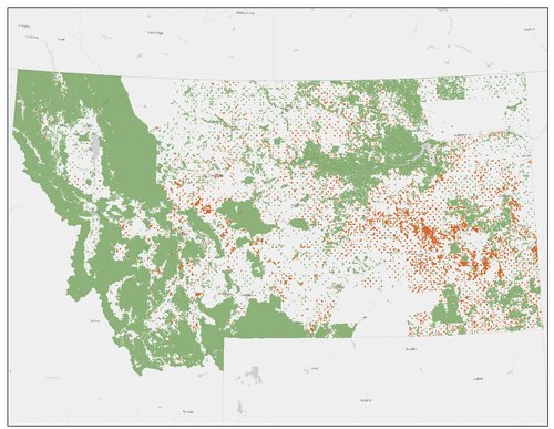
I made a map of inaccessible public lands years ago doing my own analysis, but unfortunately I no longer have the data.

Inaccessible.jpg


The minimum size guideline is unfortunate here. Think of what 40 acres can do in a state with Stream Access Law.

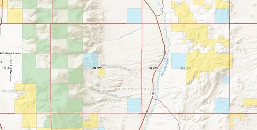
Any way, I looked into the list you put above for the B-D. 3N 2W does not have any Forest Service in it, but it does have BLM that is inaccessible. Does this have to be Forest Service land? Any way, when I was young and consequences meant less to me, I hiked all over the Bull Mountains checkerboard in 3N 3W with impunity, and it is amazing country that opening up would be a beautiful thing to do.

inacessible.JPG
 
Have hope, SAJ-99.

All of the federal land management agencies are going through this exercise as required by Sec. 4105 of the John D. Dingell, jr. Conservation, Management and Recreation Act.

The idea behind this measure is that it will help the land management agencies and land trusts prioritize access acquisition through the use of Land and Water Conservation Dollars. A minimum of $15 million is made available each year for this specific purpose. Moneys can be used to pay landowners for strategic acquisitions that open access to the public. This is all voluntary and no landowners will be forced to sell any land or easements across their land through this effort.

Below is the legislative text:

SEC. 4105. Identifying opportunities for recreation, hunting, and fishing on Federal land.

(a) Definitions.—In this section:

(1) SECRETARY.—The term “Secretary” means—

(A) the Secretary, with respect to land administered by—

(i) the Director of the National Park Service;

(ii) the Director of the United States Fish and Wildlife Service; and

(iii) the Director of the Bureau of Land Management; and

(B) the Secretary of Agriculture, with respect to land administered by the Chief of the Forest Service.

(2) STATE OR REGIONAL OFFICE.—The term “State or regional office” means—

(A) a State office of the Bureau of Land Management; or

(B) a regional office of—

(i) the National Park Service;

(ii) the United States Fish and Wildlife Service; or

(iii) the Forest Service.

(3) TRAVEL MANAGEMENT PLAN.—The term “travel management plan” means a plan for the management of travel—

(A) with respect to land under the jurisdiction of the National Park Service, on park roads and designated routes under section 4.10 of title 36, Code of Federal Regulations (or successor regulations);

(B) with respect to land under the jurisdiction of the United States Fish and Wildlife Service, on the land under a comprehensive conservation plan prepared under section 4(e) of the National Wildlife Refuge System Administration Act of 1966 (16 U.S.C. 668dd(e));

(C) with respect to land under the jurisdiction of the Forest Service, on National Forest System land under part 212 of title 36, Code of Federal Regulations (or successor regulations); and

(D) with respect to land under the jurisdiction of the Bureau of Land Management, under a resource management plan developed under the Federal Land Policy and Management Act of 1976 (43 U.S.C. 1701 et seq.).

(b) Priority lists required.—

(1) IN GENERAL.—Not later than 1 year after the date of enactment of this Act, and biennially thereafter during the 10-year period beginning on the date on which the first priority list is completed, the Secretary shall prepare a priority list, to be made publicly available on the website of the applicable Federal agency referred to in subsection (a)(1), which shall identify the location and acreage of land within the jurisdiction of each State or regional office on which the public is allowed, under Federal or State law, to hunt, fish, or use the land for other recreational purposes but—

(A) to which there is no public access or egress; or

(B) to which public access or egress to the legal boundaries of the land is significantly restricted (as determined by the Secretary).

(2) MINIMUM SIZE.—Any land identified under paragraph (1) shall consist of contiguous acreage of at least 640 acres.

(3) CONSIDERATIONS.—In preparing the priority list required under paragraph (1), the Secretary shall consider, with respect to the land—

(A) whether access is absent or merely restricted, including the extent of the restriction;

(B) the likelihood of resolving the absence of or restriction to public access;

(C) the potential for recreational use;

(D) any information received from the public or other stakeholders during the nomination process described in paragraph (5); and

(E) any other factor, as determined by the Secretary.

(4) ADJACENT LAND STATUS.—For each parcel of land on the priority list, the Secretary shall include in the priority list whether resolving the issue of public access or egress to the land would require acquisition of an easement, right-of-way, or fee title from—

(A) another Federal agency;

(B) a State, local, or Tribal government; or

(C) a private landowner.

(5) NOMINATION PROCESS.—In preparing a priority list under this section, the Secretary shall provide an opportunity for members of the public to nominate parcels for inclusion on the priority list.

(c) Access options.—With respect to land included on a priority list described in subsection (b), the Secretary shall develop and submit to the Committees on Appropriations and Energy and Natural Resources of the Senate and the Committees on Appropriations and Natural Resources of the House of Representatives a report on options for providing access that—

(1) identifies how public access and egress could reasonably be provided to the legal boundaries of the land in a manner that minimizes the impact on wildlife habitat and water quality;

(2) specifies the steps recommended to secure the access and egress, including acquiring an easement, right-of-way, or fee title from a willing owner of any land that abuts the land or the need to coordinate with State land management agencies or other Federal, State, or Tribal governments to allow for such access and egress; and

(3) is consistent with the travel management plan in effect on the land.

(d) Protection of personally identifying information.—In making the priority list and report prepared under subsections (b) and (c) available, the Secretary shall ensure that no personally identifying information is included, such as names or addresses of individuals or entities.

(e) Willing owners.—For purposes of providing any permits to, or entering into agreements with, a State, local, or Tribal government or private landowner with respect to the use of land under the jurisdiction of the government or landowner, the Secretary shall not take into account whether the State, local, or Tribal government or private landowner has granted or denied public access or egress to the land.

(f) Means of public access and egress included.—In considering public access and egress under subsections (b) and (c), the Secretary shall consider public access and egress to the legal boundaries of the land described in those subsections, including access and egress—

(1) by motorized or non-motorized vehicles; and

(2) on foot or horseback.

(g) Effect.—

(1) IN GENERAL.—This section shall have no effect on whether a particular recreational use shall be allowed on the land included in a priority list under this section.

(2) EFFECT OF ALLOWABLE USES ON AGENCY CONSIDERATION.—In preparing the priority list under subsection (b), the Secretary shall only consider recreational uses that are allowed on the land at the time that the priority list is prepared.
 
Glad you are weighing in, NamelessRange.

The BLM and US Fish and Wildlife Service have their own comment processes. They can be accessed here:
BLM: https://www.blm.gov/press-release/bureau-land-management-seeks-help-increasing-access-public-lands
USFWS: https://www.fws.gov/refuges/realty/Public-Access-Nominations.html

I hear ya on the importance of 40-acre parcels for stream access, and nothing about this process prevents future acquisitions like that, it just tries to focus limited resources on the largest parcels.
 
All of the federal land management agencies are going through this exercise as required by Sec. 4105 of the John D. Dingell, jr. Conservation, Management and Recreation Act.

The idea behind this measure is that it will help the land management agencies and land trusts prioritize access acquisition through the use of Land and Water Conservation Dollars. A minimum of $15 million is made available each year for this specific purpose. Moneys can be used to pay landowners for strategic acquisitions that open access to the public. This is all voluntary and no landowners will be forced to sell any land or easements across their land through this effort.
So it’s a survey monkey on which areas people can’t access are liked the best? If it has to be at least 640acres even $15m won’t buy much. BTW, did you see the latest budget submission? That program got practically eliminated. There is another thread on that.
I see Hope as an act of desperation. Right now we need to keep fighting.
 
I did an analysis last night and produced a list of over 1200 parcels in Montana, greater than 600 acres in size, that are inaccessible. Of course the analysis is rough and relies on publicly available datasets, so there will be some missing and some incorrectly attributed as inaccessible. I know the requirement of the legislative text says 640 acres, but that is an oversimplification and an oversight in my opinion, as many sections are slightly under 640 and many are over (the largest section in Montana is more than 1600 acres in size).

For anyone out there who would like to review it and dig deeper and nominate a parcel or 1200, the link to a spreadsheet containing those parcels is here:


On a side note, anyone with TRCP or OnX connections should get them to put this out there in a web map so folks don't have to look through it in tabular form. They already have the data. I could do it myself, but don't have the time right now.
 
Last edited:
So it’s a survey monkey on which areas people can’t access are liked the best? If it has to be at least 640acres even $15m won’t buy much. BTW, did you see the latest budget submission? That program got practically eliminated. There is another thread on that.
I see Hope as an act of desperation. Right now we need to keep fighting.
Something is always better than nothing by my figures.

Identifying which parcels are most desirable and then figuring out how agreeable neighboring landowners are to sell an easement for access and how much it will cost seems like progress to me.

This is way better than trying to wave a “magic wand” of eminent domain and the ensuing litigation and political fallout that would surely follow such a move. Also way better than continued handwringing and internet complaints over the status quo without any action.
 
In an era where working ranches and farms are constantly in search of new income getting a nice check for allowing access across your property might seem like a great deal.

Personally, I hope that most negotiated access is not accompanied by a lot of road construction into public lands. Perhaps up to the boundary but no further.
 
So it’s a survey monkey on which areas people can’t access are liked the best? If it has to be at least 640acres even $15m won’t buy much. BTW, did you see the latest budget submission? That program got practically eliminated. There is another thread on that.
I see Hope as an act of desperation. Right now we need to keep fighting.

The inaccessible parcels need to be 640 acres, but the acquisitions could be as little as a few acres to open access. $15 million a year for a couple decades will chip away at the problem. There are other dollars out there too.
 
Last edited:
I submitted on the only two I've ever found for the FS. One I found trying to deer hunt in HS and one trying to deer hunt since. Opposite ends of WA. I know there's a ton over on the westside that weyerhauser is locking people out of, but i figured the point was to just reference the ones each of us is most interested in.
 
I submitted on the only two I've ever found for the FS. One I found trying to deer hunt in HS and one trying to deer hunt since. Opposite ends of WA. I know there's a ton over on the westside that weyerhauser is locking people out of, but i figured the point was to just reference the ones each of us is most interested in.

I think it's smart to highlight the parcels that matter most.
 
I didn't even know we had BLM land in Texas. 12,000 acre ranch that has multiple roads leading into it, but they can't get a right of way. Got to find solutions. We actually have quite a bit of other should be public land in Texas, that like this one, are locked up because managers, or whoever, are not required to give us access to our own land. I BELIEVE its gonna change though, sloooowwwwwly!
 
Bumping this to the top...if you've ever complained about lack of access to public lands and are a user of National Forest or Grassland acres, I surely hope you weighed in before the March 12th deadline. If not, shame on you.
 
Back
Top