Researching roadless/atv trackless areas?

rideold

Well-known member
Joined
Oct 28, 2015
Messages
812
Location
Front Range of Colorado
Just back from a week of archery elk hunting in CO unit 421. No luck other than getting amongst some bugling on the first morning in an area that was too thick to get any kind of shot off in. Thought I had done my research and had some good spots marked on my maps. Biggest problem I ran into was getting away from the roads and ATV trails. I didn't realize from the maps I referenced that the entire unit as far as I can tell has an ATV trail every few miles. I had one heck of a time getting away from the motor vehicle traffic (not to mention the cattle!). What resources do folks use for finding areas that are away from the tracks/roads? I ran some basic GIS analysis using the spatial data I could cull from various sources as well as the forest service motor vehicle layer from TopRut but nothing seemed to point me to how many formal trails there were. Maybe I missed the boat when I mined for data but it seems like there should be something out there more comprehensive. I'm starting to think that the only way to get away from vehicles is either to hunt in wilderness areas or pick units with terrain that you can barely walk on let alone get an ATV on.

So, anyone have any research strategies they'd be willing to share? As an aside, I don't have anything against ATV's and I don't want to start an argument about their use or anything. They're just another vehicle. I just want to figure out how to cull areas from my maps that are regularly used by them since it seems the forest service motor vehicle mapping is either out of date or just doesn't include ATV only trails.

Thanks.
 
The best way to get away from ATV's is to hunt wilderness areas. It's always my plan, because i'll be honest. I hate ATV's and think they've ruined a lot of hunting areas. They just cater to the lazy.
 
Use CO hunting atlas on dow website. You can overlay every trail that is open on the mvum.
 
Call your local Ranger Station and get a copy of the MVUM. For me they are a key component of planning, but are often incomplete.


They just cater to the lazy.

And handicapped old dudes that want to keep hunting with their families....or are they just lazy too?
 

Attachments

  • download_20160927_125645.jpg
    download_20160927_125645.jpg
    33.1 KB · Views: 574
Hardly the majority. I could make a case to use an ATV, but I prefer to hobble along at my slow pace. If someone really needs it, that's fine, but those aren't the guys you see flying down closed roads.
 
The best way to get away from ATV's is to hunt wilderness areas. It's always my plan, because i'll be honest. I hate ATV's and think they've ruined a lot of hunting areas. They just cater to the lazy.

I definitely agree with the wilderness area as the best option for roadless/atv-less recreation though do not follow the same line on the anti-atv thoughts.
I have a UTV. I use it for hunting - legally.

Just like the firearm, it is the person... Just like the "sleds", it is the person... The item is not the issue - the person is the issue. A person lacking ethics / integrity will continue to make a mockery of our firearm, ATV, Sled use. Enforcement. Enforce the laws related to ATV/UTV/Rokon, Enduro use. Welcome US Forest Service LEO's when they inspect the campground, etc. Thank them for the work they do. If you have a problem about their lack of ability to enforce a certain area... it is all about the $$$. Tax dollars for the win. The Officer does his/her best... Doesn't need to hear your crap take on how they should do their job. If you have something worth investigating further... pass it on. I personally know and work with on occasions some of the FS LEO's and they do their best with the abilities afforded to them.
 
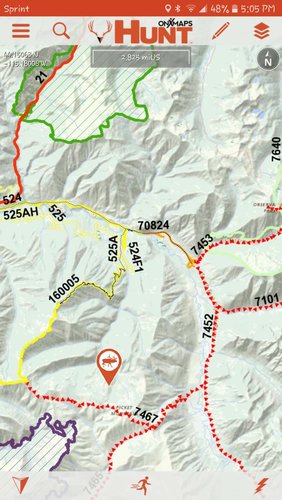
I used the ONx Hunt maps this year in Idaho a ton. I can see 2 track (ATV/UTV) roads, trails for horses and foot traffic and motorbike traffic etc. It came in handy when trying to find those places that people on 4 wheelers will not go. Ended up 3/4 of a mile from a 4 wheeler road (too narrow for a truck) where I shot my bull this year. It was a 1/4 mile straight up 500 vertical feet to hit the ridge line. Back side was a north facing slope that was just as steep as the side we hiked up. I can see everything that I need on the maps that they have. I wouldn't hunt without them now that I've used the app for the last two years.

We got into elk in one place two weeks prior on opening weekend. When we went back two weeks later and most of the places had quite a bit of 4 wheeler traffic and foot traffic and no elk. So we used the OnX maps to find places that the elk would go to get away from the easy foot traffic and 4 wheelers. We also moved around almost every day if we did not get into elk. We didn't waste time hitting the same spots unless we were in elk.

You can also see past burns etc. Lots of layers that you can turn on and off.

Image_1475017535618 (2).jpg
 
Last edited:
I used the ONx Hunt maps this year in Idaho a ton. I can see 2 track (ATV/UTV) roads, trails for horses and foot traffic and motorbike traffic etc. It came in handy when trying to find those places that people on 4 wheelers will not go. Ended up 3/4 of a mile from a 4 wheeler road (too narrow for a truck) where I shot my bull this year. It was a 1/4 mile straight up 500 vertical feet to hit the ridge line. Back side was a north facing slope that was just as steep as the side we hiked up. I can see everything that I need on the maps that they have. I wouldn't hunt without them now that I've used the app for the last two years.

We got into elk in one place two weeks prior on opening weekend. When we went back two weeks later and most of the places had quite a bit of 4 wheeler traffic and foot traffic and no elk. So we used the OnX maps to find places that the elk would go to get away from the easy foot traffic and 4 wheelers. We also moved around almost every day if we did not get into elk. We didn't waste time hitting the same spots unless we were in elk.

You can also see past burns etc. Lots of layers that you can turn on and off.

View attachment 62071

I'd delete the map...
 
I agree on the wilderness suggestion. Then look for steep and deep. Sucks getting there and hunting there but you won't see as many people. It doesn't bother the animals.
HD
 
Another vote for MVUM. They can be a PITA, but they have the information you are looking for. 421 occupies land in both White River and Grand Mesa National Forests, so you need to get several maps from the different offices/ web sites. I've used the maps to identify areas to go ride my ATVs with my family, and to ID areas to get away from the trails for hunting. As you found out, 421 is loaded with official ATV routes and usually has a ton of cattle during the earlier seasons.
 
I'd delete the map...
I can't delete it, I would if I could (no edit button anymore), but you also quoted it so it will still show.

If anyone has been to this place, it's not for the faint of heart. You best be in excellent shape and have a way to get an elk out other than on foot if you are that far in. It's a limited tag with approximately 2000 tags between rifle and archery, first come first serve. Very few go up the mountain, most putt around on their 4 wheeler on the roads down low.

This is not where I hunted, just one of the 8-10 places that I scouted, most of which burned in the Pioneer fire.
 
Last edited:
Coming from someone who has conducted off road surveys, usually half of the trails out there being created or used are not official or sanctioned. So usually not mapped. The Fed land managers don't have anywhere near the budget or personnel to keep track of new trails being created or enforcing closures. It usually only takes two or three folks to make something look like a road/trail in the arid portions of the west. I've seen magnesium sprayed on sandy spiderweb roads here in the Southwest to change the color and encourage folks to use the main trails.

As for a solution, spend time scouting in person and get a feel for it? I just got a free ATV from in laws that had needed some love after having someone blast past me as I was hiking 1.5 hours up to the top of a ATV track to scout. It was nicer to ride that to the end of the track then really hike in on my next scouting mission.
 
I just got a free ATV from in laws that had needed some love after having someone blast past me as I was hiking 1.5 hours up to the top of a ATV track to scout. It was nicer to ride that to the end of the track then really hike in on my next scouting mission.

I considered the use of an ATV each day as I bumped up Park Creek road in my old truck last week. I just want to get to the edge of the road travel areas and hike. I guess I don't care too much which vehicle I'm in. I'm not in a position to buy anything these days but maybe someday. Boots on the ground is still the best advice I seem to hear. Just have to figure out how to pick my summer camping trips with the family to coincide with the potential units I want to hunt!
 
Its not just a matter of getting away from them, it is a matter of getting out of ear shot from them. Units like this are the pits and demand that you do plenty of research before hunting there. I say this from experience. Been in the same shoes as you. Unfortunately, you cannot always tell until you are there. Anymore I avoid - at all costs - units where there is very little real estate between roads. If you are hunting someplace where you are never more than 2 miles from a road (especially on all sides) then I will never hunt there during bugle season. As soon as one lights up you can expect the masses to be there in 15-30 minutes.

You want to look for units with ATV restrictions during hunting season and very few roads on top of that.
 
And try a mapping program like OnXMaps for your phone or GPS. Not only does it show you ALL the roads, you can also use the imagery to see what shape they are in. But roads equate to walkers just as much as ATVs so my advice would be to avoid them all all costs and look for places with at least 5 miles between roads with a lot of up, down, and sideways between.
 
Use Promo Code Randy for 20% off OutdoorClass

Latest posts

Forum statistics

Threads
111,057
Messages
1,945,244
Members
34,993
Latest member
RAWMIA
Back
Top