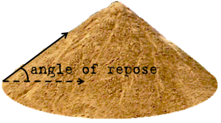
Most slopes over 35 degrees are likely to contain cliffs of some height of some kind of rock in order to overcome the maximum limits of angle of repose.
2020 will be my 4th year out west. I was always a map guy and spent a lot of time in the woods off trail, most of it in thick woods/alders/willow brush, etc. also peat bogs of MN which required some high stepping to get through. But dealing with the vertical while off trail is tough, and I think being able to read the topo and route finding is a big help.
I think I am better than most at navigating off trail, but last summer while scouting I accidentally came up through the purple spot on this map. 40-45+ degrees and it ended up being the worst 200 yards of hiking all year. It was thick trees and required crawling at times. So follow watch the map better than I was that day. 50 ft topo lines can hide a lot.
I mean, if you spot and stalk hunt in the mtns, you do often have to consider time and distance. You may not be thinking can I hike 2 miles in 30 min... but you may have to consider if you can cross a basin to get to a herd of elk before it gets dark.
I assume @Bambistew is constantly trying to glass up sheep and then planning long stalks that may take hours or days depending on terrain.
"I have never gave much thought into how far I could hike in a certain amount of time other then the hike in in the dark. "
This seems only to be relevant if you are hunting from the truck, hunting somewhere flat, still hunting, or hunting from a blind or stand.
Time management during a hunt takes some time to figure out, no reason to act like it's a stupid conversation, especially for a new hunter.
Ok thanks this makes sense. I did have a long distance stalk in mind when that post was made but I’m also reading Robby’s book that’s telling me not to walk very fast so who knows.
With apologies to many midwesterners and the accent that led them astray stalk verb
stalked; stalking; stalks
Definition of stalk intransitive verb
1: to pursue quarry or prey stealthily
stock verb
stocked; stocking; stocks
Definition of stock transitive verb
1: to procure or keep a stock ofour store stocks that brand
2: to provide with stock or a stock : SUPPLYstock a stream with trout
3: to fit to or with a stock
4: to graze (livestock) on land
5: to make (a domestic animal) pregnant
If you are off the trail and in bad deadfall, you do not measure your speed in miles per hour. you measure it in yards per hour. and hope you hit double digits! Well, maybe not quite that bad, but it sure can be slow going.
Yes. I call this my single most telling picture from my last elk hunt when someone asks how hard it was. This was in a section of woods we considered healthy compared to some others...
the funny part is, that picture does not do it justice. People who haven't been in a deadfall don't understand. I have walked over 100 yards in deadfall and never came close to touching the ground. I bet there are tons others that have done more. Ironically, I have never seen nor heard an elk in the truly nasty stuff. I have seen some sign, but never an elk.
You know my experience in the really dense blowdown is good sanctuary. Unless you find a way to do it right and stay out of wind undetected, they detect you long before you detect them. Most hunters I have been with make a ton of noise going through blowdown and that would be unnatural noise like hard heels clunking against a fallen log or a rifle or something.
90%+ of the sheds I find are in downfall like that. I think the elk like to browse on the moss' and lichen in the downed trees, and then knock their antlers off while scrounging around.
Im a Pa res and go to Idaho also and go to the same areas I never make a plan on how much ground Im going to cover in a day, once Im in my base area, due to the fact of how I feel on any given day and where the animals are one time elk were all around the area I call base camp even tho we dont set one up its our starting and meet up area. Other times we hiked quite a bit untill finding elk took days.
but when Im hunting its more about looking ,listening, than about how far I go
some times you cant find an animal and go to bed wake up and their they are close by
Train as hard as you can take it a bit easy first day or so get your mountain legs and lungs going and keep your mentally focused on hunting more than hiking any distance, but my camp is on my back so Im not thinking of getting back and when Im done for the day I find a place to set up for the night
Yes. I call this my single most telling picture from my last elk hunt when someone asks how hard it was. This was in a section of woods we considered healthy compared to some others...
I attempted to use the search function for this as I'm sure it's been asked and answered. I'm hunting Idaho for the first time this fall. The relief is something I've never had the chance to hike before. My question for those more experienced than myself is 1) What is a practical distance to cover in a day? Clearly this is a really wide open question as it doesn't factor in slope and ground cover but looking for general guidelines if possible. 2) What is a comfortable slope to try to stick to when route planning in onXmaps? It seems very easy to draw straight lines in onXmaps and then realize they are 28% ground slopes. Using switchbacks this can be reduced so I'm just wondering what people try to stick to when gaining elevation.
I am no elk expert having done my first hunt last September at the age of 53. I also have had many serious health issues. They include 3 knee surgeries and nerve damage in my bow arm from college football. I had a stent put in when I was 43 because of a Widowmaker Heart attack only 7 months after winning the Brazilian Jiu Jitsu Pan Ams. Then I fell through my stairs in a construction accident that caused 3 herniated discs in my neck and 3 in my lumbar. This caused me to be in PT for 7 Months in 2017. I couldn't lift a gallon of milk with my left hand for two months and it nearly brought me to tears to walk the dogs around the block for a year.
After PT I continued on my own doing those exercises along with Yoga and lots of planks. I added a kettlebell workout and then did backpack cardio with a 40-70 pound pack doing 2-4 miles a day before work. I would do each of these workouts 3-4x a week.
Fast forward to our trip to Colorado and when we got there we found our first pick spot was much steeper than realized. We had bugling bulls on the next ridge over from where we set up our base camp. We dropped 950 vertical feet in less than 1/3 mile and the same up the other side. We followed game trails down and had to side hill to the bottom. Between the steepness, the 4-6 foot tall fern that covered blowdowns it took about an hour to get to the bottom and on the opener with 91 degree temps and a 40 pound pack we carried in case of needing to bivy out it took almost 3 hours up that hill. I wear a fit bit and my peak heart rate coming back up to camp was 196 bpm! That's crazy high and the only other time my heart rate was that high was the day I had my heart attack. I had to stop at that point for about 15 minutes to drink some water and let my HR drop down to about 140 before continuing on to the top. We averaged 6-9 miles a day.
What I am illustrating is that if you get yourself into the best shape you can as well as have decent mental toughness you can push yourself beyond what you may think is possible.


")