Paper Map Advantages?

tomengineer

Active member
Joined
Jan 14, 2019
Messages
258
We all know onX is a pretty powerful tool for mapping routes and planning glassing spots and staying on public land etc. I'm just wondering if anyone finds paper maps to be helpful during planning, map scouting or in the field? I use the National Geographic trail maps here in the Adirondacks while hiking and they seem to be pretty good for planning purposes. They might show some more information than onX is able to. I'm also thinking they might be handy to have in the field to accompany my compass in case my navigation equipment fails. This is for the Sun Valley area of Idaho as well as the Sawtooth National Forest.
 
I always have paper maps with me and use them regularly. I like looking at the "big picture" of a unit from time to time rather than a 4 inch screen and worrying about battery life. But I'm old school. I use both onX and paper maps.
 
I think paper maps offer an advantage at home, draped over a desk, to allow someone to holistically see an area and the relationships of places within it in a way that is difficult on a screen. I think wllm1313 is right though, in the field they are unnecessary in the modern world. I suppose as a backup to a technological failure they might make sense, but in that scenario they aren't advantageous over electronic solutions, but are 2nd choice stop-gap.
 
I always carry a paper map, a custom map from Mytopo.com for every hunt area. I find it easier to do 'big picture' stuff on a big map, not my phone screen. Plus, the map batteries never die...
Ok awesome I didn't know about this site. I'll check it out.
 
You can write on them and make certain notes. You can also just open them up and get right into finding what you're looking for- no waiting for a GPS to load.

Also, when I was in the Army, there was always a heavy emphasis on land navigation with compasses and maps, despite having constant access to GPS. Land navigation is almost a lost art. Electronics will fail you at some point and you may need to know how to get from A to B.
 
I think paper maps offer an advantage at home, draped over a desk, to allow someone to holistically see an area and the relationships of places within it in a way that is difficult on a screen. I think wllm1313 is right though, in the field they are unnecessary in the modern world. I suppose as a backup to a technological failure they might make sense, but in that scenario they aren't advantageous over electronic solutions, but are 2nd choice stop-gap.

Exactly, paper maps help me construct a mental image of the landscape that allows me to quickly orient myself in the field, esp when going to completely new areas (which is what I like to do).

As far as getting lost... honestly for me, very little value. Perhaps if I decide to hunt some place past where I've e-scounted or downloaded data for so I have no idea what I'm walking into. I had this happen a few times with pronghorn and the gazetteer has been great. But if I'm in the woods on the side of a mountain, and my phone dies, and I've gotten myself thoroughly lost no map is going to help me. I've gotten lost 3-4 times, every time I had a paper map and compass, but they were basically worthless. Every single time I was in blow down at night, without any way to orient myself... knowing which direction north was didn't really help. Essentially I walked until I hit a feature I knew (road, river, peak, lake, etc) or I wait until the sun came up.
 
We all know onX is a pretty powerful tool for mapping routes and planning glassing spots and staying on public land etc. I'm just wondering if anyone finds paper maps to be helpful during planning, map scouting or in the field? I use the National Geographic trail maps here in the Adirondacks while hiking and they seem to be pretty good for planning purposes. They might show some more information than onX is able to. I'm also thinking they might be handy to have in the field to accompany my compass in case my navigation equipment fails. This is for the Sun Valley area of Idaho as well as the Sawtooth National Forest.

If you're in for several days (week or more) covering serious distance (point-to-point) then a paper map is useful. For example, I'd consider putting together a comprehensive map layer in physical form for any trip where I'm putting in required miles on a course to an extract.

But to spot-hunt, not necessary. Most of the time, no mapping software or physical maps are necessary unless you can't deal with not knowing option "A" and option "B".

Hmmmm my extraction point is 10 klicks north of point bravo... wtf is a klick....

 
Last edited:
Interesting range of comments here. Personally, I like a paper map and compass if for nothing else than a foolproof backup. With proper orienteering skills the two are indispensable. Sure, there are times that you are in a position that the map is as useless as the GPS with dead batteries but overall being able to look at the big picture and relate that to your position is invaluable to me.
 
Interesting range of comments here. Personally, I like a paper map and compass if for nothing else than a foolproof backup. With proper orienteering skills the two are indispensable. Sure, there are times that you are in a position that the map is as useless as the GPS with dead batteries but overall being able to look at the big picture and relate that to your position is invaluable to me.
I kind of agree with this. It weighs basically nothing and it's good to compare notes and game plans with other guys in the party or for emergency navigation.
 
From the perspective of a professional land surveyor, I offer this: I have better, more precise navigation equipment than most of you would ever consider owning, as it costs tens of thousands of dollars and can get readings to within less than a cm in the right conditions. It will fail, whether the batteries die, solar flares or a solar storm (which can last for hours, days, or a couple of weeks) kills the signal, or the military messes with the signal, which happened 3 weeks ago, rendering mine useless. A map will never let you down, as long as you can tell direction (which every outdoorsman needs to be able to do) and have some basic landmarks. So take it as a backup if you are out in the backcountry or any place you're not very familiar with. If you don't need it, like Ben said, you can always start an emergency fire with it! Lol
 
Love paper maps, although I'll admit I don't use them as much as I used to.

I bought an entire collection of USGS topo maps from a guy who used to own a map selling business that went belly up. I have an obscene amount of USGS quads, mostly from Wyoming but a bunch of other Western states as well. On top of that I got a ton of old BLM maps and other maps that the guy sold. I felt terrible about the price I paid for all those maps. The guy kept trying to sell them to me and I repeatedly declined saying that I couldn't possibly give him any amount of money for all those maps that wouldn't amount to highway robbery. I was a very, very broke recent college graduate at the time. I can't take them with me, he said, and I just want someone to have them that will appreciate them and use them or try to sell them. So I did.

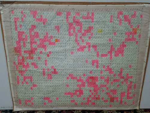
I've never sold any, although I probably should. There's no point owning 10 copies of a single 7.5 minute quadrangle in Wyoming. One of my wifes favorite pasttimes is giving me grief about having all those boxes of maps in the basement. I've only ever inventoried the Wyoming maps, which I organized alphabetically by as much as possible over the course of about 4 days. I have at least one of each of the quads I highlighted in pink in the state of Wyoming in the attached photo. I'd be willing to part with some of the duplicates I have if anyone's interested in Wyoming quads, shoot me a PM listing the quads your looking for. 20200305_174355.jpg
 
I like large topo maps for trip planning as I “see” the area differently/better than google earth pro on my laptop screen.

I then draw/color my own maps on copy paper, sometimes having several sheets if it’s a multi-day trip or I’m traveling over a large area. I’ve been doing this since I was 12, and it’s such an ingrained habit I doubt I’ll ever change it. Best purpose for me is drawing thermals, prevailing winds, alternative winds, and approach paths based on these and time of day.

I use OnX on my phone about 1/10 as much as my hand drawn maps. Very useful for waypoints and property lines.
 
This thread makes me happy. I've always loved maps. I've spent thousands of hours poring over maps, as I'm sure many of you have as well. I have an entire wall in my basement man cave made up of BLM maps taped together to give me a big picture land ownership and topography view of the places I hunt in SE Wyoming.

When I used to work as a tech in Pinedale, the GF had a HUGE statewide Wyoming map that had actual 3D relief and public land ownership that stuck out about 4 inches from the wall at its highest points. That's my favorite map of all time. In college I got to look over original copies of hand drawn maps from the Lewis and Clark expedition. That's right up there too.
 

Latest posts

Forum statistics

Threads
111,103
Messages
1,947,091
Members
35,027
Latest member
Debbry64
Back
Top