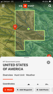
Anyone know what it means when on-X lists the owner of a parcel as “United States of America”. Not BLM, or USFS, or anything, just USA.
Is that public? The particular parcel I’m looking at is surrounded by other public land.
We have one of those outside of Laramie. I Googled the address listed and it comes up as the FWS in Denver.
Can you look up the address on a county GIS map and see the address listed for the owner?
That is how I came up with the Fish and Wildlife Service for the parcel here.
Man, its really hard to say what it is, or if it’s open just based on that. There are all kinds of little odd parcels that belong to one department or agency, but are managed by another through various agreements. Some are open, some are not. About the only way to know for sure is to call and ask someone.
Update for everyone, I just received an email back from the USFWS, who confirmed that parcel is part of the USFWS refuge that borders it to the East. And is open to the public. They were unsure of why On-X shows some small pieces like that as just "USA" rather than USFWS specifically.






 G@D@MN IT i'm never buying Concert tickets again....

