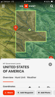
Anyone know what it means when on-X lists the owner of a parcel as “United States of America”. Not BLM, or USFS, or anything, just USA.
Is that public? The particular parcel I’m looking at is surrounded by other public land.
We have one of those outside of Laramie. I Googled the address listed and it comes up as the FWS in Denver.
Can you look up the address on a county GIS map and see the address listed for the owner?
That is how I came up with the Fish and Wildlife Service for the parcel here.