Accessing National forest beyond private

Magnum Sherpa

Well-known member
Joined
Oct 8, 2015
Messages
411
Location
Missoula, MT
I am trying to figure out how to legally access a section of National Forest in Beaverhead County, MT that lies beyond private land. The private is actually enrolled as type 1 Block Management, but I’m not interested in hunting that property, but rather traveling through it on the road that is listed as open for travel on the Block Management property rules. The road goes on through BLM, a state section, another small piece of the same Block Management, then on to National Forest. The road in question is a named road and appears on most maps, but when I pulled up a map of Beaverhead County roads it was not shown. At its terminus are several National Forest trails.
Does anyone know any other way to determine if the road is public or not? I would assume there is some way to legally access those trails on the National Forest, but I could be wrong. Also, would getting access to the Block Management allow me to travel on to the National Forest, camp and hunt on the Forest for several days, then travel back through the Block Management (not hunting) a few days later?
 
I am not sure what to make of your post but it sounds like the road is on BLM land. If so you should be able to travel it. If you have reservations I would get in touch with BLM, USFS or the local Forest Service or Game biologist. Do you have mapping software (ON-x, Basemap, Go Hunt) that gives you parcel names?
 
My guess without more info is that it may be a Forest Service road if it isn't county but appears to have public access and trailheads. I'm not sure I know of many FS trailheads that don't have legal access for the public.
 
I am not sure what to make of your post but it sounds like the road is on BLM land. If so you should be able to travel it. If you have reservations I would get in touch with BLM, USFS or the local Forest Service or Game biologist. Do you have mapping software (ON-x, Basemap, Go Hunt) that gives you parcel names?

I tried to make my explanation as simple as possible, but obviously wasn’t successful in that. The issue is the road crosses private land first before it gets to any of the public parcels. In Montana there are private lands open to public hunting with permission under a program called Block Management. The private section is enrolled in that program.

I have OnX and know who owns the private parcel. I was mainly unsure of whether Block Management can be used to access to other public parcels that lie beyond it.
 
My guess without more info is that it may be a Forest Service road if it isn't county but appears to have public access and trailheads. I'm not sure I know of many FS trailheads that don't have legal access for the public.

That was sort of what I was thinking. I‘ll probably need to either call or visit the local Forest Service office to be certain.
 
I tried to make my explanation as simple as possible, but obviously wasn’t successful in that. The issue is the road crosses private land first before it gets to any of the public parcels. In Montana there are private lands open to public hunting with permission under a program called Block Management. The private section is enrolled in that program.

I have OnX and know who owns the private parcel. I was mainly unsure of whether Block Management can be used to access to other public parcels that lie beyond it.
Of course you can. You said the Block Mgmt map shows it as an access road. I would just make sure you sign in to the Block Mgmt box.
 
Of course you can. You said the Block Mgmt map shows it as an access road. I would just make sure you sign in to the Block Mgmt box.

Do you think there would be an issue with camping on the National Forest for several days and then driving back out through the Block Management? If I did that my Block Management slip would be for the day I went in and not the day I was traveling back out.
 
I was looking at BMAs in MT and one that I looked at does not allow mule deer hunting, including no mule deer hunting on state trust land that is accessed through the BMA. It seems odd that they are able to add a restriction like that, but based on that it seems they could say you can't access certain public lands through the BMA. A thin invisible line.

Does the forest service website have any info on access to the trailhead? I guess I would start with calling them.
 
Do you think there would be an issue with camping on the National Forest for several days and then driving back out through the Block Management? If I did that my Block Management slip would be for the day I went in and not the day I was traveling back out.
No. Just sign another slip on the way out. The owner gets paid by the slip. The only caveat is to make sure the BMA map labels the road an access road and not a game retrieval road. Sounds like it is a pretty well-used access road from your description.
 
I am trying to figure out how to legally access a section of National Forest in Beaverhead County, MT that lies beyond private land. The private is actually enrolled as type 1 Block Management, but I’m not interested in hunting that property, but rather traveling through it on the road that is listed as open for travel on the Block Management property rules. The road goes on through BLM, a state section, another small piece of the same Block Management, then on to National Forest. The road in question is a named road and appears on most maps, but when I pulled up a map of Beaverhead County roads it was not shown. At its terminus are several National Forest trails.
Does anyone know any other way to determine if the road is public or not? I would assume there is some way to legally access those trails on the National Forest, but I could be wrong. Also, would getting access to the Block Management allow me to travel on to the National Forest, camp and hunt on the Forest for several days, then travel back through the Block Management (not hunting) a few days later?
Step one: look at county road map - looks like you've done that.

Step two: look at the national forest MVU map from their website. Side note here, if a road terminates at the national forest boundary, I've never came across an instance where it doesn't continue to the nearest county legal road. I have seen a county road map not show this forest road extension to the national first boundry but after quite a few times calling officials and experencing it in person, it's always a legal access road.

Step three: call the county office for verification of you're still unsure.
 
If the road is private...then just because it's a BMA that connects to public land does NOT mean you can use that road to access the public land just because it all connects. The boundary line is still protected and access must be granted by the private landowner.

Also, if the land is BMA and requires you to sign into use it (Type 1) then you must do so even if you are NOT hunting. This is your permission slip to be on the land.

Above is per FWP BMA Director.

To find out access on the road I would contact:
1. Private landowner.
2. Regional BMA Coordinator
3. County
4. USFS District
 
I would contact the land owner.
You cannot sign into BMA and use it to access adjacent public land unless the BMA explicitly allows it - if BMA rules for the property do not explicitly say you can acces the adjacent public section, you technically cannot. Some do allow access adjacent public, some don’t. BMA access is also for the explicit use of hunting - you cannot sign in for any other purpose other than for the intent to hunt. This means that if the road is not public, it is unlikely you can sign in then use the road to acces the public beyond.
Technically speaking, of course. You may or may not have issue regardless of the road status - some landowners in BMA don’t really care who is doing what so long as they have the signatures while others are absolute sticklers.
 
I was looking at BMAs in MT and one that I looked at does not allow mule deer hunting, including no mule deer hunting on state trust land that is accessed through the BMA. It seems odd that they are able to add a restriction like that, but based on that it seems they could say you can't access certain public lands through the BMA. A thin invisible line.

Does the forest service website have any info on access to the trailhead? I guess I would start with calling them.

They can limit access to public from their land if they like and set any arbitrary rules they want for granting access to their property be it for hunting or just passing thru.
The one I see most is ‘No Upland Hunting’. Only thing I can think is untrained, feral dogs worrying livestock or spent shells everywhere. One of the BMAs near(ish) me added No Upland rules this season. Sigh.
 
Step two: look at the national forest MVU map from their website. Side note here, if a road terminates at the national forest boundary, I've never came across an instance where it doesn't continue to the nearest county legal road. I have seen a county road map not show this forest road extension to the national first boundry but after quite a few times calling officials and experencing it in person, it's always a legal access road.
I’ve seen plenty that don’t. Not every road is a legal access easement to the Forest Service ground.
 
I’ve seen plenty that don’t. Not every road is a legal access easement to the Forest Service ground.
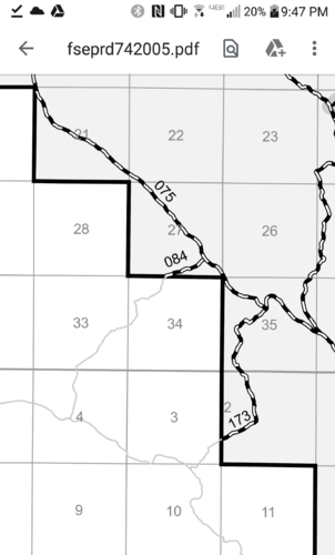
I'm not talking about just access to national forest but actual FS roads. See the attached example here.

Capture+_2020-08-13-21-47-10.png

Both FS 84 and 173 leave the national forest boundary and there is a section of these roads that extend to the county road. The county road map does not include these two FS roads on their map because they aren't maintained by the county. However, if you call the national park office, they will tell you that they maintain these FS roads outside the national forest to the county road and are legal access roads a cross private ground.
 
Yeti GOBOX Collection

Latest posts

Forum statistics

Threads
110,805
Messages
1,935,062
Members
34,883
Latest member
clamwc
Back
Top