Alright everyone, just joined the forum as i am looking for advice on where i should plan my 2020 hunting trip. I'm from Upstate New York(by the border, not the city) and there are somewhat cheap direct flights to Denver. so i am thinking an easy drives worth from Denver (5 hours or less if possible??) i would like to hunt elk and mule deer, i primarily archery hunt whitetail so i would be open to just archery but would do rifle is my chances of getting one would greatly increase. I've never hunting the western rocky terrain but self guided hunts dont scare. any advice??
Navigation
Install the app
How to install the app on iOS
Follow along with the video below to see how to install our site as a web app on your home screen.
Note: This feature may not be available in some browsers.
More options
You are using an out of date browser. It may not display this or other websites correctly.
You should upgrade or use an alternative browser.
You should upgrade or use an alternative browser.
Where should my 2020 hunting trip be?
- Thread starter dwoz1
- Start date
Muley_Stalker
Well-known member

Colorado Parks and Wildlife
Colorado Parks and Wildlife is a nationally recognized leader in conservation, outdoor recreation and wildlife management. The agency manages 42 state parks, all of Colorado's wildlife, more than 300 state wildlife areas and a host of recreational programs. CPW issues hunting and fishing...
cpw.state.co.us
Nick28
Active member
I'd take a look at unit 751 in colorado if I were you. Usually can draw a mule deer tag there with 0 points for the 2nd season and can pick up a OTC elk tag while that season is going on. Can be hunting them both at the same time. Might be crowded near the roads though, just a heads up.
Muley_Stalker
Well-known member
Did you click on my link? You need a lot more info than where to hunt.
Bluffgruff
Well-known member
State land in Colorado is not usually legally accessible for hunting (less than 50% of the total). The current liberal Democrat governor is trying to help hunters gain more access on state lands, but has faced opposition from ranchers on the eastern plains who lease it for cheap grazing and also treat it as private hunting land.
That said, you will be hunting national forest exclusively in unit 751 on your 9 day hike with a rifle alongside your 800 orange clad buddies.
You will love it.
That said, you will be hunting national forest exclusively in unit 751 on your 9 day hike with a rifle alongside your 800 orange clad buddies.
You will love it.
LopeHunter
Well-known member
General WY would be a better experience than CO. No guarantee will draw the WY elk tag. WY mule deer not likely though could apply in WY for elk and deer and draw deer and elk in the random if there is one or more random tags when the dust settles.
Or, MT. Or, ID for elk.
A chance could draw NM but due to timing of when applications are due and when results are released you could draw in two or more states if apply in two or more.
If you are comfortable with a "brown and its down" approach and do not mind having to out-hustle other hunters that also see the same critter you see and may be so clumsy they merely chase it out of the unit then lots of options. Otherwise, may want to set a longer horizon for getting a tag you might find more enjoyable.
Pucky Freak
Well-known member
Welcome to HT! Colorado there are a ton of possibilities for deer and elk. There is a bit of a learning curve to understand the draw data for all the different tag types, seasons, and units, but it is worth figuring it out. The spreadsheets and codes are confusing until you learn how to read them. A ton of people skip all this and just hunt CO OTC because it's simpler, but that also means more crowding during those seasons. @wllm1313 has lots of good info and is worth contacting if you have more specific questions.
Muleyewyo90
Member
- Joined
- Jan 17, 2020
- Messages
- 47
Hop on the WGFD website as well as CPW. Look at odds and areas that may interest you. I agree with others in that you can apply for WY, and if unsuccessful pick up a tag for CO. GoHunt May be a good investment for you as it’s a little easier than navigating the state websites.
kwyeewyk
Well-known member
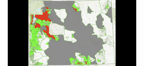
Just curious, is this a custom map or publicly available? GIS software if custom? I'm familiar with ESRI products but have never spent the money for my own.Feel free to PM me about CO.
FWI this is Wy, green is the overlap of public land a NR can hunt in a general unit that is considered “suitable elk habitat”.
Red is the wilderness you can’t hunt.
View attachment 126143
D
Deleted member 28227
Guest
The map was part of a post I made about the WY wilderness guide rule. The data is all created by/pulled from the Wyoming Fish and Game, but yes I used an ESRI product to put it together.Just curious, is this a custom map or publicly available? GIS software if custom? I'm familiar with ESRI products but have never spent the money for my own.
I can try and post a bigger one if your curious I know the thumbnail is somewhat limiting.
kwyeewyk
Well-known member
If you're able to post a larger version I'm sure a lot of people would like to see it. I have most of the data for my current areas of interest, and view it in google earth, but it's cool to see it all in one map for the whole state. Less public than I might have thought. ThanksThe map was part of a post I made about the WY wilderness guide rule. The data is all created by/pulled from the Wyoming Fish and Game, but yes I used an ESRI product to put it together.
I can try and post a bigger one if your curious I know the thumbnail is somewhat limiting.
Similar threads
- Replies
- 16
- Views
- 1K
Latest posts
-
School Me on Hunting In Grizz Country
- Latest: thebestusernamesaretaken
-
-
-


