Will crap. It might be a cold trip this year. That's allot of gas to haul. Buying electric blankets tomorrow!Well we never made it a week. As reference we ran it full out for 8 hours and it probably took care of 2/3 of a 20# tank. Switched to wood after that one.
Navigation
Install the app
How to install the app on iOS
Follow along with the video below to see how to install our site as a web app on your home screen.
Note: This feature may not be available in some browsers.
More options
You are using an out of date browser. It may not display this or other websites correctly.
You should upgrade or use an alternative browser.
You should upgrade or use an alternative browser.
Medicine Bow/Mullen Fire
- Thread starter WyoDoug
- Start date
Carl 9.3x62
Well-known member
A lot of that country needed a good burning.Some pretty dense stands of lodgepole got burned up by the looks of the fire perimeter.
338 win mag
Well-known member
- Joined
- Oct 12, 2009
- Messages
- 505
We're in the same boat. Leaving the woodstove at home. Have a 2 burner Mr. Heater. Should get 2 nights from one 20# bottle. Bringing along 4 - 20# and 1 - 40# cylinder.Will crap. It might be a cold trip this year. That's allot of gas to haul. Buying electric blankets tomorrow!
come2elmo
Well-known member
Yup have at least 4 20# and gonna take our foot off the throttle a bit.We're in the same boat. Leaving the woodstove at home. Have a 2 burner Mr. Heater. Should get 2 nights from one 20# bottle. Bringing along 4 - 20# and 1 - 40# cylinder.
Steve Petersen
Active member
- Joined
- May 21, 2020
- Messages
- 210
dwatling
Well-known member
- Joined
- Mar 18, 2016
- Messages
- 161
No rain in the forecast anytime soon either. I hope the winds die down so they can get infront of this one.
Steve Petersen
Active member
- Joined
- May 21, 2020
- Messages
- 210
This mornings report says it’s now over 117k acres in size making it one of the biggest fires in the country right now.
El Jason
Well-known member
Looking at the 10 day outlook, I'd say it's a pretty good bet it'll burn up a good share of Sheep Mountain as well.
El Jason
Well-known member
It will for about 3-4 years until the dead trees start coming down. Then, you'll be wanting a second fire.On the plus side, maybe Savage Run will be easier to hike through.
We've had a nice NW wind flow lately so maybe Sheep Mt will be spared, at least the part that did not burn a few years ago.Looking at the 10 day outlook, I'd say it's a pretty good bet it'll burn up a good share of Sheep Mountain as well.
dcopas78
Well-known member
It's kinda changing my plans on how to hunt our unit 81 tag since I can't get access to the lower portion of the unit from 230 since it is closed from Riverside to the Colorado border. I think we might just end up trying to camp at the Encampment River campground if we get lucky enough to find a spot. I'm kinda at a loss since I've only been through that area a few times.
Carl 9.3x62
Well-known member
A friend of mine lives just north of Woodslanding and said they were able to return to their house yesterday. The fire activity looks pretty low on that side of the fire, so Sheep mnt may not get burned. South side of the fire is a whole different story.Looking at the 10 day outlook, I'd say it's a pretty good bet it'll burn up a good share of Sheep Mountain as well.
I’m about to say famous last words, and could end up eating crow. “Sheep mtn will be just fine with the squirrel creek and badger Creek burn scars.” They’ve done a good job keeping the fire from getting to structures on fox creek road. It looks like 3-way/state line ranch will be a stopping point for the southeast movement along the Platte River.
ibehuntin
Member
- Joined
- Sep 26, 2020
- Messages
- 40
Let ‘er buck!
BuzzH
Well-known member
Sounding like they may, or have caught it on 230/127 on the south end...the east side just doesn't have the anchor points.
Wind could change everything.
What I'm worried about is new ignitions with people not adhering to the fire restrictions.
Wind could change everything.
What I'm worried about is new ignitions with people not adhering to the fire restrictions.
Carl 9.3x62
Well-known member
You should have waited, it cleared up late morning.We had a very smoky morning in Saratoga Saturday and cut our pronghorn hunt short due to visibility issues. They were back burning near the SE corner of the fire and that smoke settled into the Platte valley.
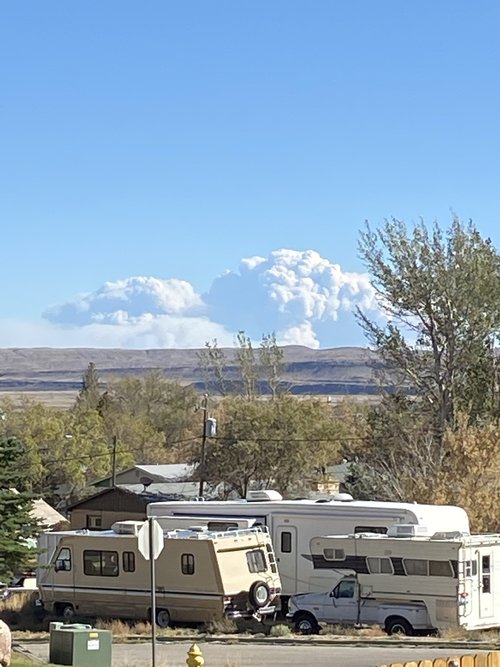
View from east side of blackhall mtn todayView attachment 5949A251-BA1D-4226-9582-E24A1DA592FC.jpeg
Similar threads
- Replies
- 0
- Views
- 409
- Replies
- 45
- Views
- 3K


