Caribou Gear Tarp

OnX is not always correct

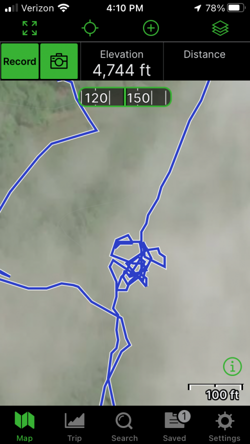
The iPhone GPS can be off too. The loops below are where I stopped to pick some beachnuts along a road. It shows I wandered in an area with 50' diameter, when in reality I never got more than 10' from the east side of the road.

Normally it isn't too bad, but for some reason this place had me bouncing all over even when I was standing still. We were trying to mark the property corners and it was disappointing since you would drop a waypoint and then your position would shift 20' in one direction.

This error is probably the iPhone, not OnX, but it does show the limitations of what you can do.

It is noteworthy that it doesn't bounce around when I was moving. Maybe somebody knows why.
1641573563230.png
 
I hope this thread gets around because you are absolutely right, OnX is not 100% on everything. I have found that their system is fantastic for who the ground is deeded to, but possibly lacking in other areas. In some of the areas I hunt regularly in Colorado I have found that they have several roads marked as BLM roads, but they cross private lands making those sections of the road private. I also found one instance of a county road being mislabeled. When you are on the ground the actual county road is obvious but it could definitely mess up someone's plans when they show up and find that the BLM land this specific spot touches is not actually accessible.

Wonderful tool tool that I will use forever but I doubt they will testify for you in court...
I have the opposite issue. There is a real lag in OnX when ownership changes. They do not real-time access the county databases. When corporate timber goes private and you walk into a fence or orange paint that wasn't there last year, it a pain. There may not be such a convenient clue something has changed to private. Idaho trespass law says the owners do not have to mark their property. It is your responsibility to know.
The other thing that bugs me about all e-mapping tools is that you can hit a historic fence but the blue dot says you are still 100 yards from the line. Who is right?

I definitely agree with the OP. These are handy gadgets, but the they not gospel truth accurate.
 
The BLM route stops at the DNRC land and is not maintained by the BLM unless they have an easement on the road which they sometimes do. In that case you are correct and this would be a federally maintained route across DNRC. I only know of about half dozen or so of these in the MCFO BLM office that I am most familiar with but I’m sure that varies across the state and in some of the gosh forsaken north country BLM lands like where you are probably talking about.
Tangent -

Idaho law says:

Idaho Code 36-1508(a) states: No person shall: Shoot from Public Highway. Discharge any firearm from or across a public highway.

Idaho Code 36-202(x) states: "Public highway" means the traveled portion of, and the shoulders on each side of, any road maintained by any governmental entity for public travel, and includes all bridges, culverts, overpasses, fills, and other structures within the limits of the right-of-way of any such road.
Any governmental agency could mean any federal, state or local governmental agency. Maintained can mean paved, graveled, graded, snow removal or any other maintenance. If the road you are speaking about fits this definition, it would qualify as a public highway.

Even where there is mixed ownership the road commonly has a USFS road number on the map or e-map.

How many of us that bitch about too many ATVs commonly ground sluice grouse walking on these roads?

Here's a situation that's happened to me more than once. You're not road hunting, just driving to the trailhead. You come around a corner and there is the bull or buck of a lifetime standing dumb as rock in the road. I confess I have been one jammed seatbelt buckle away from breaking this law.
 
The iPhone GPS can be off too. The loops below are where I stopped to pick some beachnuts along a road. It shows I wandered in an area with 50' diameter, when in reality I never got more than 10' from the east side of the road.

Normally it isn't too bad, but for some reason this place had me bouncing all over even when I was standing still. We were trying to mark the property corners and it was disappointing since you would drop a waypoint and then your position would shift 20' in one direction.

This error is probably the iPhone, not OnX, but it does show the limitations of what you can do.

It is noteworthy that it doesn't bounce around when I was moving. Maybe somebody knows why.

View attachment 208145
I noticed this too last year in South Texas on a Nilgai hunt. My hunting buddy shot a cow a bit far back and we were following the blood trail, I was marking spots along the way and had the tracker on too. If the app would close, when I re-opened it I noticed the GPS had a hard time getting back to the spot I was on even if I hadn't moved. There was a bit of cell service and I tried using cell service too and it was about the same. Even with the app open while we were walking there were times the dot was moving back and forth up to I'd say 50' at times. I'd say it's likely an iPhone GPS chip issue. I'd assume the accuracy is not equal to a hand held GPS. Regardless I mainly use mine to make sure I'm at least heading the right direction and mark waypoints that I can at least get back to the vicinity of. Also regarding property boundaries, I try not to hunt close enough to a property line where if I don't make a great shot I have to worry about the animal going onto private. I don't really have higher expectations that that. It's a convenience tool for me more than anything.
 
Does anyone use Huntstand in the western states? I was using OnX in Illinois for a while but started noticing property line discrepancies and land ownership incorrect several times. I've had a lot better luck with huntstand. Never used it outside of Illinois though.
 
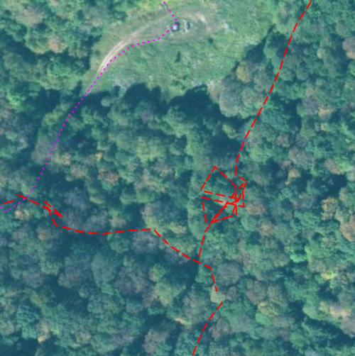
FWIW, I used Gaia GPS on the same walk and it jumped around just as much. It isn’t normally this bad, but you have to keep it in mind. 96693BE4-E1E6-4E00-B1B4-AE5BBFA26F54.png
 
This might be a more reasonable example but in one county in WA in particular the land ownership data isn’t digitized, which means that OnX is working with interpretation of lot descriptions which netted me a visit from the local Sheriff and a handful of local folks while bird hunting a couple years ago. I assume this is true for many other jurisdictions across the country.

Keep a cool head out there,

Al
 
I was shocked to see it show a bunch of trails across our family’s property. Made it look very inviting. The main trail it showed was a single track path that trespassing mountain bikers have made. We have blocked it off many times but they continue to go through. Somehow in heavy timber OnX shows it as a trail or road. There are also others that show up on there that were logging trails made from skidders when we logged it. I figure it must use something that picks up stuff from aerial imagery.
 
I was shocked to see it show a bunch of trails across our family’s property. Made it look very inviting. The main trail it showed was a single track path that trespassing mountain bikers have made. We have blocked it off many times but they continue to go through. Somehow in heavy timber OnX shows it as a trail or road. There are also others that show up on there that were logging trails made from skidders when we logged it. I figure it must use something that picks up stuff from aerial imagery.
Could it be from an old map that was digitized?
 
All the issues are because they pull the data from agencies and governments not create it
Exactly, all these companies are data aggregators not creators. Your county assessor/clerk/gis group manage parcel data it's accuracy is on them. Some counties outsource this work and every county has it's own data licensing agreements. Some counties data is open source with an API that you can use to directly pull into your database, other counties you have to purchase data, some you can do that digitally, I know of a number that only provide a CD or thumb drive. I've also encountered a number of counties that still rely entirely on plat books. Those are the "holes" in OnX data typically.
 
The other thing that bugs me about all e-mapping tools is that you can hit a historic fence but the blue dot says you are still 100 yards from the line. Who is right?

I definitely agree with the OP. These are handy gadgets, but the they not gospel truth accurate.
I've worked as a GIS professional in the OG industry for over a decade now, before that worked for a county GIS department.

Data especially in rural areas is so much more f-ed up then you think. Putting pooling units together, for horizontal drilling in areas like PA, WV, parts of Texas etc. is a dumpster fire. I'll have a survey team shoot a property and there will be a 20% discrepancy in acreage from what the owners deed says. Old fences are meaning less, pins are all jacked up, most and I mean a startlingly high percentage of metes and bounds descriptions don't "close".

This is what 90% of the leases I mapped in PA/WV ended up looking like... and I mapped hundreds and hundreds of leases.
1641823431208.png
This is probably getting too much into the weeds, and I would love to find a 19th century historian or someone that knows about old survey techniques that can tell me if I'm correct, but I think the issue is that old school techniques for measuring angles distance etc are great for flat areas but don't really work for mountainous terrain, especially where it's really thick and you can't see more than 40-50 yards. Basically if you think about how a range finder works and or shooting down or uphill. People were using the line of sight distance not the angle compensated distance. Therefore there math was way off.

A 1mile by 1mile "section" in Iowa might have 30% less surface area than a super steep 1 mile by 1 mile section in west Virginia.

That's just speculation, but point being I've argued with dozen of land owners, lawyers, etc about boundary lines... to the point we put "lease acres being screwed up" language into our leases.

So many examples out there of properties being X acres and being passed through the generations, then sold. The new buyer has the property surveyed, realizes it's 30acres smaller and doesn't want to pay taxes on acreage they don't own.
 
I've worked as a GIS professional in the OG industry for over a decade now, before that worked for a county GIS department.

Data especially in rural areas is so much more f-ed up then you think. Putting pooling units together, for horizontal drilling in areas like PA, WV, parts of Texas etc. is a dumpster fire. I'll have a survey team shoot a property and there will be a 20% discrepancy in acreage from what the owners deed says. Old fences are meaning less, pins are all jacked up, most and I mean a startlingly high percentage of metes and bounds descriptions don't "close".

This is what 90% of the leases I mapped in PA/WV ended up looking like... and I mapped hundreds and hundreds of leases.
View attachment 208503
This is probably getting too much into the weeds, and I would love to find a 19th century historian or someone that knows about old survey techniques that can tell me if I'm correct, but I think the issue is that old school techniques for measuring angles distance etc are great for flat areas but don't really work for mountainous terrain, especially where it's really thick and you can't see more than 40-50 yards. Basically if you think about how a range finder works and or shooting down or uphill. People were using the line of sight distance not the angle compensated distance. Therefore there math was way off.

A 1mile by 1mile "section" in Iowa might have 30% less surface area than a super steep 1 mile by 1 mile section in west Virginia.

That's just speculation, but point being I've argued with dozen of land owners, lawyers, etc about boundary lines... to the point we put "lease acres being screwed up" language into our leases.

So many examples out there of properties being X acres and being passed through the generations, then sold. The new buyer has the property surveyed, realizes it's 30acres smaller and doesn't want to pay taxes on acreage they don't own.
This^! I think today with the advent of geospatial drone data merged with historical and current surveyor’s benchmarks COULD make for the most accurate lay of the land ever. Yet we’ve strayed far off the OP now. I agree with other commentators and do use Gaia, Onx and current paper maps if available. Yeah, might still run into a jam, but not for lack of trying.
 
I've worked as a GIS professional in the OG industry for over a decade now, before that worked for a county GIS department.

Data especially in rural areas is so much more f-ed up then you think. Putting pooling units together, for horizontal drilling in areas like PA, WV, parts of Texas etc. is a dumpster fire. I'll have a survey team shoot a property and there will be a 20% discrepancy in acreage from what the owners deed says. Old fences are meaning less, pins are all jacked up, most and I mean a startlingly high percentage of metes and bounds descriptions don't "close".

This is what 90% of the leases I mapped in PA/WV ended up looking like... and I mapped hundreds and hundreds of leases.
View attachment 208503
This is probably getting too much into the weeds, and I would love to find a 19th century historian or someone that knows about old survey techniques that can tell me if I'm correct, but I think the issue is that old school techniques for measuring angles distance etc are great for flat areas but don't really work for mountainous terrain, especially where it's really thick and you can't see more than 40-50 yards. Basically if you think about how a range finder works and or shooting down or uphill. People were using the line of sight distance not the angle compensated distance. Therefore there math was way off.

A 1mile by 1mile "section" in Iowa might have 30% less surface area than a super steep 1 mile by 1 mile section in west Virginia.

That's just speculation, but point being I've argued with dozen of land owners, lawyers, etc about boundary lines... to the point we put "lease acres being screwed up" language into our leases.

So many examples out there of properties being X acres and being passed through the generations, then sold. The new buyer has the property surveyed, realizes it's 30acres smaller and doesn't want to pay taxes on acreage they don't own.
I'm old enough to remember dragging chains and transit through the woods.
 
Could it be from an old map that was digitized?
Not sure but it was never a road until it was logged. We’ve had the property for over 50 years so perhaps it was something waaaaay back. We blocked off the logging road and someone came in with a small tractor and moved all the dirt! So they really think its a road I guess.
 
This is probably getting too much into the weeds, and I would love to find a 19th century historian or someone that knows about old survey techniques that can tell me if I'm correct, but I think the issue is that old school techniques for measuring angles distance etc are great for flat areas but don't really work for mountainous terrain, especially where it's really thick and you can't see more than 40-50 yards. Basically if you think about how a range finder works and or shooting down or uphill. People were using the line of sight distance not the angle compensated distance. Therefore there math was way off.
The main problem with old deed descriptions that do not "close" like you mention typically is because the parcel was never actually surveyed, or if it was surveyed it was done very poorly. Most poor legal descriptions that are on a deed were more than likely done without any survey at all and were developed by a lawyer.

Surveying measurements back in the day of Chains and links, as well as steel tapes took into account elevation or at least were supposed to. Distances could be recorded very accurately as long as the surveyors were not inebriated which most were well known for being unfortunately. They would only be able to go far per measurement as long as they could keep the tape or chain perfectly flat or level. In hilly terrains this would make the horizontal measuring very difficult and this practice was termed "breaking tape".

Interior angles or bearings were recorded using large compass's affixed to a tripod and could be done very accurately as well, but seldom were.

Being a Professional Land Surveyor myself for going on 20 years now I have seen just what you mention even on some more recent deeds. I typically know that a deed won't close if the bearings are labeled only to the nearest minute of degree, or N 75°40' W for example. In this day and age a parcel of property should not be conveyed or transferred without an up to date boundary survey but most do not want to pay for what a decent boundary survey costs and the previous legal description gets carried over.
 
as long as the surveyors were not inebriated which most were well known for being unfortunately.
1641842539728.png

... land work in West Virginia, always interesting.


In this day and age a parcel of property should not be conveyed or transferred without an up to date boundary survey but most do not want to pay for what a decent boundary survey costs and the previous legal description gets carried over.
100% agree, although a boundary survey can also led to major title issues so is one reason why it's often not done. I've been a part of a couple transactions where a re-survey would have lead to a title company not insuring title, essentially the resurvey would cloud title.

What's kinda interesting in O/G is you have to pay apportiontly based on acreage in a drilling unit. Meaning exact acreage is important, and often your in communities where farms have been owned by the same families for generations, and those families have 0 intention of ever selling. So it's kinda unlike normal real estate work where a developer is buying a property to subdivide or someone is trying to sell their property and "clean it up"... and it's not one property. You are trying to get 500 hundred small farms to all have perfect boundary lines with no vertices overlap so you can say:

In this 2000 acre unit:

Jim Owens = 22.3 acres
Brad Jones = 25.3 acres
Jill Bradford= 29.0 acres

and the sum of all the acreage needs to add up to exactly 2000 acres.

I think most surveyors do a really good job, but rarely does a surveyor company get tasked with cutting up 30,000 acres of 25 acre-ish tracts in order to pay out 100MM, and you aren't creating a new subdivisions where it starts out perfect, you are reconciling deeds that are all over 100+ years old, so if you make any change someone is getting hosed.

And as you might imagine no one is ever upset that the family "100 acre farm that has been in my family for 5 generations" is now 84.7 acres.
 
Back
Top