Dougfirtree
Well-known member
The writing is on the wall (maybe the wall of the canyon). Unless something changes in a big way, a whole lot of people in the southwest are going to become my neighbors before too long.


Follow along with the video below to see how to install our site as a web app on your home screen.
Note: This feature may not be available in some browsers.

Promise!The writing is on the wall (maybe the wall of the canyon). Unless something changes in a big way, a whole lot of people in the southwest are going to become my neighbors before too long.
")
 www.kunc.org
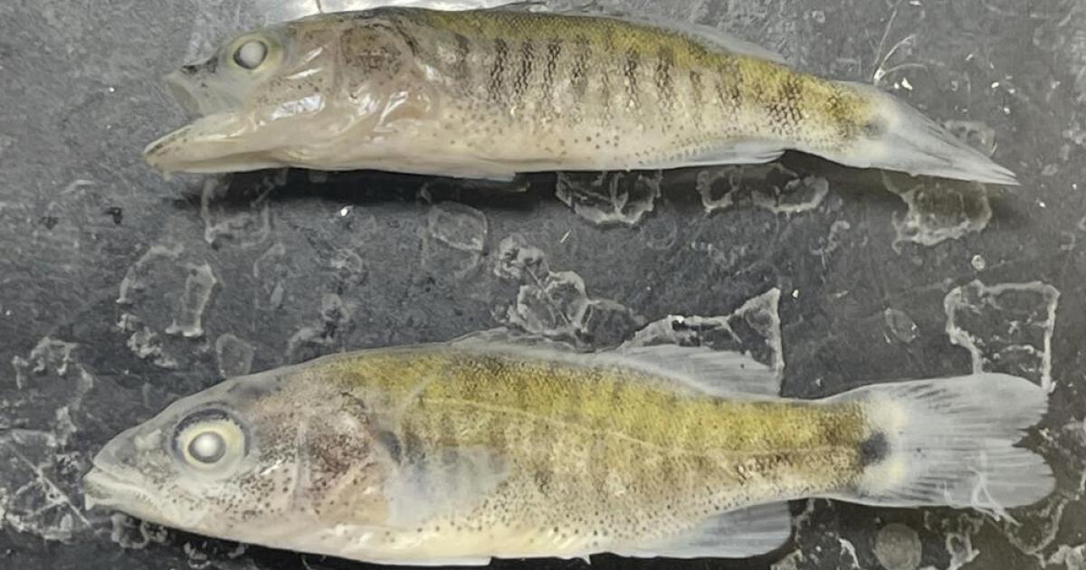
Biologists’ fears confirmed on the lower Colorado River
Smallmouth bass feast on humpback chub, an ancient, threatened fish that’s native to the river, and biologists have been working hard to recover the chub. The predators wreaked havoc in the upper river, but were held at bay in Lake Powell where Glen Canyon Dam has served as a barrier for years —...

While many, if not all, would question that use, water rights are a form of property right. You simply can't "take" that right away, either through outright takings or changing the definition of a beneficial use (some ability exists here). The answer is that governments simply need to buy out other users, not to scrape the entire western law framework. Every municipality tapping the Colorado should have an annual budget to buy ag water rights.It seems like there will be a reckoning at some point about how water is used in the increasingly parched lower Colorado River Basin. For example, is growing alfalfa on State Trust Land for Saudi Arabian livestock the best use of our water?
Who has the water rights in that story? And I didn't say anything about taking water rights. You're suggesting the stick approach. Perhaps there's a carrot approach for those with water rights.While many, if not all, would question that use, water rights are a form of property right. You simply can't "take" that right away, either through outright takings or changing the definition of a beneficial use (some ability exists here). The answer is that governments simply need to buy out other users, not to scrape the entire western law framework. Every municipality tapping the Colorado should have an annual budget to buy ag water rights.
")
Bad data, both in terms lack of sufficient data, and just that the data that was used was viewed as representing the wrong portion of the bell curve than it actually did. Meaning they used X number of years made assumptions that was an average (or not even that, but assumed they knew where those years plotted on the curve of possibility), modeled out all the potential precipitation scenarios and designed the dam. Turns out, drought is way more prevalent in that basin, flows are more variable than they thought. But @TOGIE would know WAY more than me.Bruh idk much about this kinda stuff but that’s so insane that they built that big massive sob and it’s shitting out after like 60 years.
How tf did that happen?
OK, fair enough, if that reporting is accurate, step one is AZ drafting GW regs so that they align with western water law. I thought that was pretty common and that CA was the last to hop on the bandwagon.Who has the water rights in that story? And I didn't say anything about taking water rights. You're suggesting the stick approach. Perhaps there's a carrot approach for those with water rights.
Yep, we said the same thing in different ways.Bad data, both in terms lack of sufficient data, and just that the data that was used was viewed as representing the wrong portion of the bell curve than it actually did. Meaning they used X number of years made assumptions that was an average (or not even that, but assumed they knew where those years plotted on the curve of possibility), modeled out all the potential precipitation scenarios and designed the dam. Turns out, drought is way more prevalent in that basin, flows are more variable than they thought. But @TOGIE would know WAY more than me.
OK, fair enough, if that reporting is accurate, step one is AZ drafting GW regs so that they align with western water law. I thought that was pretty common and that CA was the last to hop on the bandwagon.
I would say I'm not advocating for a stick. In my mind a stick would be to pass a law saying irrigation isn't an authorized beneficial use. I'm advocating for a market approach. It's successfully used all over the west, though I'm most familiar was WA. Muni's just need to purchase more existing water rights from existing irrigators. We have all kinds of approaches, from outright buying farms, to buying the water right off of a farm but allowing them to keep grazing or growing dry land crops, paying for irrigation improvements to reduce wastage (evap), then getting a portion of that "savings", etc.
Bad data, both in terms lack of sufficient data, and just that the data that was used was viewed as representing the wrong portion of the bell curve than it actually did. Meaning they used X number of years made assumptions that was an average (or not even that, but assumed they knew where those years plotted on the curve of possibility), modeled out all the potential precipitation scenarios and designed the dam. Turns out, drought is way more prevalent in that basin, flows are more variable than they thought. But @TOGIE would know WAY more than me.

The progression in my mind isYep, we said the same thing in different ways.