Current MT Weather map

Winter stuff keeps happening around here (SW MT)......10-15" of snow possible above 5500' during the current winter storm warning. A rock slide has closed the road between Gardiner and Cooke City eight miles from Mammoth. The fun continues.......
 
Beginning to rain again in Billings.......this end of the state does not need more rain. it is supposed to rain off & on (mostly on) for the next two days. calling for up to another 3 inches possible by tomorrow. Our thoughts & prayers go out to those under water.
 
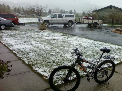
What a treat this year has been. I woke up to this crap yesterday morning:mad: I went for a horse ride up Hyalite yesterday and the amount of snow still on the logging roads just halfway up the canyon is staggering. Most roads still have a mound of snow 1- 2 feet deep in the center.

maysnowstorm.jpg
 
Mrs. Fin says we are going walleye fishing this week, even if we have to drive the boat to the reservoir. Woman is getting kind of edgy with this delay in her fishing fix. Thinking of taking her down to the USFWS hatchery and let her catch some spotted carp with a Snoopy pole, if it gets much worse.

Headed out tomorrow morning. I showed her this flood watch warning, but she said, "Guess you better figure out how to deal with that. We're going fishing."

Hmmmm. Fortunately, the weather is supposed to, I say supposed to, clear by Tuesday morning. I sure hope so.

Miller, Nemont, BreaksRunner, you guys still afloat up there? Need me to bring any extra provisions for you?

Areal Flood Watch Statement as of 11:05 AM MDT on May 29, 2011

... Flood Watch remains in effect from 6 PM MDT this evening through late Tuesday night...

The Flood Watch continues for

* a portion of northeast Montana... including the following
areas... central and southeast Phillips... central and southern
valley... Daniels... Dawson... eastern Roosevelt... Garfield...
McCone... northern Phillips... northern valley... Petroleum...
prairie... Richland... Sheridan... southwest Phillips... western
Roosevelt and Wibaux.

* From 6 PM MDT this evening through late Tuesday night

* a potentially significant flood event is expected across
northeast Montana starting late Sunday evening due to another
round of moderate to heavy rain. The rainfall is expected to
taper off Tuesday but it will take some time for all the water
to drain out into the creeks and then into area rivers. This
will lead to higher water next week again on the milk and
Yellowstone rivers in northeast Montana.

* With soils already saturated across the region... additional
expected rainfall of 1 to 3 inches with locally higher amounts
will likely further aggravate flooding concerns and make
numerous area roadways... especially gravel and dirt roads
impassable. Anyone traveling during this Holiday weekend will
likely need to consider alternate routes by Monday and
Tuesday.

Precautionary/preparedness actions...

A Flood Watch means there is a potential for flooding based on
current forecasts.

Those living in areas prone to flooding should be prepared to
take action should flooding develop... especially if you have
already experienced flooding this year.

I hesitate to even discuss the idea of a fishing trip to these areas, given how much damage the flooding is wreaking on eastern Montana and western North Dakota. Enough already. We need this to stop and we need it to stay cool through the month of June.

Given our snowpack levels and the fact they have not even started to melt, a warm rain, or a heat wave would be disastrous for the already flooded communities. The rivers will be full all summer. Hopefully the weather will provide for a slow release of the snowpack. If not, we are screwed.
 
Mrs. Fin says we are going walleye fishing this week,

Headed out tomorrow morning. I showed her this flood watch warning, but she said, "Guess you better figure out how to deal with that. We're going fishing."


One thing about it. If it's a bust you can say. Told ya so. Or you may just be the Hero. Let's hope the later. :D
 
It's still piling up in the high country. The little belts and the front keep getting hammered. I took the horse up in the big belts yesturday, nice as heck out. There is still tons of snow on the north slopes. If this keeps up looks like we will be elk hunting in boats this year.

Winter Storm Warning

URGENT - WINTER WEATHER MESSAGE
NATIONAL WEATHER SERVICE GREAT FALLS MT
247 PM MDT SUN MAY 29 2011

MTZ012-050-051-054-300500-
/O.CON.KTFX.WS.W.0024.110530T0000Z-110531T0600Z/
CASCADE-JUDITH BASIN-FERGUS-MEAGHER-
INCLUDING THE FOLLOWING LOCATIONS...KINGS HILL PASS
247 PM MDT SUN MAY 29 2011

...WINTER STORM WARNING REMAINS IN EFFECT FROM 6 PM THIS EVENING
TO MIDNIGHT MDT MONDAY NIGHT FOR ELEVATIONS ABOVE 5500 FEET...

A WINTER STORM WARNING FOR ELEVATIONS ABOVE 5500 FEET REMAINS IN
EFFECT FROM 6 PM THIS EVENING TO MIDNIGHT MDT MONDAY NIGHT.

* TIMING AND MAIN IMPACT: SNOW...HEAVY AT TIMES...WILL DEVELOP IN
THE MOUNTAINS TONIGHT AND CONTINUE TO FALL THROUGH MONDAY EVENING.
SNOWFALL RATES OF 1 TO 2 INCHES PER HOUR WILL BE POSSIBLE AT
TIMES LATER TONIGHT AND ON MONDAY MORNING.

* SNOW ACCUMULATIONS: TIME OF DAY AND SNOWFALL RATE WILL PLAY A
LARGE ROLE IN SNOWFALL ACCUMULATIONS IN THIS LATE SEASON
STORM. HOWEVER THE POTENTIAL EXISTS FOR 10 TO 15 INCHES OF
NEW SNOW BY MONDAY EVENING FOR ELEVATIONS ABOVE 5500 FEET.

* ELEVATIONS: FOR ELEVATIONS ABOVE 5500 FEET.

* VISIBILITIES: EXPECT VISIBILITIES TO BE REDUCED TO LESS THAN
ONE HALF MILE AT TIMES ACROSS MOUNTAIN PASSES.

PRECAUTIONARY/PREPAREDNESS ACTIONS...

A WINTER STORM WARNING FOR HEAVY SNOW MEANS SEVERE WINTER WEATHER
CONDITIONS ARE EXPECTED OR OCCURRING. SIGNIFICANT AMOUNTS OF
SNOW ARE FORECAST THAT WILL MAKE TRAVEL DANGEROUS. ONLY TRAVEL IN
AN EMERGENCY. IF YOU MUST...KEEP AN EXTRA FLASHLIGHT...FOOD...AND
WATER IN YOUR VEHICLE IN CASE OF AN EMERGENCY.
 
Fin,

My kid and I went fishing at Fort Peck on Sunday morning. The lake has completely changed with the rise this spring. Have to be careful with all the flooded trees that grew up during the dry years since 1997. Tough fishing with all the snags and dragging bottom bouncers is out of the question. Finally anchored the boat over some structure and marking fish on the fish finder. Jigged with a yellow jig and a leech. Caught three 8 to 10 lb northerns and 4 2-4 lb walleyes. Was off the water by noon due to the forecast for high winds.

The sight of them opening all the gates on the spillway to dump 50,000 cfs will be something to see. My kids has been practicing for baseball for over a month and has been able to play on double header. Our fields are flooded again so we have to go to Wolf Point to practice and play.

On the plus side I have never seen it as green around this country as it is right now. I thought last years wet summer would never be beat for greenery in NE Montana but this spring has it beat. Could use some drying out for a day or two though. At least so the farmers can finish their seeding.

80 degrees by Thursday. Hope that doesn't mean a rapid melting of the snowpack.

Nemont
 

Latest posts

Forum statistics

Threads
118,079
Messages
2,178,929
Members
38,436
Latest member
carlsonmatthew6
Back
Top