Whitetail Help

jmslowik

New member
Joined
Jul 4, 2009
Messages
3
Location
Omaha, Nebraska
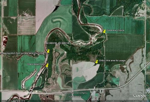
Im looking at a wildlife management spot that I want to hunt. I have only been hunting three years and to me this looks like a prime spot although it is small im thinking major potential. Any ideas on how to hunt this spot? I am putting the gps cordiantes on here from google maps. Just place them in the google search bar and youll be there. Its the area from the highway to the river.

GPS 40.060238,-95.996218
 
won't zoom enough to tell much, but from what I see, you want to see where the deer are crossing that river. if they are at all. the inside bend where the river falls back south after the north run would be a starting point for me. also, if its on the land you can hunt, the places where the river branches off(2 spots) should be looked at. what kind of land is this? ag? forest? flatland? is there are any spots where trees run into ag land, walk the perimeter. there should be trails leading to and from the fields. if there is no ag land nearby, walk and see what they are eating in the area. acorns? persimmons? if its heavily wooded, might be a bedding spot? look for the thickest, nastiest stuff you can find. thats where the deer will go when pressured. especially if you have acorns nearby.
 
here is the area from google maps

jmshowik-
welcome to the site...and good to see a fellow nebraskian.
I hope this all worked out...I loaded an attachment of the area coordinates from google maps and tagged a couple of areas that I'd suggest you take a look at.
I agree with you it looks like a good area. Overall I'd walk the place, find major trails, see where entering/exiting the property and look for bedding areas. For rifle I also like to get where I can see a ways and cover an area...like up high on creek banks or edge of timber /grain field...or edge of timber/clearing as I notice there are a couple of those on the northern side between timber and creek.
I put 4 pins to mark areas of interest, didn't know if the verbage would open so included it as follows:
Where crossing ditch from private land into timber?
I'd look around in this area to see where the deer are crossing to use this ditch going west onto the private land/fields. The deer will follow this in to/out of the timber.
Check down here
This looks like a good area with breaks between timber into possible grass area/ag field for food or maybe even a game and parks game plot?
I'd look around down here really good as it's a natural corridor that follows the creek , has food bedding possibilities and also is fairly buffered from human traffic by the timber on the east there.
Check this area for usage
A finger coming out into what will probably be a grain field. Check around this area...see where the deer are coming in and out...may be feeding in that pocket to the east or west.
Good eve choiceGood funnel from timber/creek into crops for food:
Check around in here for sign and usage...on the banks coming outa the creek or thru the timber into the fields.
Would think with prevailing westerly..sw or nw winds this would be a great eve stand and you could access from downwind side.
hope this helps and good luck hunting!
 

Attachments

  • jmslowik.jpg
    jmslowik.jpg
    70.5 KB · Views: 128
The land type is on a slight hill if you follow the road into the small white area which is parking. It goes down a dirt road to the small opening in the middle of all the trees. i havent had to much time to walk the whole area but will be doing so hopefully this week. i appreciate all the info and well hope to show some good pics come deer season.
 
Pull up Google Earth, if you have it. I would 1st glass the area from the tear drop shape to see where the deer are coming out from the wood line. Then you'll get a good idea of where you want to start scouting. Unless you can read deer sign that is the best way to start.


<coordinates>-95.996218,40.060238,0</coordinates>
 
Overall it is a nice looking area for WT. I'm not sure if you have hunted much public land in Nebraska, but an access trail up the middle generally is not an asset. So with that being said, you probably won't find the big one within eyesight of that trail during legal shooting hours, unless he's absolutely "lovestruck".

Keeping the access trail in mind, I would give strong consideration to four foodplots in particular. First, the plot northwest of the parking lot would be a logical place to start scouting (assuming that trees block it's view from the parking lot. Second and third would be the plots on the southwest corner of the property. I like how these are surrounded by timber and I would be sure to scout the thin strip of trees between the river and foodplots 2 & 3 (it looks like a nice travel corridor). The fourth consideration would be the narrow foodplot that runs north & south and sits to the southeast of the parking lot...it appears to be relatively secluded from disturbance. Also check out the opening north of the parking lot in the middle of the trees....it's possible that it could have been an old alfalfa field. Deer usage of foodplots is obviously contingent upon what crop is planted and the time of season that you are hunting. Hunting near alfalfa is often productive to just after the first hard frost. Alot of times WMA managers plant cane or milo in the foodplots with pheasants in mind. Those two crops are not the preferred choice for WT especially when corn and soybeans are available on the other side of the fence. Don't become disappointed if you do not see heavily used trails during your early season scouting. It has been my experience that deer will have many entry/exit points to a standing cornfield when it's adjacent to good cover. Once the corn has been harvested, then the deer really begin to take advantage of funnels. Winter wheat provides an excellent late-season food source for deer and should be a strong consideration for December hunting (probably not much wheat that far east).

It's very possible that deer are utilizing the timber and warm-season grasses on the WMA as a bedroom and the large privately owned ag fields as the kitchen. I would contact the adjacent landowners for permission to hunt as well. This would give you many more options to hunt with different winds.

I also like Duckheads suggestions, although I think his two eastern points on the map may fall on private land. Again contact the adjacent landowners.

Good luck and hope to see some photos this fall.
 

Latest posts

Forum statistics

Threads
111,156
Messages
1,949,205
Members
35,058
Latest member
idelkhntr13
Back
Top