Navigation
Install the app
How to install the app on iOS
Follow along with the video below to see how to install our site as a web app on your home screen.
Note: This feature may not be available in some browsers.
More options

You are using an out of date browser. It may not display this or other websites correctly.
You should upgrade or use an alternative browser.
You should upgrade or use an alternative browser.
Map apps, help!
- Thread starter Wyohunt
- Start date
JungleShooter
New member
World Topo Map (Android, probably on iPhone as well) — it gives you the elevation lines, and allows you to switch between
▪map view, with an overlay of the street map of GoogleMaps, and
▪satellite view.
The free version has ads.
Matthias
▪map view, with an overlay of the street map of GoogleMaps, and
▪satellite view.
The free version has ads.
Matthias
kwyeewyk
Well-known member
Most of my maps are old and probably not very accurate. Satellite images would be cool.
I've had access to high end GIS/GPS products most of my adult life, and I'd recommend OnX Hunt and Google Earth. Designed for hunting, simple to learn and use (lots of info on this site and BigFin's video's, fairly cheap, and you can use an existing smart phone (if you have one) as your GPS. GoHunt has similar options but a little more expensive, haven't used it so can't say what it's like but seems slightly more complicated than OnX from general impression.
JungleShooter
New member
So, do I understand this correctly?
OnX Hunt costs $30 per year, and the Elite membership $100/y?
Is there a free version, or not?
Thanks for those links, those are some very powerful map options!
Matthias
OnX Hunt costs $30 per year, and the Elite membership $100/y?
Is there a free version, or not?
Thanks for those links, those are some very powerful map options!
Matthias
Nameless Range
Well-known member
In the world of mobile mapping software, I view OnX much like factory ammunition. You get what you get. It works, and requires little intellectual investment.
Avenza is my version of something like hand loading. Refining a product, making it exactly what I want. Better than off the shelf.
Being new I would recommend OnX with your smartphone and see how ya like it.
Avenza is my version of something like hand loading. Refining a product, making it exactly what I want. Better than off the shelf.
Being new I would recommend OnX with your smartphone and see how ya like it.
kwyeewyk
Well-known member
I found OnX elite on Camofire for $60.So, do I understand this correctly?
OnX Hunt costs $30 per year, and the Elite membership $100/y?
Is there a free version, or not?
Thanks for those links, those are some very powerful map options!
Matthias
Avenza is free, as Nameless Range said a lot of customization is possible, but a lot more of a commitment on your part to make/get what you need, so not the best for beginners. If you have some experience though Avenza is probably one of the best free options.
In the world of mobile mapping software, I view OnX much like factory ammunition. You get what you get. It works, and requires little intellectual investment.
Avenza is my version of something like hand loading. Refining a product, making it exactly what I want. Better than off the shelf.
Being new I would recommend OnX with your smartphone and see how ya like it.
I use Avenza a lot as a firefighter while fighting brush fires. Most incidents use it for mapping and intel gathering. I really enjoy it and feel that it is fairly user friendly. Are you able to get the same private land information on avenza as you would OnX??
Nameless Range
Well-known member
Yes.I use Avenza a lot as a firefighter while fighting brush fires. Most incidents use it for mapping and intel gathering. I really enjoy it and feel that it is fairly user friendly. Are you able to get the same private land information on avenza as you would OnX??
There really isn’t anything meaningful in OnX that isn’t publicly available.
Yes.
There really isn’t anything meaningful in OnX that isn’t publicly available.
Nice!
I guess the main thing you would be losing then is that OnX has a desktop version and Avenza does not... as far as I know
Nameless Range
Well-known member
Nice!
I guess the main thing you would be losing then is that OnX has a desktop version and Avenza does not... as far as I know
I suppose so. Though I make maps for Avenza using GIS software on the desktop. Im aware most folks don’t know how or even if they did wouldn’t want to do that.
I guess I just always bring up
Avenza because it has been such a solid product for me and sometimes seems forgotten.
D
Deleted member 28227
Guest
Property boundaries?Yes.
There really isn’t anything meaningful in OnX that isn’t publicly available.
Sure you can get Fed and some state public land boundaries, but private land boundaries definitely not.
Nameless Range
Well-known member
I only hunt in Montana where private property boundaries are publicly available, so I do not know about other states.Property boundaries?
Sure you can get Fed and some state public land boundaries, but private land boundaries definitely not.
That said, if private property boundaries are in OnX for other states, I would think that they have gone through the trouble of consolidating county data that is publicly available. Maybe they pulled 10s of thousands of COS’s and digitized em, but that would be impressive. I’m not too familiar with what’s available in other states.
D
Deleted member 28227
Guest
Let’s put it this way, it’s such a mess in some states that there are third party vendors that charge $5000 per county, for a shapefile, counties that don’t have any mapping systems of their own or any state system.I only hunt in Montana where private property boundaries are publicly available, so I do not know about other states.
That said, if private property boundaries are in OnX for other states, I would think that they have gone through the trouble of consolidating county data that is publicly available. Maybe they pulled 10s of thousands of COS’s and digitized em, but that would be impressive. I’m not too familiar with what’s available in other states.
At this point I haven’t found a better app for the traveling hunter, but some state specific platforms are way better.
Khunter
Well-known member
camofire.com sells Onx elite memebership every spring for 40% off. great deal for $59.99.So, do I understand this correctly?
OnX Hunt costs $30 per year, and the Elite membership $100/y?
Is there a free version, or not?
Thanks for those links, those are some very powerful map options!
Matthias
Actually they have it available well after the sle sometimes, just call and ask.
kwyeewyk
Well-known member
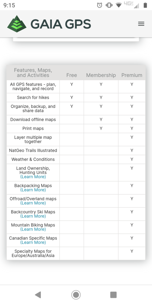
Hadn't heard of this one, will have to check it out, I like OnX but have had some glitches and problems with it every once in a while.Or $36 for Gaia premium with a lot more features
Similar threads
- Replies
- 40
- Views
- 2K
- Replies
- 0
- Views
- 463