Caribou Gear Tarp

Bureau of Land Management Seeks Help Increasing Access to Public Lands

It works now. I can't get the BLM land to fade out enough to see really well the land/drainages I commented on. Hopefully it was close. I plan on passing this info along to friends who I know would comment. I highly recommend spreading the word as far as possible. It doesn't seem like it, but BLM does actually take and read the comments. And the squeaky wheel gets the grease, the more comments on a particular area tend to elevate the issue. CO has much landlocked public BLM country bound up by a small private parcel at the bottom of a drainage preventing access. IMHO the main problem with BLM travel management plans is they seem to only look in 2D without factoring in ridges, elevation, water, and realistic access, even unmotorized access.
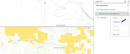
Under "layer list".
Capture.JPG
 
Is there a publicly available map of the legally inaccessible lands that OnX created (without needing a subscription)? The comment map only shows BLM, so it's hard to tell if there are other agency's lands that make it publicly accessible.
 
Is there a publicly available map of the legally inaccessible lands that OnX created (without needing a subscription)? The comment map only shows BLM, so it's hard to tell if there are other agency's lands that make it publicly accessible.

In a word No, the report they did was more education and talked about GIS methodology to identifying possible land locked parcels and the various state specific issues.

 
Could anyone else see other people submissions? It was a blank map for me. I ended up highlighting several large areas and just saying we need access and consolidation.
 
Back
Top